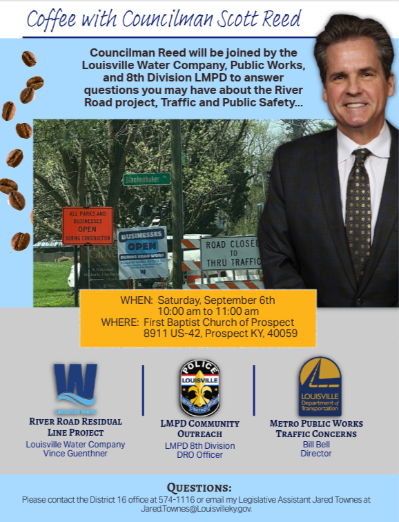
 Please be advised of a Coffee with Your Councilman event Saturday, September 6th from 10:00 am to 11:00 am at First Baptist Church of Prospect, 8911 US-42, Prospect KY, 40059.
Join Councilman Reed in a relaxed setting, alongside representatives from the Louisville Water Company, Public Works, and the 8th Division LMPD, to ask questions, share suggestions, and discuss issues affecting District 16 and the Louisville community.
WHEN: Saturday, September 6th from 10:00 am to 11:00 am
WHERE: First Baptist Church of Prospect, 8911 US-42, Prospect KY, 40059
If you have any questions, please contact the District 16 office at 574-1116 or email my Legislative Assistant Jared Townes at Jared.Townes@Louisvilleky.gov.
 Greetings,
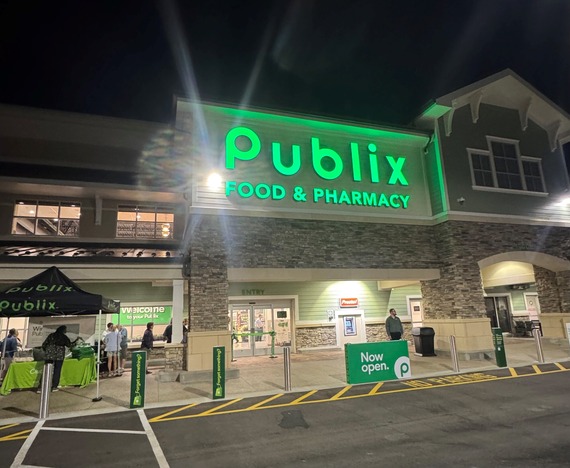
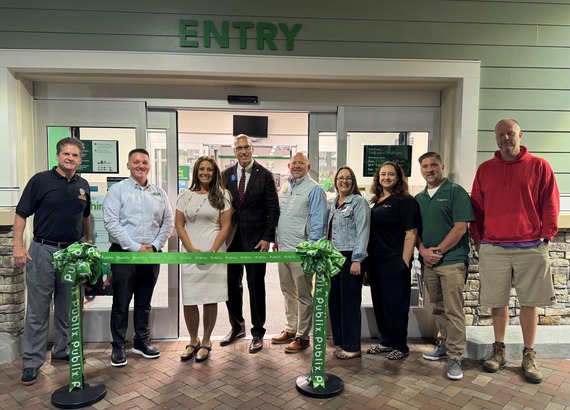
This Wednesday kicked off bright and early at 6:45 a.m. with a celebratory ribbon-cutting ceremony for Publix! We’re thrilled to officially welcome Publix to District 16. Their arrival brings even more variety to our local supermarket options, and we’re especially grateful for the jobs and positive economic impact they’ll have on our community.
-Scott

If you or anyone you know might be interested in applying, please scan the QR code below or contact Amanda Carpenter at 574-7016 or "amanda.carpenter@louisvilleky.gov" and start the process.

 You and your little ones are invited to join our Sippy Cup Strolls. Take part in a guided walk through the Louisville Zoo with maternal and child health professionals while you say hello to your favorite animals. Each session will focus on a different area of the Zoo.
Please RSVP for one of the dates and times:
- 9 a.m. to 11 a.m. Friday, September 12
- 9 a.m. to 11 a.m. October 25
Parking and admission for the day is included in your ticket.
For more information, please email healthystartevents@louisvilleky.gov
The Louisville Zoo is pleased to offer special discounts presented by Humana for Grandparents’ Day on September 7, 2025, and Senior Sundays on September 14, 21, and 28, 2025. These events are designed to celebrate and honor grandparents and seniors, providing them with unique opportunities to enjoy the Zoo with their families.
During both Grandparents’ Day and Senior Sundays, guests can participate in a special scavenger hunt focused on the Zoo’s animal grandparents and their important role in conservation. Additionally, Humana will host the “Humana Hydration Station” from 10 a.m. to 2 p.m. at the Glacier Run classroom, offering free water and cooling towels to help guests beat the heat (while supplies last).
Grandparents’ Day:
Celebrate Grandparents’ Day presented by Humana at the Zoo on Sunday, September 7, 2025. Guests can enjoy free admission for up to two seniors with the purchase of a regular-priced child or adult general admission ticket. Louisville Zoo members can also bring up to two seniors for free, making it a perfect day for family fun at the Zoo.
Senior Sundays in September:
Seniors ages 60 and older receive free admission to the Zoo on three special Sundays: September 14, 21, and 28, 2025, presented by Humana.
For more information on both of these events visit: https://louisvillezoo.org/events/
Zoo Hours:
The Zoo is open daily year-round. Now through September 21, 2025, Zoo hours are 10 a.m. ─ 5 p.m. (enjoy until 6 p.m.). Beginning September 22, 2025 – Mid March 2026, Zoo hours will be 10 a.m. – 4 p.m. (enjoy until 5 p.m.). The Zoo is closed on Thanksgiving, Christmas, and New Year’s Day. Visit louisvillezoo.org for more info.
New items or changes in project status are shown in bold
Inclement weather or other unforeseen circumstances may arise, and as such, the information provided below is for advisory purposes only and subject to change without prior notice.
| Jefferson County |
|
| I-65 Central Corridor |
Information related to the I-65 Central Corridor project can be found online at i65centralcorridor.com.
|
U.S. 31E (Main Street)
*Main Remade – East Phase |
***Construction phasing details, including traffic impacts, are available online at: www.MainRemade.com
Traffic Impacts: Sidewalk and lane closures are possible.
Date/Time: Daily.
Project Limits: U.S. 31E (Main Street) between Wenzel Street and 2nd Street.
Type of Work: One-way to two-way conversion. In addition to the new two-way configuration, other improvements coming to the corridor include upgrades to crosswalks and intersections, a protected bike lane, dedicated left-turn lanes, and new traffic signals.
|
| Old Eastern Parkway |
Traffic Impacts: Closure of Old Eastern Parkway.
Date/Time: Beginning Tuesday, Sept. 2, through Monday, Nov. 3.
Project Limits: Old Eastern Parkway between S. Floyd Street and S. Brook Street.
Type of Work: Maintenance project of the U.S. 60A (Eastern Parkway) bridge over S. Floyd Street.
Other Details: Traffic impacts are not expected to occur on the Eastern Parkway bridge while work is underway. |
| I-64 East and West |
Traffic Impacts: Westbound traffic is currently shifted from the outside shoulder to the inside lanes of the newly constructed bridge.
Date/Time: Daily/nightly.
Project Limits: I-64 East and West at mile point 11.799, near Exit 10 (Cannons Lane) on I-64 West, and near Exit 12 to I-264 (Watterson Expressway) on I-64 East.
Type of Work: Bridge replacement project.
Other Details: Project announcement press release
|
| I-65 North |
Traffic Impacts: Closure of the right two lanes.
Date/Time: Beginning at 7 p.m. Friday, Sept. 5, through 12 p.m. Sunday, Sept. 7.
Project Limits: I-65 North at mile point 123.5 (near the Jefferson/Bullitt County line).
Type of Work: Concrete slab repairs.
Other Details: Motorists should heed signage and use caution when traveling through the work zone. |
| I-65 South |
Traffic Impacts: Lane reduction and road closure.
Date/Time: Beginning Monday, Aug. 25, through December 2025.
Project Limits: I-65 South bridge at Exit 136C to Jefferson Street in downtown Louisville.
Type of work: Bridge maintenance project.
Other Details: During construction, the bridge will be reduced to a single 10-foot lane. Wide loads will not be permitted to use the ramp, and signage will be posted in advance to alert drivers of the restriction. In addition, South Floyd Street will be closed between East Jefferson Street and East Liberty Street. Drivers should follow the signed detour: East Liberty Street to South Jackson Street, left onto East Jefferson Street, and back to Liberty Street. Motorists are encouraged to plan ahead, follow posted signage, and use caution when driving through the work zone. |
| I-65 South (John F. Kennedy Memorial Bridge) |
Traffic Impacts: Closure of the right three lanes.
I-65 South (John F. Kennedy Memorial Bridge).
Type of Work: Expansion joint replacement project.
Other Details: The right three lanes and right shoulder of the bridge carrying I-65 South over the Ohio River will remain closed through the end of 2025 for ongoing construction activities. While lane closures span the entire length of the bridge, access to I-64 and I-71 will be maintained throughout the duration of the work.
*July 28, 2025 press release
*June 3, 2025 press release
*March 31, 2025 press release
*February 27, 2025 press release
|
| I-264/U.S. 42 (Brownsboro Road) Improvement Project |
*Traffic impacts available here.
|
| I-265 South (Gene Snyder Freeway) |
Traffic Impacts: Closure of the right lane.
Date/Time: Tuesday, Sept. 9, from 9 a.m. to 4 p.m.
Project Limits: The right lane of I-265 South (Gene Snyder Freeway) will be closed between mile markers 34 and 35 (near U.S. 42/Brownsboro Road).
Type of Work: Bridge deck repair.
Other Details: Motorists should heed signage and use caution when traveling through the work zone. |
| KY 841 (Gene Snyder Freeway) |
Traffic Impacts: Single lane closures are possible.
Date/Time: Beginning Sunday, Sept. 7, through Saturday, Sept. 13.
Daily – 9 a.m. to 3 p.m. | Nightly – 7 p.m. to 5 a.m.
Project Limits: KY 841 North and South (Gene Snyder Freeway), between mile points 35.0 and 37.7, near and through the East End Tunnel.
Type of Work: Routine maintenance of the roadway and East End Tunnel.
Other Details: Motorists should heed signage, use caution, and adjust commutes to accommodate lane closures. |
| KY 864 (Logan Street/Shelby Street) |
Traffic Impacts: Sidewalk and lane closures are possible.
Date/Time: Daily and nightly.
Project Limits: Between Goss Avenue and East Gray Street.
Type of Work: One-way to two-way conversion of the roadway.
Other Details: Major work has resumed, with full completion expected by the Spring of 2026.
*The traffic signals at Logan/Mary, Logan/Breckinridge, Logan/Oak, Shelby/Breckinridge are currently set to flash for STOP conditions. On Sept. 1, 2025, the signals are scheduled to be activated. Motorists should use caution and adhere to the temporary traffic pattern. |
| KY 1819 (Billtown Road) |
Traffic Impacts: Lane closures and delays are possible.
Date/Time: Daily – 9 a.m. to 4 p.m.
Project Limits: Three sections of KY 1819 (Billtown Road):
- Easum Road through Mary Dell Lane
- Michael Edward Drive through Fairground Road
- Shady Acres Lane through Colonnades Place
Type of Work: Reconstruction of KY 1819 (Billtown Road) from north of Colonnades Place to south of Easum Road with new traffic signals, signal optimization, turn lanes, storage lanes, etc. (varying by intersection based on existing conditions and future traffic projections).
Other Details: The reconstruction project is expected to be completed by the Fall of 2025.
*Project webpage
|
| Ky 3084 (Old Henry Road) |
Traffic Impacts: Road closure.
Date/Time: Monday, Sept. 8, from 9 a.m. to 8 p.m.
Project Limits: KY 3084 (Old Henry Road) between Reamers Lane and Factory Lane.
Type of Work: Bridge overlay.
Other Details: Motorists should follow posted detours, use caution, and plan for increased travel times. |
I-264
*Various Exit Ramps |
Traffic Impacts: Ramp narrowing with intermittent lane and shoulder closures.
Project Limits: Various interchange Exit ramps on I-64 and I-264.
Type of Work: Installation and upgrade of wrong-way pavement markings and signs.
Other Details: The Highway Safety Improvement Project will install and enhance wrong-way signs and pavement markings on interstate Exit ramps to discourage wrong-way driving. Motorists should reduce speeds and obey traffic control while workers are present. This project is expected to be completed by the Fall of 2025. |
| |
|
| Bullitt County |
|
| I-65/KY 480 (Cedar Grove Road) |
Traffic Impacts: Changing traffic patterns, lane shifts, and lane closures are possible as final construction activities are underway.
Date/Time: Daily and nightly.
Project Limits: KY 480 (Cedar Grove Road) between I-65 (mile points 0.6 and 1.4).
Type of Work: Reconstruction of the KY 480/I-65 interchange, including the construction of a double crossover diamond.
Other Details: The interchange reconstruction project is now in its final configuration. The project is expected to be completed by the Fall of 2025.
|
| |
|
| Franklin County |
|
| KY 12 |
Traffic Impacts: N/A.
Date/Time: Beginning Aug. 11, through Dec. 1.
Project Limits: KY 12 bridge over Flat Creek at mile point 12.46 (at the Franklin/Henry County line).
Type of Work: Bridge replacement project.
Other Details: Traffic will be maintained on the existing bridge until construction has been completed on the replacement bridge. |
| U.S. 60 (Louisville Road) |
Traffic Impacts: Lane closures are possible.
Date/Time: Daily.
Project Limits: U.S. 60 (Louisville Road) from mile point .023 to mile point 3.89.
Type of Work: Base failure repairs ahead of an upcoming asphalt resurfacing project.
Other Details: Motorists should heed signage, use caution, and expect delays. |
| I-64 East and West |
Traffic Impacts: Lane closures and traffic shifts are possible.
Date/Time: Daily/nightly beginning Thursday, Sept. 4.
Project Limits: The I-64 East and West, between the Frankfort exits (mile markers 53 and 58).
Type of Work: The I-64 improvement project, between the Frankfort exits (mile markers 53 and 58), includes the milling and removal of the existing asphalt surface followed by resurfacing with new asphalt pavement. Other improvements to the 5-mile corridor include bridge repairs and bridge crash wall repairs.
Other Details:
- Westbound I-64:
- Beginning Thursday, Sept. 4, at 7 p.m., through Sunday, Sept. 14, the left lane of I-64 West near U.S. 60 at mile marker 57 will be closed.
- Beginning Sunday, Sept. 14, at 7 a.m., through Wednesday, Sept. 24, the right lane of I-64 West near U.S. 60 at mile marker 57 will be closed.
- Eastbound I-64:
- Beginning Wednesday, Sept. 24, at 7 p.m., through Saturday, Oct. 4, the left lane of I-64 East near U.S. 60 at mile marker 57 will be closed.
- Beginning Saturday, Oct. 4, at 7 p.m., through Tuesday, Oct. 14, the right lane of I-64 East near U.S. 60 at mile marker 57 will be closed.
|
| U.S. 127/Vandalay Drive Intersection |
Traffic Impacts: Lane closures and traffic shifts are possible.
Date/Time: Daily/nightly.
Project Limits: U.S. 127/Vandalay Drive intersection.
Type of Work: The scope of the project includes constructing a new roundabout at the intersection of Vandalay Drive and Westridge Drive; extending Vandalay Drive to Limestone Drive to create a direct connection to KY 676 (East-West Connector); extending Vandalay Drive to U.S. 127 near the I-64/U.S. 127 interchange; and adding dual receiving lanes to improve left-turn movements from U.S. 127 onto Westridge Drive.
Other Details: The project is scheduled to be completed by the summer of 2026. |
| KY 1665 (Bridgeport-Benson Road) |
Traffic Impacts: Closure.
Date/Time: Beginning Monday, July 7, through Sunday, Sept. 7.
Project Limits: KY 1665 (Bridgeport-Benson Road) bridge over South Benson Creek at mile point 3.93.
Type of Work: Bridge replacement. |
| |
|
| Oldham County |
|
| KY 53 (North First Avenue) |
Traffic Impacts: Lane closures and restricted street parking.
Date/Time: Nightly – 6 p.m. to 6 a.m. beginning Sunday, Aug. 17, through Sunday, Aug. 24.
Project Limits: KY 53 (North First Avenue) beginning at KY 146 and extending north to U.S. 42 at mile point 11.045.
Type of Work: Asphalt resurfacing.
|
| |
|
| Spencer County |
*Routine maintenance* |
| KY 1633 (Elk Creek Road) |
Traffic Impacts: Road closure.
Date/Time: Tuesday, Sept. 9, from 6 p.m. to midnight.
Project Limits: KY 1633 (Elk Creek Road) at mile point 0.3 (near the KY 1633/KY 44 intersection).
Type of Work: Cross drain replacement. ` |
| |
|
| Shelby County |
|
| I-64 Widening and Improvement Project |
*Traffic impacts here.
|
| U.S. 60 (Frankfort Road) |
Traffic Impacts: Lane closures are possible.
Date/Time: Daily.
Project Limits: U.S. 60 (Frankfort Road) from mile point 19.338 at KY 395 to mile point 23.0 at the Franklin/Shelby County line.
Type of Work: Base failure repairs ahead of an upcoming asphalt resurfacing project.
Other Details: Motorists should heed signage, use caution, and expect delays. |
| |
|
| Henry County |
*Routine maintenance* |
| |
|
| Trimble County |
*Routine maintenance* |
2025 Resurfacing Projects
Resurfacing projects will begin April 1, 2025, and will be completed by the Fall of 2025.
Motorists should heed signage and use caution when traveling through the work zone.
| County / Road Name: |
Project Limits: |
| Jefferson County |
|
| U.S. 60 (Shelbyville Road) |
Begin at an asphalt joint west of U.S. 60A extending east to 53 ft west of Sherburn Ln Spur Conn/Ten Pin Ln, a distance of 01.85 miles |
| U.S. 60 (Shelbyville Road) |
Begin at Urton Lane/North English Station Road, extending east to an asphalt joint 0.038 miles west of Beckley Woods Drive/English State Way. |
U.S. 31 (West Main Street)
|
West Main St (US 31W southbound only) begins at US 150/West Main St, extending south to 145 ft north of US 31, a distance of 1.78 miles. |
| KY 907 (Valley Station Road/Third Street Road) |
Begin at U.S. 31E extending north to Arnoldtown Road, a distance of 3.99 miles |
| KY 1065 (Outer Loop) |
Begin at KY 907 extending east to a concrete joint at KY 1020, a distance of 02.48 miles |
| KY 61 (Preston Highway) |
Begin at the north end of the bridge over I-265 extending north to 0.026 miles south of Okolona Ter, a distance of 01.86 miles |
KY 1230 (Lower River Road)
|
From Tennis Blvd, west 0.093 miles, extending northerly to KY 1934, a distance of 2.62 miles. |
KY 2830 (Arthur Street)
*Completed* |
KY 2830 (Arthur Street) east of Brandies Avenue/KY 61 extending north to University Boulevard. |
U.S. 31E (Bardstown Road)
*Completed* |
U.S. 31E (Bardstown Road) at the Bullitt/Jefferson County line, extending south of Colonel Hancock Drive. |
KY 1631 (Crittenden Drive)
*Completed* |
KY 1631 (Crittenden Drive) at the beginning of state maintenance near the I-264 interchange, extending north to U.S. 60A (Eastern Parkway). |
KY 1531 (Johnson Road)
*Completed* |
KY 1531 (Johnson Road) from the railroad crossing extending north to Aiken Road. |
KY 61 (Arthur Street)
*Completed* |
KY 61 (Arthur Street) beginning east of Brandies Avenue extending north to I-65 ramp/East Gaulbert Avenue. |
KY 155 (Taylorsville Road)
*Completed* |
KY 155 (Taylorsville Road) beginning at KY 1747 (Hurstbourne Lane) extending north to KY 1932 (Breckenridge Lane). |
KY 329 (Covered Bridge Road)
*Completed* |
KY 329 (Covered Bridge Road) beginning at U.S. 42 extending east to the Jefferson/Oldham County line. |
| |
|
| Bullitt County |
|
KY 61 (Old Preston Highway)
|
Begin at KY 61 extending north to 0.165 miles north Hillsbrook Dr, a distance of 0.87 miles
|
KY 61 (North Preston Highway)
|
Begin 21 ft north of KY 2553 extending north to Bullitt/Jefferson County line, a distance of 01.58 miles
|
| KY 480 (Cedar Grove Road) |
Begin 0.113 miles east of Park Loop Rd/Valley Vw Dr extending east to 0.077 miles east of KY 1442, a distance of 0.42 miles |
KY 1442 (Ridge Road)
|
Ridge Rd/Clarks Ln from McCubbins Farm Ln, south 0.056 mile, extending easterly towards Paddock Rd, a distance of 4.90 miles. |
KY 1604 (Deatsville Road)
|
From KY 245, extending northerly towards Jackson Hollow Rd, a distance of 3.20 miles. |
KY 1531 (Dawson Hill Road)
*Completed* |
KY 1531 (Dawson Hill Road) from KY 1319 extending north to the Bullitt/Jefferson County line. |
KY 2672 (Knob Creek Road)
*Completed* |
KY 2672 (Knob Creek Road) from KY 1526 (Brooks Hill Road) extending north towards Lake Elmo Road. |
KY 2674 (Stringer Lane)
*Completed* |
KY 2674 (Stringer Lane) from U.S. 31E extending north to KY 44. |
| |
|
| Franklin County |
|
| U.S. 60 (Louisville Road) |
Begin at the east end of Benson Creek Bridge extending east to mile point .025 just east of Office Park Drive. |
| KY 12 (Dry Ridge Road/Flat Creek Road) |
KY 12 (Dry Ridge Road/Flat Creek Road) from the Shelby/Franklin County line extending east to Harvieland Road. |
| KY 1570 (St Johns Road) |
KY 1570 (St Johns Road) from the bridge at mile point 4.2, extending north to KY 12. |
| U.S. 127 (Wilkinson Boulevard) |
U.S. 127 (Wilkinson Boulevard) near Hall Street extending north to the south end of the U.S. 127/KY 2261 bridge. |
| |
|
| Oldham County |
|
| KY 53 (North First Avenue) |
Begin at KY 146 extending north to US 42 (MP 11.045), a distance of 03.99 miles |
KY 524 (Westport Road)
|
From US 42, extending northerly towards Smith Ln, a distance of 1 mile. |
KY 362 (Central Avenue)
*Completed* |
KY 362 (Central Avenue) from Rosswoods Drive extending south towards KY 146. |
KY 329 (Covered Bridge Road)
*Completed* |
KY 329 (Covered Bridge Road) from KY 329B extending east to mile point 8.754. |
| KY 393 (Crestwood to La Grange) |
Begin at KY 22 extending north to the south end of the North Fork Bridge, a distance of 1.99 miles |
KY 393 (Payton Lane)
|
From KY 1818, extending northerly to KY 22, a distance of 2.56 miles. |
KY 1694 (Gum Street)
*Completed* |
KY 1694 (Gum Street) from KY 329 extending north towards Mason Lane. |
KY 3223 (Old Sligo Road)
|
From KY 53, extending northerly to Ballard School Rd, a distance of 1.55 miles. |
U.S. 42
*Completed* |
U.S. 42 east of KY 1694 (Gum Street) extending east to the Oldham/Henry County line. |
| |
|
| Shelby County |
|
U.S.421 (Castle Highway)
|
Begin 21 feet north of KY 3322 extending north to KY 55, a distance of 2.82 miles. Castle Highway begins at Henry/Shelby County line extending north to the Shelby/Henry County line, a distance of 0.79 mile. |
KY 22 (Ballardsville Road)
|
Begin at Oldham/Henry County line extending east to KY 55, a distance of 7.02 miles |
KY 362 (Aiken Road)
*Completed* |
KY 362 (Aiken Road) from the Oldham/Shelby County line extending east near Webb Road. |
| U.S. 60 (Frankfort Road) |
U.S. 60 (Frankfort Road) beginning at KY 395 extending east to the Shelby/Franklin County line. |
KY 1408 (Loydsburg Road)
*Completed* |
KY 1408 (Loydsburg Road) from KY 362 extending west to the Shelby/Oldham County line. |
KY 322 (Lucas Road)
*Completed* |
KY 322 (Lucas Road) from KY 53 extending north to the Shelby/Henry County line. |
KY 53 (Mt. Eden Road)
*Completed* |
KY 53 (Mt. Eden Road) beginning at KY 714/KY 44 extending north to KY 1790 (Hooper Station Road). |
| |
|
| Spencer County |
|
KY 1392 (Grays Run Road)
*Completed* |
Begin at the east end of Simpsonville Creek Bridge extending east to KY 55, a distance of 2.64 miles |
KY 1633 (Elk Creek Road)
*Completed* |
KY 1633 (Elk Creek Road) from KY 1135 (Industrial Road) extending north to KY 55.
|
KY 1795 (Mill Road)
*Completed* |
KY 1795 (Mill Road) from Paradise Pointe Road extending east to KY 636. |
KY 55 (Shelbyville Road)
*Completed* |
KY 55 (Shelbyville Road) beginning at KY 155 extending north to the Spencer/Shelby County line. |
| |
|
| Henry County |
|
U.S.421 (Castle Highway)
|
Begin 21 feet north of KY 3322 extending north to KY 55, a distance of 2.82 miles. Castle Highway begins at Henry/Shelby County line extending north to the Shelby/Henry County line, a distance of 0.79 mile. |
U.S. 421 (Campbellsburg Road)
*Completed* |
U.S. 421 (Campbellsburg Road) at the I-71 overpass extending to the Henry/Trimble County line. |
KY 22 (Ballardsville Road)
|
Begin at Oldham/Henry County line extending east to KY 55, a distance of 7.02 miles
|
KY 1360 (Franklinton Road)
*Completed* |
KY 1360 (Franklinton Road) from KY 22 extending north to Bullitt Hill Road.
|
KY 241 (Pleasureville Road)
*Completed* |
KY 241 (Pleasureville Road) beginning at the Shelby/Henry County line extending north to U.S. 421. |
KY 1861 (Smithfield Road)
*Completed* |
KY 1861 (Smithfield Road) from KY 22 extending to KY 322. |
| |
|
| Trimble County |
|
KY 1256 (Fisher Ridge Road)
*Completed* |
KY 1256 (Fisher Ridge Road) from Detmer Lane extending east to KY 625. |
KY 3175 (Sulphur-Bedford Road)
*Completed* |
KY 3175 (Sulphur-Bedford Road) from Hoskins Lane extending north to U.S. 42. |
We now have a new way for you to map crime around you. Just click here and view our new interactive crime mapping tool for Division 5 & 8 or for each beat in Division 5 & 8. And save it in your favorites to view crime anytime it's updated daily. On the page is a Quickfind tool that allows you to put your address in and subscribe to crime trends, alerts and block watch reports for your police beat. Forward this email to your friends and family!
For further information on Councilman Scott Reed or District 16 please visit www.louisvilleky.gov/government/metro-council-district-16
You can also reach out directly by phone at 502.574.1116 or by email at scott.reed@louisvilleky.gov.
601 West Jefferson Street
Louisville, KY 40202
Having Trouble Viewing this eNewsletter? Click here to view it on the web.
|