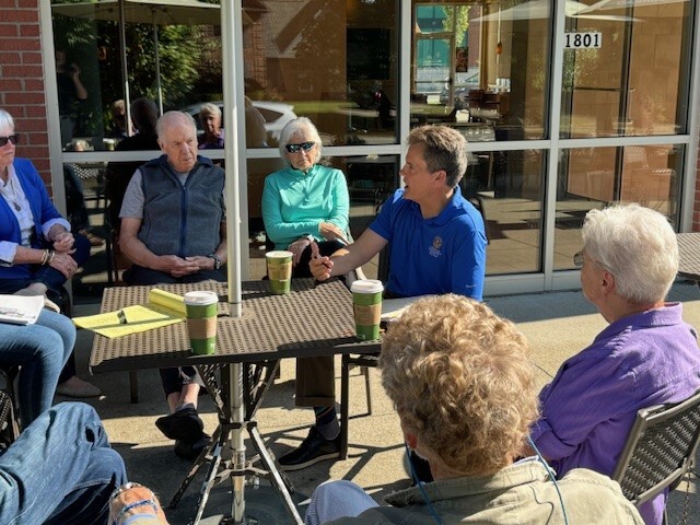
 Please be advised of a Coffee with Your Councilman event Saturday, June 7th from 10:00 am to 11:00 am at Rudy Lane Panera Bread, 1801 Rudy Ln, Louisville, KY 40207.
Come meet Councilman Reed in a relaxed setting and provide suggestions or ask questions about District 16, annual budget process, local policy, or the larger community.
WHEN: Saturday, June 7th from 10:00 am to 11:00 am
WHERE: Panera Bread, 1801 Rudy Ln, Louisville, KY 40207
If you have any questions, please contact the District 16 office at 574-1116 or email my Legislative Assistant Jared Townes at Jared.Townes@Louisvilleky.gov.
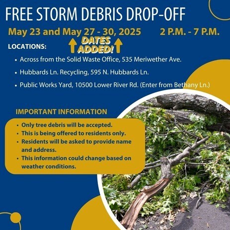
Today, May 23 AND May 27-30
🕑 2:00 p.m. – 7:00 p.m.
📍 Drop-Off Locations:
Across from Solid Waste Office — 535 Meriwether Ave.
Hubbards Ln Recycling Location — 595 Hubbards Ln.
Public Works Yard — 10500 Lower River Rd. (Enter from Bethany Ln.)
⚠️ Important Information:
Tree debris only will be accepted.
Residents only — no commercial drop-offs.
Please be prepared to provide your name and address.
Schedule and details are subject to change based on weather conditions.
You are invited to attend a review for a CONDITIONAL USE PERMIT to allow short term rental of a dwelling unit that is not the primary residence of the owner.
Este es un aviso para una audiencia publica relacionada con una solicitud en la propiedad que se enumera a continuacion. Para obtener mas informacion, o para servicios de traduccion, escanee el codigo QR que aparece arriba o llame al (502) 574-6230.
Subject Property(Propiedad Sujeta): 901 Blankenbaker Lane
Case Number (Numero de Caso): 25-CUP-0085
Case manager (Administradora de Casos): Zach Schwager (Zach.Schwager@louisvilleky.gov)
Meeting Type(Tipo De Reunion): Board of Zoning Adjustment
Meeting Date (Fecha De La Reunion) Monday, June 2, 2025
Time (Tiempo): Meeting will begin at 1:00 PM and continue until all cases are heard
Location (Ubicacion de Reunion): 514 W Liberty Street, 40202 (Old Jail Building)
Please review the meeting agenda and case material, including the staff report, here:
https://louisvilleky.primegov.com/public/portal
To join the meeting virtually, please visit:
https://louisvilleky.gov/government/office-planning/upcoming-publiic-meetings
To view all case documents, visit https://aca-prod.accela.com/LJCMG or:
Louisville Metro Office of Planning
444 S. 5th Street, 3rd Floor, Louisville, KY 40202
(Hours: 8:00AM to 5:00PM).
Phone: (502) 574-6230 Question? Ask our staff!
If you wish to submit comments in writing on this case, please submit to the case manager by 9:00 A.M. Friday, May 30, 2025. If you would like to provide verbal testimony, please attend the meeting or participate online.
Persons who desire special accommodations, including translation or interpretation services, should contact the Office of Planning at (502) 574-6230 at least one week prior to this meeting.
Officers responded to the area of Hunting Creek and Scenic Hill on May 17, 2025, at 5:44 am, when a resident reported several suspects in black tracksuits entering their vehicle and opening their garage door. The suspects fled in a white Infiniti sedan when the homeowner discovered them. Prospect Officers were in the area in less than 2 minutes and observed the suspect vehicle at US 42 and Fox Harbor fleeing the area at high speed. Officers did not engage in pursuit operations because of the reckless actions of the suspect and the unnecessary risk a vehicle pursuit creates for innocent bystanders. Similar incidents were reported to the Police on Hunting Creek Drive and Hunting Green Drive. None of the vehicles showed any signs of forced entry.
Remember to lock your vehicles and remove any valuables.
Questions and comments can be directed to citycops@prospectky.gov
Use the Ring Neighbors app to get notifications from Prospect Police about criminal activity in your area.
https://ring.com/neighbors?srsltid=AfmBOormmNQJx8FosuU-Fb_48ey322qnl20Ox-b4HilNA5Y2nkaGoHQl
 Memorial Day, Monday, May 26 A free Metro event!
Join Mayor Craig Greenberg for the Memorial Day Hike, Bike & Paddle
HIKE!
This year’s Hike will consist of a 4-mile walk with multiple marked turnaround points throughout. Travel from the Great Lawn and follow the Ohio River east to RiverPark Place and back. The furthest distance will cross the Big Four Bridge into Indiana and come back.
BIKE!
Participants can bike through downtown Louisville. The 1st 300 people who participate will get a New Bike Helmet courtesy of the Brain Injury Alliance of Kentucky. Check out the bike course below for the detailed route.
PADDLE!
Paddlers will have the option of launching at the Harbor Lawn or the U of L Boat Docks and paddle downstream to meet the other paddlers. This year’s paddle will go from the Harbor Lawn downriver to the McAlpine Locks, through the locks and to the Shawnee Park Boat Ramp. This year participants can rent a limited number of kayaks for FREE. Kayaks and all required equipment will be available on a first come first serve basis. Participants will have to sign a waiver and get instructed on water safety. Come to the event early and find a Shack Yaks trailer to secure your reservation.
Paddle Boards are allowed at the Mayor's Hike, Bike, & Paddle! The paddle boarders will need to completely step off their boards and onto one of the rescue boats when going through the McAlpine locks before we can lock the group down. No sitting down on the board is allowed, paddle boarders must be on the boat. Every single person will be required to wear a life jacket even if they are on a boat. All paddlers must wear a life vest. Paddles without a vest will not be permitted to go through the McAlpine Locks.
GET ACTIVE!
Beginning at 8 a.m., there will be plenty of fun, music, and free fitness activities for you to enjoy. Get involved in activities like Yoga, Step Aerobics, Zumba, and High-intensity warm-up Fitness classes, and Workout circuits to celebrate Memorial Day weekend.
FREE t-shirts are available to the first 2,000 people. The t-shirt tent will open at 8:00 a.m., so make sure to arrive promptly to get in line! The Hike, Bike, and Paddle portions will starts at 10a.m.
Interested in getting involved? Email jaleyah@JWagnerGroup.com
For volunteer opportunities, please email Dorian at Dorian@JWagnerGroup.com

BBB serving Greater Kentucky and South Central Indiana warns of storm-chasing scammers in the aftermath of the weekend’s devastating tornadoes and storms.
With any destructive and severe weather, there is an increased potential of out-of-town storm chasers looking to take advantage of victims as they begin the process of cleaning up and repairing property damage. BBB warns residents affected by the storms to beware of these scammers.
BBB offers the following tips for storm victims:
- Know your rights and responsibilities as provided by the state Attorney General. Kentucky residents can contact the Kentucky Attorney General’s office at ag.ky.gov or call 502.696.5300.
- Businesses must be licensed. Contact the Revenue Commission at 502.574.4860 to check out a company’s licensure.
- Many municipalities require a solicitation permit if salespeople go door-to-door. Verify that they need to have a permit by contacting your local Township or Municipality or call Permits & Licensing at 502.574.3321
- While most roofing contractors abide by the law, be careful allowing someone you do not know to inspect your roof. An unethical contractor may actually create damage to get work.
- Try to get at least 3-4 quotes from contractors, and insist that payments be made to the company, not an individual.
- Do not pay for the job in advance. Be wary of any contractor who demands full or half payment upfront.
- Resist high-pressure sales tactics, such as the “good deal” you’ll get only if you hire the contractor on the spot.
- Get a written contract that specifies the price, the work to be done, the amount of liability insurance coverage maintained by the contractor, and a time frame. Require a copy of their current certificate of insurance.
- For general questions or complaints related to insurance, contact your state’s Department of Insurance. Kentucky residents can visit insurance.ky.gov or call 502.564.3630.
- Pay by credit card, if possible; you may have additional protection if there’s a problem.
- If you suspect a company may be price gouging necessary goods or services due to the area storm damage, report the business to BBB and the Attorney General’s office.
- Beware of FEMA imposters. In the past, scammers have impersonated FEMA to try to scam consumers. Remember that FEMA does not charge for inspections, and they always wear ID badges. If you are still unsure, check with FEMA first at fema.gov or call 202.646.2500.
BBB is also warning area contractors to beware of storm chasers who are willing to pay local construction companies substantial amounts of money to use a local business’s established name, reputation, and phone so they can masquerade as a local business. Many contractors who agreed to let these storm chasers use their name regret their decision once they were left holding the bag of unsatisfied customers due to bad workmanship and/or unfulfilled warranties.
Finally, BBB advises consumers to be wary of any scam callers masquerading as gas and electric company employees. LG&E and KU will never call consumers and demand payment immediately over the phone in order to restore power (or prevent it from being shut off). For any concerns regarding utilities, contact your provider directly. Do not give your financial information over the phone to any unsolicited caller.
 Sunday, June 8th
Lynn Family Stadium
The Buy Local Fair features local and independent businesses, including food and drink vendors, artists and makers, services and more!
Interested in being a vendor or sponsor? More info here. (Must be a LIBA business member.)
Interested in volunteering? More info here.

LOUISVILLE, Ky. (May 23, 2025) – The Kentucky Transportation Cabinet (KYTC) advises motorists of lane closures on Interstate 64 and Interstate 71 beginning Tuesday, May 27, as part of the I-Move KY project. Details regarding the upcoming traffic impacts are below.
Tuesday, May 27, from 8 p.m. to Wednesday, May 28, at 6 a.m.:
- I-71 North will be reduced to one lane from mile marker 13 (near the I-71 Rest Area) to mile marker 14 (near KY 329) in Oldham County.
- I-64 East will be reduced to one lane at the I-64/I-265 (Gene Snyder Freeway) interchange in Jefferson County.
Wednesday, May 28, from 8 p.m. to Thursday, May 29, at 6 a.m.:
- I-64 East will be reduced to one lane near mile marker 17 (near KY 913/Blankenbaker Parkway) in Jefferson County.
- I-64 West will be reduced to one lane at the I-64/I-265 (Gene Snyder Freeway) interchange in Jefferson County.
Thursday, May 29, from 8 p.m. to Friday, May 30, at 6 a.m.:
- I-64 East and West will be reduced to one lane at the I-64/I-265 (Gene Snyder Freeway) interchange in Jefferson County.
Drivers should plan for increased travel times, heed signage, and use caution when traveling through the work zones.
New items or changes in project status are shown in bold
Inclement weather or other unforeseen circumstances may arise, and as such, the information provided below is for advisory purposes only and subject to change without prior notice.
| I-Move KY |
|
| I-265 (Gene Snyder Freeway) |
Tuesday, May 27, from 8 p.m. to Wednesday, May 28, at 6 a.m.:
- I-71 North will be reduced to one lane from mile marker 13 (near the I-71 Rest Area) to mile marker 14 (near KY 329) in Oldham County.
- I-64 East will be reduced to one lane at the I-64/I-265 (Gene Snyder Freeway) interchange in Jefferson County.
Wednesday, May 28, from 8 p.m. to Thursday, May 29, at 6 a.m.:
- I-64 East will be reduced to one lane near mile marker 17 (near KY 913/Blankenbaker Parkway) in Jefferson County.
- I-64 West will be reduced to one lane at the I-64/I-265 (Gene Snyder Freeway) interchange in Jefferson County.
Thursday, May 29, from 8 p.m. to Friday, May 30, at 6 a.m.:
- I-64 East and West will be reduced to one lane at the I-64/I-265 (Gene Snyder Freeway) interchange in Jefferson County.
|
| Jefferson County |
|
| I-64 East and West |
Traffic Impacts: Lane closures and traffic shifts are possible.
Date/Time: Daily and nightly.
Project Limits: I-64 East and West at mile point 11.799, near Exit 10 (Cannons Lane) on I-64 West, and near Exit 12 to I-264 (Watterson Expressway) on I-64 East.
Type of Work: Bridge replacement project.
Other Details: **Eastbound and westbound traffic is shifted to the outer shoulders. Construction is currently taking place in the median, and two 11-foot lanes will remain open in each direction for the duration of the project.
*Press release
|
| I-65 South (John F. Kennedy Memorial Bridge) |
Date/Time: Once expansion joints have been fabricated as part of the expansion joint replacement project, additional details regarding the project's timing will be shared.
Project Limits: I-65 South (John F. Kennedy Memorial Bridge).
Other Details: The project is expected to be completed by April 2026, and intermittent lane closures are to be anticipated throughout the duration of construction.
*March 31, 2025 press release
*February 27, 2025 press release
|
| KY 864 (Logan Street/Shelby Street) |
Traffic Impacts: Sidewalk and lane closures are possible.
Date/Time: Daily and nightly.
Project Limits: Between Goss Avenue and East Gray Street.
Type of Work: One-way to two-way conversion of the roadway.
Other Details: Work is underway ahead of asphalt resurfacing and the two-way conversion of the roadway.
*Work was temporarily paused on this project as KYTC engineers coordinated with contractors and utility providers to reduce utility conflicts along the corridor. Major work is expected to resume this Spring, with full completion expected by the Spring of 2026. |
| KY 1819 (Billtown Road) |
Traffic Impacts: Lane closures and delays are possible.
Date/Time: Daily – 9 a.m. to 4 p.m.
Project Limits: Three sections of KY 1819 (Billtown Road):
- Easum Road through Mary Dell Lane
- Michael Edward Drive through Fairground Road
- Shady Acres Lane through Colonnades Place
Type of Work: Reconstruction of KY 1819 (Billtown Road) from north of Colonnades Place to south of Easum Road with new traffic signals, signal optimization, turn lanes, storage lanes, etc. (varying by intersection based on existing conditions and future traffic projections).
Other Details: The reconstruction project is expected to be completed by the Summer of 2025.
*Project webpage
|
| Clark Station Road |
Traffic Impacts: Road/bridge closure.
Project Limits: Clark Station Road Bridge over Long Run Creek.
Type of Work: Bridge replacement project.
Other Details: Construction will require the full closure of the existing bridge through August 1, 2025. |
| South Pope Lick Road |
Traffic Impacts: Full closure of the bridge.
Date/Time: Beginning Wednesday, May 7, through Friday, June 6.
Project Limits: The South Pope Lick Road bridge over I-265 (Gene Snyder Freeway), between Poplar Lane and Tucker Station Road.
Type of Work: Bridge deck restoration and latex overlay.
Detour: Motorists are advised to follow the signed detour route: Pope Lick Road to Tucker Station Road, then to Plantside Drive and Rehl Road, before rejoining Pope Lick Road.
Other Details:
*During preliminary work, contract crews identified additional deterioration on the bridge's deck that was visually obstructed prior to work beginning. The scope of the project has been updated, thus requiring the full closure of the bridge for 30 days. |
| I-64 and I-264 *Various Exit Ramps |
Traffic Impacts: Ramp narrowing with intermittent lane and shoulder closures.
Project Limits: Various interchange Exit ramps on I-64 and I-264.
Type of Work: Installation and upgrade of wrong-way pavement markings and signs.
Other Details: The Highway Safety Improvement Project will install and enhance wrong-way signs and pavement markings on interstate Exit ramps to discourage wrong-way driving. Motorists should reduce speeds and obey traffic control while workers are present. This project is expected to be completed by the Fall of 2025. |
| |
|
| Bullitt County |
|
| I-65/KY 480 (Cedar Grove Road) |
Traffic Impacts: Changing traffic patterns, lane shifts, and lane closures are possible as construction progresses.
Date/Time: Daily and nightly.
Project Limits: KY 480 (Cedar Grove Road) between I-65 between mile points 0.6 and 1.4.
Type of Work: Reconstruction of the KY 480/I-65 interchange, including the construction of a double crossover diamond.
Other Details: The interchange reconstruction project is expected to be completed by the Fall of 2025.
|
| I-65 *Various Exit Ramps |
Traffic Impacts: Intermittent lane and ramp closures.
Date/Time: Nightly – 8 p.m. to 6 a.m. | Daily – 9 a.m. to 3 p.m.
Project Limits: Various interchange Exit ramps on I-65.
Type of Work: Upgrade and install wrong way pavement markings and signs.
Other Details: The Highway Safety Improvement Project will install and enhance wrong way signs and pavement markings on various interstate exit ramps to discourage wrong way driving. Motorists should reduce speeds and obey traffic control while workers are present. This project is set to be completed by the fall of 2025. |
| |
|
| Franklin County |
|
| I-64/U.S. 127 Interchange |
Traffic Impacts: Lane closures and traffic shifts are possible.
Date/Time: Nightly.
Project Limits: The I-64/U.S. 127 interchange.
Type of Work: The realigning of the I-64 West off-ramp to U.S. 127 North and the I-64 West on-ramp from U.S. 127. Other improvements include the installation of a new signalized intersection on U.S. 127 to provide access to development entrances, which will be activated following project completion. Additionally, the intersection of Westridge Drive and Leonardwood Drive will be reconstructed to accommodate dual left turns onto Westridge Drive from U.S. 127.
Other Details: Traffic is now in its final configuration. The interchange reconstruction project is expected to be completed by the Summer of 2025.
*Press release
|
| I-64 *Various Exit Ramps |
Traffic Impacts: Intermittent lane and ramp closures.
Date/Time: Nightly – 8 p.m. to 6 a.m. | Daily – 9 a.m. to 3 p.m.
Project Limits: Various interchange Exit ramps on I-64.
Type of Work: Upgrade and install wrong way pavement markings and signs.
Other Details: The Highway Safety Improvement Project will install and enhance wrong way signs and pavement markings on various interstate exit ramps to discourage wrong way driving. Motorists should reduce speeds and obey traffic control while workers are present. This project is set to be completed by the fall of 2025. |
| |
|
| Oldham County |
|
| I-71 *Various Exit Ramps |
Traffic Impacts: Intermittent lane and ramp closures.
Date/Time: Nightly – 8 p.m. to 6 a.m. | Daily – 9 a.m. to 3 p.m.
Project Limits: Various interchange Exit ramps on I-71.
Type of Work: Upgrade and install wrong way pavement markings and signs.
Other Details: The Highway Safety Improvement Project will install and enhance wrong way signs and pavement markings on various interstate exit ramps to discourage wrong way driving. Motorists should reduce speeds and obey traffic control while workers are present. This project is set to be completed by the fall of 2025. |
| |
|
| Spencer County |
*Routine maintenance* |
| |
|
| Shelby County |
|
| I-64 Widening and Improvement Project |
*Traffic impacts here.
|
| |
|
| Henry County |
|
| *Various Locations |
Traffic Impacts: Lane closures and delays are possible as part of a mobile operation.
Date/Time: Daily – 7 a.m. to 9 p.m.
Type of Work: Pavement striping.
Other Details: Motorists should provide plenty of space to crews displaying "WET PAINT" signage and be observant of slowed vehicles while traveling through the work zone. |
| |
|
| Trimble County |
|
| U.S. 421 |
Traffic Impacts: Road closure.
Date/Time: Beginning Monday, June 2, through Friday, June 13.
Project Limits: U.S. 421 from mile point 0.0 (at the Trimble/Henry County line) to mile point 6.704 (at the U.S. 42/U.S. 421 intersection).
Type of Work: KYTC crews will repair a roadway slide caused by recent heavy rainfall. Crews will also address base failures and implement slope protection measures.
|
| *Various Locations |
Traffic Impacts: Lane closures and delays are possible as part of a mobile operation.
Date/Time: Daily – 7 a.m. to 9 p.m.
Type of Work: Pavement striping.
Other Details: Motorists should provide plenty of space to crews displaying "WET PAINT" signage and be observant of slowed vehicles while traveling through the work zone.
|
| 2025 Resurfacing Projects |
*Resurfacing projects will begin on or after April 1, 2025, and will be completed by the Fall of 2025. Motorists should heed signage and use caution when traveling through the work zone.* |
| |
|
| Jefferson County |
|
| KY 2830 (Arthur Street) |
Project Limits:
KY 2830 (Arthur Street) east of Brandies Avenue/KY 61 extending north to University Boulevard. |
| U.S. 31E (Bardstown Road) |
Project Limits:
U.S. 31E (Bardstown Road) at the Bullitt/Jefferson County line, extending south of Colonel Hancock Drive. |
KY 1631 (Crittenden Drive)
*Completed* |
Project Limits:
KY 1631 (Crittenden Drive) at the beginning of state maintenance near the I-264 interchange, extending north to U.S. 60A (Eastern Parkway). |
| KY 1531 (Johnson Road) |
Project Limits:
KY 1531 (Johnson Road) from the railroad crossing extending north to Aiken Road. |
KY 61 (Arthur Street)
*Completed* |
Project Limits:
KY 61 (Arthur Street) beginning east of Brandies Avenue extending north to I-65 ramp/East Gaulbert Avenue. |
| KY 155 (Taylorsville Road) |
Project Limits:
KY 155 (Taylorsville Road) beginning at KY 1747 (Hurstbourne Lane) extending north to KY 1932 (Breckenridge Lane). |
| KY 329 (Covered Bridge Road) |
Project Limits:
KY 329 (Covered Bridge Road) beginning at U.S. 42 extending east to the Jefferson/Oldham County line.
*Completed* |
| |
|
| Bullitt County |
|
| KY 1531 (Dawson Hill Road) |
Project Limits:
KY 1531 (Dawson Hill Road) from KY 1319 extending north to the Bullitt/Jefferson County line. |
| KY 2672 (Knob Creek Road) |
Project Limits:
KY 2672 (Knob Creek Road) from KY 1526 (Brooks Hill Road) extending north towards Lake Elmo Road. |
| KY 2674 (Stringer Lane) |
Project Limits:
KY 2674 (Stringer Lane) from U.S. 31E extending north to KY 44. |
| |
|
| Franklin County |
|
| KY 12 (Dry Ridge Road/Flat Creek Road) |
Project Limits:
KY 12 (Dry Ridge Road/Flat Creek Road) from the Shelby/Franklin County line extending east to Harvieland Road. |
| KY 1570 (St Johns Road) |
Project Limits:
KY 1570 (St Johns Road) from the bridge at mile point 4.2, extending north to KY 12. |
| U.S. 127 (Wilkinson Boulevard) |
Project Limits:
U.S. 127 (Wilkinson Boulevard) near Hall Street extending north to the south end of the U.S. 127/KY 2261 bridge. |
| |
|
| Oldham County |
|
| KY 362 (Central Avenue) |
Project Limits:
KY 362 (Central Avenue) from Rosswoods Drive extending south towards KY 146. |
| KY 329 (Covered Bridge Road) |
Project Limits:
KY 329 (Covered Bridge Road) from KY 329B extending east to mile point 8.754.
*Completed* |
| KY 1694 (Gum Street) |
Project Limits:
KY 1694 (Gum Street) from KY 329 extending north towards Mason Lane. |
| U.S. 42 |
Project Limits:
U.S. 42 east of KY 1694 (Gum Street) extending east to the Oldham/Henry County line. |
| |
|
| Shelby County |
|
| KY 362 (Aiken Road) |
Project Limits:
KY 362 (Aiken Road) from the Oldham/Shelby County line extending east near Webb Road. |
| U.S. 60 (Frankfort Road) |
Project Limits:
U.S. 60 (Frankfort Road) beginning at KY 395 extending east to the Shelby/Franklin County line. |
| KY 1408 (Loydsburg Road) |
Project Limits:
KY 1408 (Loydsburg Road) from KY 362 extending west to the Shelby/Oldham County line. |
| KY 322 (Lucas Road) |
Project Limits:
KY 322 (Lucas Road) from KY 53 extending north to the Shelby/Henry County line. |
| KY 53 (Mt. Eden Road) |
Project Limits:
KY 53 (Mt. Eden Road) beginning at KY 714/KY 44 extending north to KY 1790 (Hooper Station Road). |
| |
|
| Spencer County |
|
| KY 1633 (Elk Creek Road) |
Project Limits:
KY 1633 (Elk Creek Road) from KY 1135 (Industrial Road) extending north to KY 55.
*Completed* |
KY 1795 (Mill Road)
*Completed* |
Project Limits:
KY 1795 (Mill Road) from Paradise Pointe Road extending east to KY 636. |
| KY 55 (Shelbyville Road) |
Project Limits:
KY 55 (Shelbyville Road) beginning at KY 155 extending north to the Spencer/Shelby County line. |
| |
|
| Henry County |
|
| U.S. 421 (Campbellsburg Road) |
Project Limits:
U.S. 421 (Campbellsburg Road) at the I-71 overpass extending to the Henry/Trimble County line. |
| KY 1360 (Franklinton Road) |
Project Limits:
KY 1360 (Franklinton Road) from KY 22 extending north to Bullitt Hill Road.
*Completed* |
| KY 241 (Pleasureville Road) |
Project Limits:
KY 241 (Pleasureville Road) beginning at the Shelby/Henry County line extending north to U.S. 421. |
| KY 1861 (Smithfield Road) |
Project Limits:
KY 1861 (Smithfield Road) from KY 22 extending to KY 322.
*Completed* |
| |
|
| Trimble County |
|
| KY 1256 (Fisher Ridge Road) |
Project Limits:
KY 1256 (Fisher Ridge Road) from Detmer Lane extending east to KY 625.
*Completed* |
| KY 3175 (Sulphur-Bedford Road) |
Project Limits:
KY 3175 (Sulphur-Bedford Road) from Hoskins Lane extending north to U.S. 42.
*Completed* |
We now have a new way for you to map crime around you. Just click here and view our new interactive crime mapping tool for Division 5 & 8 or for each beat in Division 5 & 8. And save it in your favorites to view crime anytime it's updated daily. On the page is a Quickfind tool that allows you to put your address in and subscribe to crime trends, alerts and block watch reports for your police beat. Forward this email to your friends and family!
For further information on Councilman Scott Reed or District 16 please visit www.louisvilleky.gov/government/metro-council-district-16
You can also reach out directly by phone at 502.574.1116 or by email at scott.reed@louisvilleky.gov.
601 West Jefferson Street
Louisville, KY 40202
Having Trouble Viewing this eNewsletter? Click here to view it on the web.
|