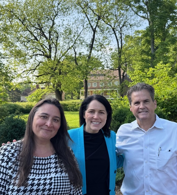
 Pictured from left to right: Jessica Dawkins, President/CEO of Historic Locust Grove, Louisville Metro Deputy Mayor Nicole George, Councilman Scott Reed
Greetings,
This morning, I had the pleasure of meeting with Jessica Dawkins, President/CEO of Historic Locust Grove, along with my good friend and former Council colleague, Deputy Mayor Nicole George.
Locust Grove is truly a hidden gem in our Metro Parks system!
We discussed ways the city can collaborate with Locust Grove in preparation for our nation's 250th celebration in 2026. The milestone is quickly approaching, and we want to ensure that the home of George Rogers Clark and the museum are in the best possible shape for the occasion.
A special thank you to Deputy Mayor George for stopping by! If you haven’t visited Locust Grove recently, I highly encourage you to do so. They host regular events, concerts, and have a breathtaking new pavilion available for gatherings and celebrations!
-Scott
Contract crews to perform concrete slab repairs
LOUISVILLE, Ky. (May 8, 2025) – The Kentucky Transportation Cabinet (KYTC) advises motorists of weekend lane and ramp closures on Interstate 71 and Interstate 265 (Gene Snyder Freeway) beginning Friday, May 9, in Jefferson County as part of the I-Move KY project. Details regarding traffic impacts are below.
Friday, May 9, at 8 p.m. through 6 a.m. on Monday, May 12:
- I-265 South will be reduced to one lane from mile marker 35 (near the I-265/I-71 interchange) to mile marker 30 (near KY 146 (La Grange Road)).
- I-265 North will be reduced to one lane from mile marker 28 (near KY 3084 (Old Henry Road)) to mile marker 35 (near the I-265/I-71 interchange).
- The I-265 South off-ramp to KY 146 (La Grange Road) at Exit 30 will be closed.
- The I-265 North on-ramp from KY 146 (La Grange Road) will be closed.
Friday, May 9, at 8 p.m. through midnight on Saturday, May 10:
- The I-71 North to I-265 North (Gene Snyder Freeway) ramp will be closed.
The lane and ramp closures are necessary for contract crews to perform concrete slab repairs. Drivers should heed signage, plan for increased travel times, and use caution when traveling through the work zone.
 Celebrate three decades of blooms, buds, and backyard magic at Gardeners’ Fair, your one-stop spring shop for everything green and growing.
Stroll through a vibrant marketplace of local vendors offering plants, tools, garden décor, and delightfully unexpected finds.
Watch live gardening demos, pick up expert tips, and get inspired to make your garden dreams grow.
Bring the whole crew—kid-friendly fun, live music, and plenty of space to roam make this a spring outing everyone will enjoy.
Don’t Miss: BUBBLES & BLOOMS
Toast to the season with floral-infused sips, garden bites by Chef Lawrence Weeks, and golden-hour vibes in full bloom. It’s your picture-perfect spring celebration.
Whether you’re a seasoned gardener, weekend plant warrior, or just here for the fresh air and fun—Gardeners’ Fair is about community, creativity, and cultivating joy.
Beat the lines—purchase your tickets online and show your confirmation at the gate.
 Join us on Saturday, May 10, at Locust Grove for an unforgettable afternoon as we celebrate 30 years of the Gardeners’ Fair with Bubbles & Blooms — a garden tea party that’s as fresh as spring itself.
Sip on sparkling drinks and herb-kissed mocktails, savor edible florals and seasonal bites by award-winning chef Lawrence Weeks, and stroll through blooming gardens..
Whether you’re here to sip, snack, shop, or soak in the sunshine, Bubbles & Blooms is your invitation to toast the season in style — right here, where Louisville begins and spring comes alive.
Admission:
$60 for Members $70 for Non-Members
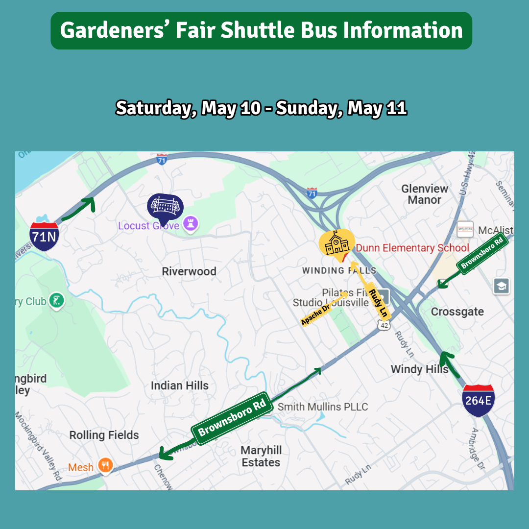 Thanks to our Sponsor, Pegasus Transportation, Locust Grove will offer a free shuttle from Dunn Elementary all weekend.
Getting to Dunn Elementary:
-
From Brownsboro: Turn directly onto Rudy Ln from Brownsboro Rd. Go past Panera and Fresh Market. Dunn Elementary will be on your left.
-
From Blankenbaker: Turn onto Blankenbaker Ln from Brownsboro Rd. Turn right onto Apache Rd. Keep straight on Apache Rd until you connect to Rudy Ln. Turn left onto Rudy Ln, and Dunn Elementary will be on your left.
*Due to continued construction, Blankenbaker is closed to River Road. Please keep that in mind when heading to Dunn Elementary.


Roadshow | Week of May 11, 2025
New items or changes in project status are shown in bold
Inclement weather or other unforeseen circumstances may arise, and as such, the information provided below is for advisory purposes only and subject to change without prior notice.
| I-Move KY |
|
| I-265 (Gene Snyder Freeway) |
Friday, May 9, at 8 p.m. through Monday, May 12 at 6 a.m.:
Friday, May 9, at 8 p.m. through midnight on Saturday, May 10:
- The I-71 North to I-265 North (Gene Snyder Freeway) ramp will be closed.
Monday, May 12, from 8 p.m. through Tuesday, May 13, at 6 a.m.:
- The I-265 North ramp to I-64 West will be closed.
Tuesday, May 13, from 8 p.m. through Wednesday, May 14, at 6 a.m.:
- The I-265 North ramp to I-64 West will be closed.
Tuesday, May 13, from 8 p.m. through Wednesday, May 14, at 6 a.m.:
- I-64 West will be reduced to one lane at mile point 18.5 (near the I-64/I-265 interchange).
Wednesday, May 14, from 8 p.m. through Thursday, May 15 at 6 a.m.:
- The I-265 North to I-64 West ramp will be closed.
- I-64 East will be reduced to two lanes at mile marker 17 (near KY 913/Blankenbaker Parkway).
|
| Jefferson County |
|
| I-64 East and West |
Traffic Impacts: Lane closures and traffic shifts are possible.
Date/Time: Daily and nightly.
Project Limits: I-64 East and West at mile point 11.799, near Exit 10 (Cannons Lane) on I-64 West, and near Exit 12 to I-264 (Watterson Expressway) on I-64 East.
Type of Work: Bridge replacement project.
Other Details: **Eastbound and westbound traffic is shifted to the outer shoulders. Construction is currently taking place in the median, and two 11-foot lanes will remain open in each direction for the duration of the project.
|
| I-65 South (John F. Kennedy Memorial Bridge) |
Date/Time: Once expansion joints have been fabricated as part of the expansion joint replacement project, additional details regarding the project's timing will be shared.
Project Limits: I-65 South (John F. Kennedy Memorial Bridge).
Other Details: The project is expected to be completed by April 2026, and intermittent lane closures are to be anticipated throughout the duration of construction.
|
| KY 841 North and South (Gene Snyder Freeway) |
Traffic Impacts: Single lane closures are possible.
Date/Time: Beginning Monday, May 5, through Saturday, May 10.
Daily – 9 a.m. to 3 p.m. | Nightly – 7 p.m. to 5 a.m.
Project Limits: KY 841 North and South (Gene Snyder Freeway), between mile points 35.0 and 37.7, near and through the East End Tunnel.
Type of Work: Routine maintenance of the roadway and East End Tunnel.
Other Details: Motorists should heed signage, use caution, and adjust commutes to accommodate the lane closures.
|
| KY 864 (Logan Street/Shelby Street) |
Traffic Impacts: Sidewalk and lane closures are possible.
Date/Time: Daily and nightly.
Project Limits: Between Goss Avenue and East Gray Street.
Type of Work: One-way to two-way conversion of the roadway.
Other Details: Work is underway ahead of asphalt resurfacing and the two-way conversion of the roadway.
*Work was temporarily paused on this project as KYTC engineers coordinated with contractors and utility providers to reduce utility conflicts along the corridor. Major work is expected to resume this Spring, with full completion expected by the Spring of 2026.
|
| KY 1819 (Billtown Road) |
Traffic Impacts: Lane closures and delays are possible.
Date/Time: Daily – 9 a.m. to 4 p.m.
Project Limits: Three sections of KY 1819 (Billtown Road):
- Easum Road through Mary Dell Lane
- Michael Edward Drive through Fairground Road
- Shady Acres Lane through Colonnades Place
Type of Work: Reconstruction of KY 1819 (Billtown Road) from north of Colonnades Place to south of Easum Road with new traffic signals, signal optimization, turn lanes, storage lanes, etc. (varying by intersection based on existing conditions and future traffic projections).
Other Details: The reconstruction project is expected to be completed by the Summer of 2025.
*Project webpage
|
| Clark Station Road |
Traffic Impacts: Road/bridge closure.
Project Limits: Clark Station Road Bridge over Long Run Creek.
Type of Work: Bridge replacement project.
Other Details: Construction will require the full closure of the existing bridge through August 1, 2025.
|
| South Pope Lick Road |
Traffic Impacts: Full closure of the bridge.
Date/Time: Beginning Wednesday, May 7, through Friday, June 6.
Project Limits: The South Pope Lick Road bridge over I-265 (Gene Snyder Freeway), between Poplar Lane and Tucker Station Road.
Type of Work: Bridge deck restoration and latex overlay.
Detour: Motorists are advised to follow the signed detour route: Pope Lick Road to Tucker Station Road, then to Plantside Drive and Rehl Road, before rejoining Pope Lick Road.
Other Details:
*During preliminary work, contract crews discovered additional deterioration on the bridge's deck that was visually obstructed prior to work beginning. The scope of the project has changed, thus requiring the full closure of the bridge for 30 days.
|
| *Various Locations |
Traffic Impacts: Lane closures and delays are possible as part of a mobile operation.
Date/Time: Overnight hours from 7 p.m. to 6 a.m.
Type of Work: Pavement marker (reflector) replacement and installation.
Other Details: Motorists should be observant of all road work signage and provide plenty of space for slow moving vehicles while traveling through the work zone.
|
| I-64 and I-264 *Various Exit Ramps |
Traffic Impacts: Ramp narrowing and shoulder closures.
Project Limits: Various interchange Exit ramps on I-64 and I-264.
Type of Work: Installation and upgrade of wrong-way pavement markings and signs.
Other Details: The Highway Safety Improvement Project will install and enhance wrong-way signs and pavement markings on interstate Exit ramps to discourage wrong-way driving. Motorists should reduce speeds and obey traffic control while workers are present. This project is expected to be completed by the Fall of 2025.
|
| |
|
| Bullitt County |
|
| I-65 North and South |
Traffic Impacts: Closure of the right lane.
Date/Time: Thursday, May 15, from 8 a.m. to noon.
Project Limits: I-65 North and South at mile point 112.4 and 105.9.
Type of Work: Core drilling and material testing to evaluate bridge deck overlays.
Other Details: Motorists should heed signage, use caution, and expect delays when traveling through the work zone.
|
| I-65/KY 480 (Cedar Grove Road) |
Traffic Impacts: Changing traffic patterns, lane shifts, and lane closures are possible as construction progresses.
Date/Time: Daily and nightly.
Project Limits: KY 480 (Cedar Grove Road) between I-65 between mile points 0.6 and 1.4.
Other Details: The interchange reconstruction project is expected to be completed by the Fall of 2025.
*The I-65 North off-ramp to KY 480 at Exit 116 will be closed from Friday, May 16, at 7 p.m. through Monday, May 19, at 6 a.m. Motorists will be prohibited from making a left turn onto KY 480 following the reopening of the ramp.
|
| KY 1116 (Zoneton Road) |
Traffic Impacts: Road closure.
Date/Time: Tuesday, May 13, from 9 a.m. to 3 p.m.
Project Limits: KY 1116 (Zoneton Road) at mile point 4.4 (at Wray Drive).
Type of Work: Cross drain replacement.
Other Details: Following the cross drain's replacement, crews will place a layer of dense-grade rock over it until asphalt can be laid. Drivers should exercise caution when driving over the newly replaced cross drain.
|
| *Various Locations |
Traffic Impacts: Lane closures and delays are possible as part of a mobile operation.
Date/Time: Overnight hours from 7 p.m. to 6 a.m.
Type of Work: Pavement marker (reflector) replacement and installation.
Other Details: Motorists should be observant of all road work signage and provide plenty of space for slow moving vehicles while traveling through the work zone.
|
| I-65 *Various Exit Ramps |
Traffic Impacts: Intermittent lane and ramp closures.
Date/Time: Nightly – 8 p.m. to 6 a.m. | Daily – 9 a.m. to 3 p.m.
Project Limits: Various interchange Exit ramps on I-65.
Type of Work: Upgrade and install wrong way pavement markings and signs.
Other Details: The Highway Safety Improvement Project will install and enhance wrong way signs and pavement markings on various interstate exit ramps to discourage wrong way driving. Motorists should reduce speeds and obey traffic control while workers are present. This project is set to be completed by the fall of 2025.
|
| |
|
| Franklin County |
|
| I-64/U.S. 127 Interchange |
Traffic Impacts: Lane closures and traffic shifts are possible.
Date/Time: Nightly.
Project Limits: The I-64/U.S. 127 interchange.
Type of Work: The realigning of the I-64 West off-ramp to U.S. 127 North and the I-64 West on-ramp from U.S. 127. Other improvements include the installation of a new signalized intersection on U.S. 127 to provide access to development entrances, which will be activated following project completion. Additionally, the intersection of Westridge Drive and Leonardwood Drive will be reconstructed to accommodate dual left turns onto Westridge Drive from U.S. 127.
Other Details: Traffic is now in its final configuration. The interchange reconstruction project is expected to be completed by the Summer of 2025.
|
| *Various Locations |
Traffic Impacts: Lane closures and delays are possible as a part of a mobile operation.
Date/Time: Overnight hours from 7 p.m. to 6 a.m.
Type of Work: Pavement marker (reflector) replacement and installation.
Other Details: Motorists should be observant of all road work signage and provide plenty of space for slow moving vehicles while traveling through the work zone.
|
| I-64 *Various Exit Ramps |
Traffic Impacts: Intermittent lane and ramp closures.
Date/Time: Nightly – 8 p.m. to 6 a.m. | Daily – 9 a.m. to 3 p.m.
Project Limits: Various interchange Exit ramps on I-64.
Type of Work: Upgrade and install wrong way pavement markings and signs.
Other Details: The Highway Safety Improvement Project will install and enhance wrong way signs and pavement markings on various interstate exit ramps to discourage wrong way driving. Motorists should reduce speeds and obey traffic control while workers are present. This project is set to be completed by the fall of 2025.
|
| |
|
| Oldham County |
|
| I-71 *Various Exit Ramps |
Traffic Impacts: Intermittent lane and ramp closures.
Date/Time: Nightly – 8 p.m. to 6 a.m. | Daily – 9 a.m. to 3 p.m.
Project Limits: Various interchange Exit ramps on I-71.
Type of Work: Upgrade and install wrong way pavement markings and signs.
Other Details: The Highway Safety Improvement Project will install and enhance wrong way signs and pavement markings on various interstate exit ramps to discourage wrong way driving. Motorists should reduce speeds and obey traffic control while workers are present. This project is set to be completed by the fall of 2025.
|
| |
|
| Spencer County |
|
| *Various Locations |
Traffic Impacts: Lane closures and delays possible as part of a mobile operation.
Date/Time: Daily – 7 a.m. to 9 p.m.
Type of Work: Pavement striping.
Other Details: Motorists should provide plenty of space to crews displaying "WET PAINT" signage and be observant of slowed vehicles while traveling through the work zone.
|
| |
|
| Shelby County |
|
| I-64 Widening and Improvement Project |
|
| KY 362 (Aiken Road) |
Traffic Impacts: Nightly road closures.
Date/Time: Nightly from 6 p.m. to midnight beginning Monday, May 12, through Thursday, May 15.
Project Limits: Ky 362 (Aiken Road) between mile points 3.6 and 3.7 (near Watch Hill Lane).
Type of Work: Cross drain replacement.
Other Details: Following the cross drain's replacement, crews will place a layer of dense-grade rock over it until asphalt can be laid. Drivers should exercise caution when driving over the newly replaced cross drain.
|
| *Various Locations |
Traffic Impacts: Lane closures and delays are possible as part of a mobile operation.
Date/Time: Overnight hours from 7 p.m. to 6 a.m.
Type of Work: Pavement marker (reflector) replacement and installation.
Other Details: Motorists should be observant of all road work signage and provide plenty of space for slow moving vehicles while traveling through the work zone.
|
| I-64 *Various Exit Ramps |
Traffic Impacts: Intermittent lane and ramp closures.
Date/Time: Nightly – 8 p.m. to 6 a.m. | Daily – 9 a.m. to 3 p.m.
Project Limits: Various interchange Exit ramps on I-64.
Type of Work: Upgrade and install wrong way pavement markings and signs.
Other Details: The Highway Safety Improvement Project will install and enhance wrong way signs and pavement markings on various interstate exit ramps to discourage wrong way driving. Motorists should reduce speeds and obey traffic control while workers are present. This project is set to be completed by the fall of 2025.
|
| |
|
| Henry County |
|
| *Various Locations |
Traffic Impacts: Lane closures and delays possible as a part of a mobile operation.
Date/Time: Daily – 7 a.m. to 9 p.m.
Type of Work: Pavement striping.
Other Details: Motorists should provide plenty of space to crews displaying "WET PAINT" signage and be observant of slowed vehicles while traveling through the work zone.
|
| I-71 *Various Exit Ramps |
Traffic Impacts: Intermittent lane and ramp closures.
Date/Time: Nightly – 8 p.m. to 6 a.m. | Daily – 9 a.m. to 3 p.m.
Project Limits: Various interchange Exit ramps on I-71.
Type of Work: Upgrade and install wrong way pavement markings and signs.
Other Details: The Highway Safety Improvement Project will install and enhance wrong way signs and pavement markings on various interstate exit ramps to discourage wrong way driving. Motorists should reduce speeds and obey traffic control while workers are present. This project is set to be completed by the fall of 2025.
|
| |
|
| Trimble County |
*Routine maintenance |
| 2025 Resurfacing Projects |
*Resurfacing projects will begin on or after April 1, 2025, and will be completed by the Fall of 2025. Motorists should heed signage and use caution when traveling through the work zone.* |
| |
|
| Jefferson County |
|
| KY 2830 (Arthur Street) |
Project Limits:
KY 2830 (Arthur Street) east of Brandies Avenue/KY 61 extending north to University Boulevard.
|
| U.S. 31E (Bardstown Road) |
Project Limits:
U.S. 31E (Bardstown Road) at the Bullitt/Jefferson County line, extending south of Colonel Hancock Drive.
|
|
KY 1631 (Crittenden Drive)
*Completed*
|
Project Limits:
KY 1631 (Crittenden Drive) at the beginning of state maintenance near the I-264 interchange, extending north to U.S. 60A (Eastern Parkway).
|
| KY 1531 (Johnson Road) |
Project Limits:
KY 1531 (Johnson Road) from the railroad crossing extending north to Aiken Road.
|
|
KY 61 (Arthur Street)
*Completed*
|
Project Limits:
KY 61 (Arthur Street) beginning east of Brandies Avenue extending north to I-65 ramp/East Gaulbert Avenue.
|
| KY 155 (Taylorsville Road) |
Project Limits:
KY 155 (Taylorsville Road) beginning at KY 1747 (Hurstbourne Lane) extending north to KY 1932 (Breckenridge Lane).
|
| KY 329 (Covered Bridge Road) |
Project Limits:
KY 329 (Covered Bridge Road) beginning at U.S. 42 extending east to the Jefferson/Oldham County line.
*Completed*
|
| |
|
| Bullitt County |
|
| KY 1531 (Dawson Hill Road) |
Project Limits:
KY 1531 (Dawson Hill Road) from KY 1319 extending north to the Bullitt/Jefferson County line.
|
| KY 2672 (Knob Creek Road) |
Project Limits:
KY 2672 (Knob Creek Road) from KY 1526 (Brooks Hill Road) extending north towards Lake Elmo Road.
|
| KY 2674 (Stringer Lane) |
Project Limits:
KY 2674 (Stringer Lane) from U.S. 31E extending north to KY 44.
|
| |
|
| Franklin County |
|
| KY 12 (Dry Ridge Road/Flat Creek Road) |
Project Limits:
KY 12 (Dry Ridge Road/Flat Creek Road) from the Shelby/Franklin County line extending east to Harvieland Road.
|
| KY 1570 (St Johns Road) |
Project Limits:
KY 1570 (St Johns Road) from the bridge at mile point 4.2, extending north to KY 12.
|
| U.S. 127 (Wilkinson Boulevard) |
Project Limits:
U.S. 127 (Wilkinson Boulevard) near Hall Street extending north to the south end of the U.S. 127/KY 2261 bridge.
|
| |
|
| Oldham County |
|
| KY 362 (Central Avenue) |
Project Limits:
KY 362 (Central Avenue) from Rosswoods Drive extending south towards KY 146.
|
| KY 329 (Covered Bridge Road) |
Project Limits:
KY 329 (Covered Bridge Road) from KY 329B extending east to mile point 8.754.
*Completed*
|
| KY 1694 (Gum Street) |
Project Limits:
KY 1694 (Gum Street) from KY 329 extending north towards Mason Lane.
|
| U.S. 42 |
Project Limits:
U.S. 42 east of KY 1694 (Gum Street) extending east to the Oldham/Henry County line.
|
| |
|
| Shelby County |
|
| KY 362 (Aiken Road) |
Project Limits:
KY 362 (Aiken Road) from the Oldham/Shelby County line extending east near Webb Road.
|
| U.S. 60 (Frankfort Road) |
Project Limits:
U.S. 60 (Frankfort Road) beginning at KY 395 extending east to the Shelby/Franklin County line.
|
| KY 1408 (Loydsburg Road) |
Project Limits:
KY 1408 (Loydsburg Road) from KY 362 extending west to the Shelby/Oldham County line.
|
| KY 322 (Lucas Road) |
Project Limits:
KY 322 (Lucas Road) from KY 53 extending north to the Shelby/Henry County line.
|
| KY 53 (Mt. Eden Road) |
Project Limits:
KY 53 (Mt. Eden Road) beginning at KY 714/KY 44 extending north to KY 1790 (Hooper Station Road).
|
| |
|
| Spencer County |
|
| KY 1633 (Elk Creek Road) |
Project Limits:
KY 1633 (Elk Creek Road) from KY 1135 (Industrial Road) extending north to KY 55.
|
|
KY 1795 (Mill Road)
*Completed*
|
Project Limits:
KY 1795 (Mill Road) from Paradise Pointe Road extending east to KY 636.
|
| KY 55 (Shelbyville Road) |
Project Limits:
KY 55 (Shelbyville Road) beginning at KY 155 extending north to the Spencer/Shelby County line.
|
| |
|
| Henry County |
|
| U.S. 421 (Campbellsburg Road) |
Project Limits:
U.S. 421 (Campbellsburg Road) at the I-71 overpass extending to the Henry/Trimble County line.
|
| KY 1360 (Franklinton Road) |
Project Limits:
KY 1360 (Franklinton Road) from KY 22 extending north to Bullitt Hill Road.
|
| KY 241 (Pleasureville Road) |
Project Limits:
KY 241 (Pleasureville Road) beginning at the Shelby/Henry County line extending north to U.S. 421.
|
| |
|
| Trimble County |
|
| KY 1256 (Fisher Ridge Road) |
Project Limits:
KY 1256 (Fisher Ridge Road) from Detmer Lane extending east to KY 625.
|
| KY 3175 (Sulphur-Bedford Road) |
Project Limits:
KY 3175 (Sulphur-Bedford Road) from Hoskins Lane extending north to U.S. 42.
|
We now have a new way for you to map crime around you. Just click here and view our new interactive crime mapping tool for Division 5 & 8 or for each beat in Division 5 & 8. And save it in your favorites to view crime anytime it's updated daily. On the page is a Quickfind tool that allows you to put your address in and subscribe to crime trends, alerts and block watch reports for your police beat. Forward this email to your friends and family!
For further information on Councilman Scott Reed or District 16 please visit www.louisvilleky.gov/government/metro-council-district-16
You can also reach out directly by phone at 502.574.1116 or by email at scott.reed@louisvilleky.gov.
601 West Jefferson Street
Louisville, KY 40202
Having Trouble Viewing this eNewsletter? Click here to view it on the web.
|