 |
|
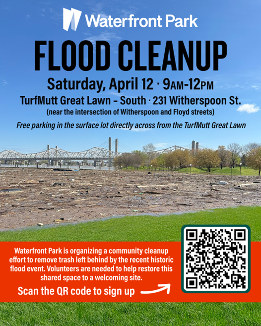
Waterfront Park Flood Cleanup
Saturday April 12, 9am-12pm
Waterfront Park is organizing a community cleanup effort to remove trash left behind by the recent historic flood event. Volunteers are needed to help restore this shared space to a welcoming site.
Meeting Location:
TurfMutt Great Lawn South
231 Witherspoon Street, Louisville, KY 40202.
(near the intersection of Witherspoon and Floyd streets)
Free parking in the surface lot directly across from the TurfMutt Great Lawn.
Volunteers should access the park from Main Street as surrounding roadways remain closed due to flooding.
Waterfront Park staff will be on hand to assist with the cleanup, providing supplies such as trash bags, gloves, and pinchers. Volunteers are encouraged to wear long pants, sturdy closed-toe shoes or rubber boots, waterproof gloves (if available) and bring a water bottle to stay hydrated. This is an opportunity to give back, meet other community members, and take pride in keeping Waterfront Park a beautiful, safe space for all.
Volunteers will be asked to check in and sign a waiver to receive supplies for the cleanup.
Anyone who would like to volunteer should register via the link below.
Click Here For The Volunteer Signup Form
|
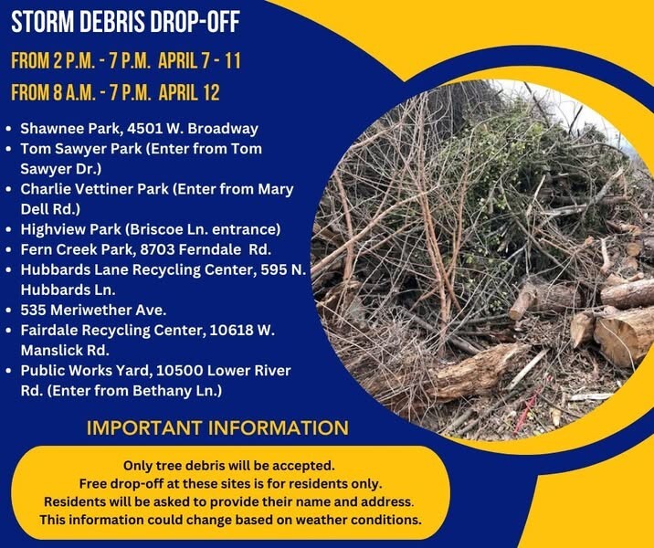 Storm debris drop-off sites are scheduled to open Monday.
The information and locations are subject to change, depending on weather circumstances.
DATES/TIMES:
April 7 - April 11 from 2 p.m. - 7 p.m.
April 12 from 8 a.m. to 7 p.m.
LOCATIONS:
-- Shawnee Park, 4501 W. Broadway
-- Tom Sawyer Park (Enter from Tom Sawyer Dr.)
-- Charlie Vettiner Park (Enter from Mary Dell Rd.)
-- Highview Park (Briscoe Ln. entrance)
-- Fern Creek Park, 8703 Ferndale Rd.
-- Hubbards Lane Recycling Center, 595 N. Hubbards Ln.
-- 535 Meriwether Ave.
-- Fairdale Recycling Center, 10618 W. Manslick Rd.
-- Public Works Yard, 10500 Lower River Rd. (Enter from Bethany Ln.)
IMPORTANT INFORMATION:
-- Only tree debris will be accepted.
-- Free drop-off at these sites is for residents only.
-- Residents will be asked to provide their name and address.
 At Louisville Water, our hearts go out to the residents and businesses that face flooding along River Road, and we hope the expected high water will have minimal impact. We have paused Residual Line Project construction on River Road. Be advised that flooding could prevent access to roads in this area. Once work resumes and roads reopen, follow the detours that were in place last week.
- If you are trying to access Thurman-Hutchins Park, Cox Park, Different Strokes, Louisville Islamic Center, or Louisville Boat Club, please access River Road from Indian Hills Trail.
- If you are trying to access River Road west of Louisville Turners, please use River Road at Zorn Avenue or Mockingbird Valley Road. To access Louisville Turners, Waldoah Beach Road, and Wagners Beach Road from River Road, use Zorn Avenue or Mockingbird Valley Road.
- If you are trying to access the Riviera Neighborhood (Riverside Drive, W Riverside Drive, E Riverside Drive, Riviera Drive), please use Blankenbaker Lane.
Residual Line Project - Louisville Water Company
The Office of Planning is preparing for the 2025 Zoning Matters conversation series at the libraries, with 12 total events scheduled throughout the year. This is a great opportunity for residents and community members to connect with city planners, ask questions about zoning and development policies, and learn more about the ongoing Land Development Code (LDC) Reform process. More information is on our website here: www.louisvilleky.gov/ldcreform. There are a few upcoming dates near District 16 this spring:
-
Northeast Regional Library on Tuesday, April 15th from 3 – 7 PM


Safety:
We urge everyone to stay away from downed wires and to keep others and pets away too. People should always assume a downed wire is an energized line. We urge customers to report any downed wires immediately. If the situation is an emergency, they should call 911. In non-emergency situations they may call LG&E at 502-589-1444 (fast path 1-1-3). Customers should also remain cautious when clearing fallen tree limbs and debris from their yard and avoid contacting any branches or debris that may be in direct contact with a power line.
Restoration process:
During and after storms, LG&E’s service restoration takes place through a prioritization process that involves several different layers. While we work to restore all customers’ service in the field, we will also use our ability to reroute power, where we can, from our control center, coupled with automated controls installed on our system, to limit the number of customers affected. Procedure as follows:
- First, we respond to emergency situations, reports of downed wires and unsafe conditions.
- Next, we will begin restoration of critical services in our community - hospitals, fire and police stations, airports, and nursing homes.
- Then, we restore outage events with the highest number of customers, which will bring back service as safely and quickly as possible.
- Next, we repair any damaged equipment. Whenever possible, temporary repairs are made to restore power quickly and allow time for longer repairs to take place.
- For customers still without power, crews then make repairs to the individual power lines and service lines that feed directly to customers’ individual homes and businesses.
- LG&E will continue to update estimated restoration times based on crews’ feedback in the field and the level of damage our crews are finding at customers’ properties. Customers are encouraged to continue checking their status by visiting https://stormcenter.lge-ku.com/ or by utilizing our mobile APP.
Our crews and partners will be in the field safely working around the clock on all aspects of the restoration effort. They are protecting the public, assessing, and repairing damage and restoring power to the communities we are proud to serve.
In the beginning of a large-scale power outage, sometimes up to 24 hours or more depending on the severity of the storm, it may appear LG&E is not doing anything, but in actuality, our crews are out assessing damage to our system. We must first assess the totality of the outage before we begin to repair. Assessment may involve inspecting substations/equipment and include our employees walking/driving the transmission/distribution lines where an outage has occurred and physically finding the problem, trees/equipment, etc. As you can imagine, we have over 3,400 miles of overhead lines in Jefferson County, so this takes a good amount of time.
|
BBB serving Greater Kentucky and South Central Indiana warns of storm-chasing scammers in the aftermath of the severe storms and tornadoes that struck the area.
|
With any destructive and severe weather, there is an increased potential of out-of-town storm chasers looking to take advantage of victims as they begin the process of cleaning up and repairing property damage. BBB warns residents affected by the storms to beware of these scammers.
BBB offers the following tips for storm victims:
- Know your rights and responsibilities as provided by the state Attorney General. Kentucky residents can contact the Kentucky Attorney General’s office at ag.ky.gov or call 502.696.5300.
- Businesses must be licensed. Contact the Revenue Commission at 502.574.4860 to check out a company’s licensure.
- Many municipalities require a solicitation permit if salespeople go door-to-door. Verify that they need to have a permit by contacting your local Township or Municipality or call Permits & Licensing at 502.574.3321
- While most roofing contractors abide by the law, be careful allowing someone you do not know to inspect your roof. An unethical contractor may actually create damage to get work.
- Try to get at least 3-4 quotes from contractors, and insist that payments be made to the company, not an individual.
- Do not pay for the job in advance. Be wary of any contractor who demands full or half payment upfront.
- Resist high-pressure sales tactics, such as the “good deal” you’ll get only if you hire the contractor on the spot.
- Get a written contract that specifies the price, the work to be done, the amount of liability insurance coverage maintained by the contractor, and a time frame. Require a copy of their current certificate of insurance.
- For general questions or complaints related to insurance, contact your state’s Department of Insurance. Kentucky residents can visit insurance.ky.gov or call 502.564.3630.
- Pay by credit card, if possible; you may have additional protection if there’s a problem.
- If you suspect a company may be price gouging necessary goods or services due to the area storm damage, report the business to BBB and the Attorney General’s office.
- Beware of FEMA imposters. In the past, scammers have impersonated FEMA to try to scam consumers. Remember that FEMA does not charge for inspections, and they always wear ID badges. If you are still unsure, check with FEMA first at fema.gov or call 202.646.2500.
Finally, BBB advises consumers to be wary of any scam callers masquerading as gas and electric company employees. LG&E and KU will never call consumers and demand payment immediately over the phone in order to restore power (or prevent it from being shut off). For any concerns regarding utilities, contact your provider directly. Do not give your financial information over the phone to any unsolicited caller.

LOUISVILLE, Ky. (April 9, 2025) – The Kentucky Transportation Cabinet (KYTC) advises motorists of ramp closures on Interstate 64 and Interstate 265 (Gene Snyder Freeway) beginning Friday, April 11, in Jefferson County.
The I-64 West ramp to I-265 South (Gene Snyder Freeway) will be closed from 8 p.m. on Friday, April 11, through 6 a.m. on Monday, April 14. I-265 South will also be reduced to one lane at mile point 25.4 (at the bridge over I-64) beginning at 8 p.m. on Friday, April 11, through 6 a.m. on Monday, April 14.
The I-265 South to I-64 East ramp will also be closed beginning at midnight on Friday, April 11, through 6 a.m. on Saturday, April 12. Additionally, the I-265 North off-ramp to KY 22 (Brownsboro Road) will be closed from 7:30 a.m. on Saturday, April 12, through 4 p.m. on Saturday, April 12.
Motorists should heed signage, seek alternate routes, and use caution when traveling through the work zone.
Construction activities scheduled for the next month include:
- Work continues on the water tank next to the water tower
- Work is scheduled to begin on paving roads on the south end of the construction site soon.
- Work continues on the guard shack near the entrance of the construction site.
- Drywall, insulation and paint are being installed in the West Bar of the medical facility.
- Interior framing and utility rough in is taking place in the East and West Bars of the medical facility.
- Work on the loading dock and laundry facility on the west side of the medical facility continues.
- Utilities and equipment installation at the Central Utility Plant continues, as well as exterior masonry.
- Exterior metal wall framing continues on the West Bar of the medical facility.
- Utility and elevator installation continue in the North Parking Structure.
- The installation of photovoltaic (solar) panels continues at the North Parking Structure.
- Work continues on both the Eastern Electrical Building near the USACE trailer and the Western Electrical Building just north of the North Parking Structure.
New items or changes in project status are shown in bold
Inclement weather or other unforeseen circumstances may arise, and as such, the information provided below is for advisory purposes only and subject to change without prior notice.
For District 5's high water report, click HERE.
| I-Move KY |
|
| I-265 (Gene Snyder Freeway) |
- Beginning Monday, March 31, at 9 a.m. through approximately Wednesday, April 30.
-
I-265 South (Gene Snyder Freeway) will be reduced to one lane at mile point 25.4 (at the bridge over I-64) beginning at 8 p.m. on Friday, April 11, through 6 a.m. on Monday, April 14. The lane closures are necessary as contract crews work to apply a latex overlay to the bridge as part of the I-Move Kentucky project. This treatment will extend the structure's lifespan and improve roadway drivability.
-
The I-64 West ramp to I-265 South will be closed from 8 p.m. on Friday, April 11, through 6 a.m. on Monday, April 14 as part of the above latex overlay work.
-
The ramp from I-265 South to I-64 East will be closed from Friday, April 11, at midnight, through Saturday, April 12, at 6 a.m.
- The I-265 North ramp to Brownsboro Road will be closed from Saturday, April 12, at 7:30 a.m. through Saturday, April 12, at 4 p.m. for routine maintenance.
|
| Jefferson County |
|
| I-64 East and West |
Traffic Impacts: Shoulder closures are possible.
Date/Time: Daily and nightly.
*Major work will begin in mid-May.
Project Limits: I-64 East and West at mile point 11.799, near Exit 10 (Cannons Lane) on I-64 West, and near Exit 12 to I-264 (Watterson Expressway) on I-64 East.
Type of Work: Bridge replacement project.
Other Details: As a necessary safety precaution, the right lane of I-64 East is currently closed at the bridge over the Middle Fork of Beargrass Creek at mile point 11.799 (near Exit 12 to I-264/Watterson Expressway) due to bridge deck damage. Contract crews will perform temporary repairs ahead of a larger bridge replacement project that began in early March.
|
| I-64 East |
Traffic Impacts: Closure of the right lane.
Date/Time: Daily from 9 a.m. to 3 p.m. and nightly from 6 p.m. to 10 p.m. beginning Monday, March 31, through Friday, April 11.
Project Limits: I-64 East from mile marker 8 (near U.S. 60A/Lexington Road) to mile marker 10 (near KY 2048/Cannons Lane).
Type of Work: Routine maintenance of the highway.
Other Details: Motorists should heed signage and use caution when traveling through the work zone.
|
| I-65 South (John F. Kennedy Memorial Bridge) |
Traffic Impacts: The left three lanes are now open. The left two lanes are expected to close for a brief period the week of Monday, April 14, for the removal of equipment.
Date/Time: Once the expansion joints have been fabricated, more details regarding the project's timing will be shared.
Project Limits: I-65 South (John F. Kennedy Memorial Bridge).
Other Details: The project is expected to be completed by April 2026, and intermittent lane closures are to be anticipated throughout the duration of construction.
|
| KY 841 North and South (Gene Snyder Freeway) |
Traffic Impacts: Single lane closures are possible.
Date/Time: Beginning Monday, April 14, through Saturday, April 19.
Daily – 9 a.m. to 3 p.m. | Nightly – 7 p.m. to 5 a.m.
Project Limits: KY 841 North and South (Gene Snyder Freeway), between mile points 35.0 and 37.7, near and through the East End Tunnel.
Type of Work: Routine maintenance of the roadway and East End Tunnel.
Other Details: Motorists should heed signage, use caution, and adjust commutes to accommodate the lane closures.
|
| KY 864 (Logan Street/Shelby Street) |
Traffic Impacts: Sidewalk and lane closures are possible.
Date/Time: Daily and nightly.
Project Limits: Between Goss Avenue and East Gray Street.
Type of Work: One-way to two-way conversion of the roadway.
Other Details: Work is underway ahead of asphalt resurfacing and the two-way conversion of the roadway.
*Work was temporarily paused on this project as KYTC engineers coordinated with contractors to reduce utility conflicts along the corridor. Major work is expected to resume this Spring, with full completion expected by the Spring of 2026.
|
| KY 1531 (Johnson Road) |
Traffic Impacts: Single lane closures with flagging measures are possible.
Date/Time: Daily from 9 a.m. to 3 p.m. beginning Monday, March 31.
Project Limits: KY 1531 (Johnson Road) from the railroad crossing on KY 1531, extending north to Aiken Road (from mile point 9.799 to mile point 11.789).
Type of Work: Base failure repairs ahead of asphalt resurfacing project.
|
| KY 1819 (Billtown Road) |
Traffic Impacts: Lane closures and delays are possible.
Date/Time: Daily – 9 a.m. to 4 p.m.
Project Limits: Three sections of KY 1819 (Billtown Road):
- Easum Road through Mary Dell Lane
- Michael Edward Drive through Fairground Road
- Shady Acres Lane through Colonnades Place
Type of Work: Reconstruction of KY 1819 (Billtown Road) from north of Colonnades Place to south of Easum Road with new traffic signals, signal optimization, turn lanes, storage lanes, etc. (varying by intersection based on existing conditions and future traffic projections).
Other Details: The reconstruction project is expected to be completed by the Summer of 2025.
*Project webpage
|
| KY 3084 (Old Henry Road) |
Traffic Impacts: Traffic will be reduced to one lane and shifted into the median.
Project Limits: KY 3084 (Old Henry Road) from Woodmont Park Lane to Old Henry Trail.
Type of Work: Corrective work.
Other Details: Traffic impacts are expected to remain in place through the completion of work. Motorists should heed signage and use caution when traveling through the work zone.
|
| *Various Locations |
Traffic Impacts: Lane closures and delays are possible as a part of a mobile operation.
Date/Time: Overnight hours from 7 p.m. to 6 a.m.
Type of Work: Pavement marker (reflector) replacement and installation.
Other Details: Motorists should be observant of all road work signage and provide plenty of space for slow moving vehicles while traveling through the work zone.
|
| |
|
| Bullitt County |
|
| I-65/KY 480 (Cedar Grove Road) |
Traffic Impacts: Changing traffic patterns, lane shifts, and lane closures are possible as construction progresses.
Date/Time: Daily and nightly.
Project Limits: KY 480 (Cedar Grove Road) between I-65 between mile points 0.6 and 1.4.
Other Details: The interchange reconstruction project is expected to be completed by the Fall of 2025.
* The I-65 North on-ramp to KY 480 (Cedar Grove Road) will close at 7 p.m. on Friday, April 11, and remain closed through 5 a.m. on Monday, April 14. The weekend ramp closure is necessary for contract crews to complete asphalt work as part of the I-65/KY 480 interchange reconstruction project.
Drivers should follow the signed detour by taking KY 480 (Cedar Grove Road) westbound to KY 61 northbound, then continuing on KY 44 eastbound to reach the I-65 interchange.
|
| *Various Locations |
Traffic Impacts: Lane closures and delays are possible as a part of a mobile operation.
Date/Time: Overnight hours from 7 p.m. to 6 a.m.
Type of Work: Pavement marker (reflector) replacement and installation.
Other Details: Motorists should be observant of all road work signage and provide plenty of space for slow moving vehicles while traveling through the work zone.
|
| |
|
| Franklin County |
|
| I-64/U.S. 127 Interchange |
Traffic Impacts: Lane closures and traffic shifts are possible.
Date/Time: Nightly.
Project Limits: The I-64/U.S. 127 interchange.
Type of Work: The realigning of the I-64 West off-ramp to U.S. 127 North and the I-64 West on-ramp from U.S. 127. Other improvements include the installation of a new signalized intersection on U.S. 127 to provide access to development entrances, which will be activated following project completion. Additionally, the intersection of Westridge Drive and Leonardwood Drive will be reconstructed to accommodate dual left turns onto Westridge Drive from U.S. 127.
Other Details: Traffic is now in its final configuration. The interchange reconstruction project is expected to be completed by the Summer of 2025.
*Press release
|
| U.S. 421 (Bald Knob Road) |
Traffic Impacts: Nightly road closures.
Date/Time: Nightly from 6 p.m. to midnight beginning Monday, March 24, through Monday, April 7.
Project Limits: U.S. 421 (Bald Knob Road) to KY 1570 (St Johns Road).
Type of Work: Base failure repairs and cross drain replacements ahead of an upcoming resurfacing project.
Other Details: Motorists should follow posted detours around the affected area while work is underway.
|
| KY 1685 (Bedford Road) |
Traffic Impacts: Road closure.
Date/Time: Beginning Tuesday, March 4, through Monday, April 14.
Project Limits: KY 1685 (Bedford Road) at the intersection of U.S. 460 (Georgetown Road) at mile point 1.5, and KY 1685 (Bedford Road) at the intersection of U.S. 421 (W Leestown Pike) at mile point 11.4.
Type of Work: KYTC crews will clear debris and repair the roadway following recent weather events.
Other Details: Local thru traffic only.
|
| *Various Locations |
Traffic Impacts: Lane closures and delays are possible as a part of a mobile operation.
Date/Time: Overnight hours from 7 p.m. to 6 a.m.
Type of Work: Pavement marker (reflector) replacement and installation.
Other Details: Motorists should be observant of all road work signage and provide plenty of space for slow moving vehicles while traveling through the work zone.
|
| |
|
| Oldham County |
|
| *Various Exit ramps |
Project Limits: Various interchange Exit ramps on I-71.
Type of Work: Installation and upgrade of wrong-way pavement markings and signs.
Other Details: The Highway Safety Improvement Project will install and enhance wrong-way signs and pavement markings on interstate Exit ramps to discourage wrong-way driving. Motorists should reduce speeds and obey traffic control while workers are present. This project is expected to be completed by the Fall of 2025.
|
| |
|
| Spencer County |
|
| KY 1392 (Grays Run Road) |
Traffic Impacts: Daily and nightly road closures.
Date/Time: Daily from 9 a.m. to 2 p.m. | Nightly from 6 p.m. to 12 a.m. beginning Tuesday, April 8, through Wednesday, April 30.
Project Limits: KY 1392 (Grays Run Road) from mile point 2.0 to mile point 4.5. *Crews will work in sections.*
Type of Work: Cross drain replacements ahead of an upcoming resurfacing project.
Other Details: Following the replacement of the cross drains, crews will place a layer of dense-grade rock over it until asphalt can be laid. Drivers should exercise caution when driving over the newly replaced cross drains.
|
| *Various Locations |
Traffic Impacts: Lane closures and delays possible as a part of a mobile operation.
Date/Time: Daily – 7 a.m. to 9 p.m.
Type of Work: Pavement striping.
Other Details: Motorists should provide plenty of space to crews displaying "WET PAINT" signage and be observant of slowed vehicles while traveling through the work zone.
|
| |
|
| Shelby County |
|
| I-64 Widening and Improvement Project |
|
| KY 53 (Mt. Eden Road) |
Traffic Impacts: Road closure.
Date/Time: Beginning Monday, April 14, at 7:30 a.m. through Friday, May 2.
Project Limits: KY 53 (Mt. Eden Road) from mile point 1.62 at Lisby Lane to mile point 2.4.
Type of Work: Routine maintenance of the roadway including base failure repairs, slope protection measures, and cross drain replacements.
|
| *Various Locations |
Traffic Impacts: Lane closures and delays are possible as a part of a mobile operation.
Date/Time: Overnight hours from 7 p.m. to 6 a.m.
Type of Work: Pavement marker (reflector) replacement and installation.
Other Details: Motorists should be observant of all road work signage and provide plenty of space for slow moving vehicles while traveling through the work zone.
|
| |
|
| Henry County |
|
| *Various Exit ramps |
Project Limits: Various interchange Exit ramps on I-71.
Type of Work: Installation and upgrade of wrong-way pavement markings and signs.
Other Details: The Highway Safety Improvement Project will install and enhance wrong-way signs and pavement markings on interstate Exit ramps to discourage wrong-way driving. Motorists should reduce speeds and obey traffic control while workers are present. This project is expected to be completed by the Fall of 2025.
|
| |
|
| Trimble County |
*Routine maintenance |
| 2025 Resurfacing Projects |
*Resurfacing projects will begin on or after April 1, 2025, and will be completed by the Fall of 2025. Motorists should heed signage and use caution when traveling through the work zone.* |
| |
|
| Jefferson County |
|
| KY 2830 (Arthur Street) |
Project Limits:
KY 2830 (Arthur Street) east of Brandies Avenue/KY 61 extending north to University Boulevard.
|
| U.S. 31E (Bardstown Road) |
Project Limits:
U.S. 31E (Bardstown Road) at the Bullitt/Jefferson County line, extending south of Colonel Hancock Drive.
|
|
KY 1631 (Crittenden Drive)
*Completed*
|
Project Limits:
KY 1631 (Crittenden Drive) at the beginning of state maintenance near the I-264 interchange, extending north to U.S. 60A (Eastern Parkway).
|
| KY 1531 (Johnson Road) |
Project Limits:
KY 1531 (Johnson Road) from the railroad crossing extending north to Aiken Road.
|
|
KY 61 (Arthur Street)
*Completed*
|
Project Limits:
KY 61 (Arthur Street) beginning east of Brandies Avenue extending north to I-65 ramp/East Gaulbert Avenue.
|
| KY 155 (Taylorsville Road) |
Project Limits:
KY 155 (Taylorsville Road) beginning at KY 1747 (Hurstbourne Lane) extending north to KY 1932 (Breckenridge Lane).
|
| KY 329 (Covered Bridge Road) |
Project Limits:
KY 329 (Covered Bridge Road) beginning at U.S. 42 extending east to the Jefferson/Oldham County line.
|
| |
|
| Bullitt County |
|
| KY 1531 (Dawson Hill Road) |
Project Limits:
KY 1531 (Dawson Hill Road) from KY 1319 extending north to the Bullitt/Jefferson County line.
|
| KY 2672 (Knob Creek Road) |
Project Limits:
KY 2672 (Knob Creek Road) from KY 1526 (Brooks Hill Road) extending north towards Lake Elmo Road.
|
| KY 2674 (Stringer Lane) |
Project Limits:
KY 2674 (Stringer Lane) from U.S. 31E extending north to KY 44.
|
| |
|
| Franklin County |
|
| KY 12 (Dry Ridge Road/Flat Creek Road) |
Project Limits:
KY 12 (Dry Ridge Road/Flat Creek Road) from the Shelby/Franklin County line extending east to Harvieland Road.
|
| KY 1570 (St Johns Road) |
Project Limits:
KY 1570 (St Johns Road) from the bridge at mile point 4.2, extending north to KY 12.
|
| U.S. 127 (Wilkinson Boulevard) |
Project Limits:
U.S. 127 (Wilkinson Boulevard) near Hall Street extending north to the south end of the U.S. 127/KY 2261 bridge.
|
| |
|
| Oldham County |
|
| KY 362 (Central Avenue) |
Project Limits:
KY 362 (Central Avenue) from Rosswoods Drive extending south towards KY 146.
|
| KY 329 (Covered Bridge Road) |
Project Limits:
KY 329 (Covered Bridge Road) from KY 329B extending east to mile point 8.754.
|
| KY 1694 (Gum Street) |
Project Limits:
KY 1694 (Gum Street) from KY 329 extending north towards Mason Lane.
|
| U.S. 42 |
Project Limits:
U.S. 42 east of KY 1694 (Gum Street) extending east to the Oldham/Henry County line.
|
| |
|
| Shelby County |
|
| KY 362 (Aiken Road) |
Project Limits:
KY 362 (Aiken Road) from the Oldham/Shelby County line extending east near Webb Road.
|
| U.S. 60 (Frankfort Road) |
Project Limits:
U.S. 60 (Frankfort Road) beginning at KY 395 extending east to the Shelby/Franklin County line.
|
| KY 1408 (Loydsburg Road) |
Project Limits:
KY 1408 (Loydsburg Road) from KY 362 extending west to the Shelby/Oldham County line.
|
| KY 322 (Lucas Road) |
Project Limits:
KY 322 (Lucas Road) from KY 53 extending north to the Shelby/Henry County line.
|
| KY 53 (Mt. Eden Road) |
Project Limits:
KY 53 (Mt. Eden Road) beginning at KY 714/KY 44 extending north to KY 1790 (Hooper Station Road).
|
| |
|
| Spencer County |
|
| KY 1633 (Elk Creek Road) |
Project Limits:
KY 1633 (Elk Creek Road) from KY 1135 (Industrial Road) extending north to KY 55.
|
|
KY 1795 (Mill Road)
*Completed*
|
Project Limits:
KY 1795 (Mill Road) from Paradise Pointe Road extending east to KY 636.
|
| KY 55 (Shelbyville Road) |
Project Limits:
KY 55 (Shelbyville Road) beginning at KY 155 extending north to the Spencer/Shelby County line.
|
| |
|
| Henry County |
|
| U.S. 421 (Campbellsburg Road) |
Project Limits:
U.S. 421 (Campbellsburg Road) at the I-71 overpass extending to the Henry/Trimble County line.
|
| KY 1360 (Franklinton Road) |
Project Limits:
KY 1360 (Franklinton Road) from KY 22 extending north to Bullitt Hill Road.
|
| KY 241 (Pleasureville Road) |
Project Limits:
KY 241 (Pleasureville Road) beginning at the Shelby/Henry County line extending north to U.S. 421.
|
| |
|
| Trimble County |
|
| KY 1256 (Fisher Ridge Road) |
Project Limits:
KY 1256 (Fisher Ridge Road) from Detmer Lane extending east to KY 625.
|
| KY 3175 (Sulphur-Bedford Road) |
Project Limits:
KY 3175 (Sulphur-Bedford Road) from Hoskins Lane extending north to U.S. 42.
|
We now have a new way for you to map crime around you. Just click here and view our new interactive crime mapping tool for Division 5 & 8 or for each beat in Division 5 & 8. And save it in your favorites to view crime anytime it's updated daily. On the page is a Quickfind tool that allows you to put your address in and subscribe to crime trends, alerts and block watch reports for your police beat. Forward this email to your friends and family!
For further information on Councilman Scott Reed or District 16 please visit www.louisvilleky.gov/government/metro-council-district-16
You can also reach out directly by phone at 502.574.1116 or by email at scott.reed@louisvilleky.gov.
601 West Jefferson Street
Louisville, KY 40202
Having Trouble Viewing this eNewsletter? Click here to view it on the web.
|