|
Greetings and Happy Spring!
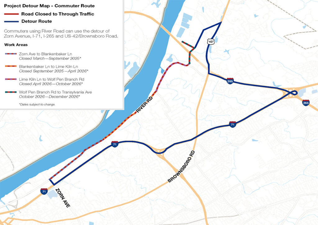
Warmer temperatures make us all eager to get out and enjoy the beautiful weather! Naturally many of us think of driving down River Road to the many beautiful parks, great restaurants, businesses, and social clubs near our homes. This year access will be different. This is not by my decision or the decision of the many people and businesses located near River Road, the Louisville Water Company has closed a segment of River Road to replace a residual line. This is a major project that will move in segments along River Road and will take approximately two years to complete. I empathize with everyone who is impacted by this closure. I drive River Road daily to commute to work, it is a convenient scenic corridor that leads to downtown and lets me bypass the interstates. It is important to know that while this construction will impact many, we will still have access to the parks, restaurants and businesses during most of the construction. Detour signs may cause confusion and detour routes will change over the course of the project, but for most of the time, access will still exist. When the work is finished, we will have a much safer and reliable source of water.
During the last few weeks my office has been in frequent contact with the Water Company, River Road restaurants, businesses, small cities and HOA’s. We are currently working with the restaurants and business along River Road to provide additional signage to better inform drivers of that restaurants and businesses are still accessible during construction. I want to especially thank Andrew Masterson of Captain Quarters for his support.
Please follow the Louisville Water Company’s project website for the most up-to-date information on partial closures and full closures: https://louisvillewater.com/residuallineproject/ .
Louisville Water Company coordinates their street closures and detours with Louisville Public Works and KYTC. My office will continue to post any updates, including specific routes/detours leading to the fine restaurants on River Road, that we receive from these agencies in the District 16 E-Newsletter. I encourage all to continue visiting these restaurants though this work and appreciate your patience and understanding as we navigate this needed infrastructure improvement. Please do not hesitate to reach out to my office if you have questions. We will do our best to answer them in a timely fashion.
All the best,
Scott Reed
 The Metro Council met Thursday for its second meeting of March. During the meeting, Councilman Khalil Batshon recognized the service of Nick Rodman Legacy Foundation Executive Director Ashley Rodman and announced the naming of Louisville’s newest park in honor of fallen LMPD Officer Nick Rodman. Additionally, Councilman Joseph recognized the achievements of Butler High School student Cesar Garcia, who was recently elected Secretary General at the Kentucky United Nations Assembly (KUNA) Conference.
In addition to the above listed recognitions, the Metro Council took action on the following items:
Mask Ordinance Changes (O-264-24): By a vote of 9 -14, I and the majority of members of the Metro Council were able to stop efforts by a few members of the Metro Council to reduce the effectiveness and ability of LMPD to use the ordinance that prohibits the use of masks in public places for reasons other than religion or health. In reviewing this proposal, members of the Metro Council received testimony from members of LMPD as well as the Mayor’s Office against weakening the ordinance, as well as discussion on the origins of the ordinance in combatting demonstrations by groups that sought to use masks as a means for intimidation as well as a way to prevent people from knowing who is participating in such demonstrations.
Cigar Bar Exemption (O-071-25): I joined the majority of members of the Metro Council who voted 20-6 in favor of an amendment to the current Metro Smoking Ban to allow an exemption for those cigar bars. This ordinance helps to bring common sense to our current ordinance and will help address an identified need by groups associated within the hospitality and tourism industry. The ordinance only allows for smoking in businesses that obtain an annual license, generate at least 15 percent of its annual gross income from the sale of cigars or pipe tobacco and must have signage as well as designated smoke free areas to allow for the delivery of materials by outside vendors.
Nick Rodman Legacy Park (R-030-25): The Metro Council unanimously supported a resolution that will name a new park planned for Lamborne Boulevard in Southwest Jefferson County as the Nick Rodman Legacy Park. This park is expected to open this spring following a year of construction and nearly $2 million in investment.
Zoning Cases Approved: The Metro Council voted to approve zoning cases located on Garden Trace Drive, Race Road, Logan Street and South Preston Street.
The Metro Council does not have meetings scheduled for the next two weeks. Our next regular committee week will start on April 14, 2025. The Metro Council’s next meeting will be the Mayor’s Budget Address, which will start at 4pm and will mark the start of the Fiscal Year 2026 Budget process. https://louisvilleky.primegov.com/public/portal
The Louisville Metro Office of Planning published proposed changes to the Land Development Code (LDC) for Homeless and Crisis Shelters as directed by Resolution No. 019, Series 2024 on March 25, 2025. This resolution requested that the Planning Commission (Office of Planning) review the Metro LDC regulations concerning Homeless Shelters and Crisis Shelters and consider changes to “permit more Homeless Shelters with Standards instead of requiring a Conditional Use Permit and to create an option for Temporary Crisis Shelters for when there is a temporary but urgent need for additional shelter space.”
The Office of Planning presented research findings, including a peer city review to the Louisville Metro Council on May 7, 2024 and followed up with five (5) Community Listening Sessions in August/September of 2024.
A summary of the proposed changes is available online HERE. Please share with others and submit comments or questions online HERE. Also, don’t forget to visit the Office of Planning online at https://louisvilleky.gov/planning to learn more about these changes and much more!
To speak directly with a planner, please contact Joel Dock at (502)574-5860 or joel.dock@lousivilleky.gov.
Homeless and Crisis Shelters - Summary of Changes to the LDC_032525.pdf
Looking for activities to keep kids and teens entertained during your spring break staycation? Check out all of the free programs being offered at the Louisville Free Public Library.
Starting Saturday, March 29, LFPL will offer more than 100 free programs and activities to help keep kids and teens engaged and entertained while school is out. LFPL offers hands-on learning programs for children to play, create, and explore together, including interactive storytimes, crafts, nature play, a puppet show, and STEAM activities at locations across Louisville. Families can also enjoy free presentations and performances at the Library from Kentucky Shakespeare, the Little Loomhouse, Brightside Louisville, Jefferson Memorial Forest, and the Louisville Orchestra.
Special events include a Wonder Women Showcase at Shawnee Library (Saturday, March 29, 2 p.m., Shawnee Library, for ages 5-12), a Minute-To-Win-It Challenge at the Northeast Regional Library (Friday, April 4, 2 p.m.), and Lotería Bilingüe/ Bilingual Bingo at Iroquois Library (Thursday, April 3, 6 p.m.). Louisville Orchestra’s “Once Upon An Orchestra,” an interactive storytelling through music performance, will bring the children’s book Bunny’s Book Club to life at the Jeffersontown Library (Saturday, March 29, 10:30 a.m.). Then Kentucky Shakespeare will present a two-actor, family-friendly performance of the Bard’s A Midsummer Night’s Dream at the Northeast Regional Library (Saturday, March 29, 2 p.m.).
Teenagers can also participate in a variety of projects at branches around town, or just hang out and meet other teens in a safe space. Planned activities include Adulting 101: Finance Basics (Tuesday, April 1, 6 p.m., Northeast Regional Library), tabletop Role Playing Games (Saturday, April 5, 12:30-2:30 p.m., South Central Regional Library), and a Teen Movie Matinee (Thursday, April 3, 3 p.m., Highlands-Shelby Park).
The Library also offers kids and teens access to thousands of books, eBooks, graphic novels, blockbuster movies, and popular music – available free with a library card.
Spring Break at the Library runs March 29 through April 6. For a complete list of programs and more, go to LFPL.org/SpringBreak.

Pop-Up Drop-Offs are free recycling and large item disposal events for residents of Jefferson County. Every year these events have recycled more material! The landfill diversion rate (percentage of material that was kept out of the landfill) for 2024 events was 54.4%!
Our first event of the year is on Saturday, March 22 at Shawnee Park! These events are monthly through November. These events are popular and well-attended. Follow these tips for your best experience:
Tip #1: Do not arrive early! All Pop-Up Drop-Off events start at 10 a.m. A line of vehicles causes traffic backups and prevents our equipment from entering.
Tip #2: Only bring sensitive documents to be shredded! The line for shredding is usually the longest. We have seen catalogs, paperback books, etc. being shredded, which is unnecessary and takes up valuable time.
Tip #3: Make sure no items are mixed with your documents! We've seen hammers, scissors, and toys mixed in with documents. These contaminants can break the shredding truck's equipment!
Tip #4: Try giving away usable items first! We see a LOT of decent items being trashed or recycled at our events. Some residents even offer these items to workers - staff is not allowed to keep items. Please try to donate or give away BEFORE coming to our waste and recycling event.
Tip #5: Loads of construction materials, lumber, and loose debris are NOT allowed! Take these loads to the Waste Reduction Center at 636 Meriwether Ave instead. Pop-Up Drop-Off events are very popular - please follow the rules so we can keep the line moving.
Tip #6: Separate your loads into the various categories! More can be recycled and the line moves faster when you are ready to offload your items at each station.
Tip #7: Check-in staff will ask for your zip code and which types of items you brought. We track this information so we can keep improving our events. Most residents bring large items, electronics, and documents for shredding. Other categories include metal (or mostly metal) items, tires, yard waste, household recyclables, prescription medication, and shoes.

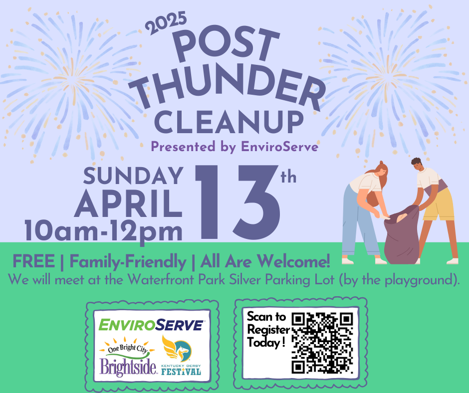 Brightside has partnered with the Kentucky Derby Festival to help clean up a portion of the Waterfront Park from the Big Four Bridge to the University of Louisville Rowing House. Help clean up Waterfront Park after the Thunder Over Louisville festivities!
Everyone will meet at the parking area near the base of the Big Four Bridge at 9:45am for instructions and cleaning will begin at 10am. This is a rain or shine event so please come dressed appropriately for the weather and with close-toed shoes. Brightside will provide litter bags, gloves, and post-event bag collection. For more information or to register for the event, visit www.brightsideinc.org or call (502) 574-2613.
 |
|
Saturday, April 19th | All Day! All Over Louisville!
Time to get out and give our city a nice Spring cleaning! Join thousands of Louisvillians as we all Clean Up together! As always, clean up supplies and post-cleanup bag collection are provided and all are welcome to participate.
Special thanks to our returning sponsor WM, for their continued support and generosity. Their commitment to helping keep our city cleaner and safer for all of us is exemplified through their partnership with Brightside and our volunteers!
|

Public invited to review and comment on preliminary roadway designs
LOUISVILLE, Ky. (March 12, 2025) – The Kentucky Transportation Cabinet (KYTC) will hold a public meeting Thursday, April 10, to update residents and gather input on preliminary designs for the KY 2050 (Herr Lane) improvement project in Jefferson County.
The highway improvement project will improve mobility and vehicular access and enhance safety while upgrading pedestrian facilities along the corridor from the KY 2050 (Herr Lane) and KY 1447 (Westport Road) intersection to Glen Arbor Road. The proposed design includes widening KY 2050 (Herr Lane) and incorporating pedestrian amenities to accommodate all roadway users.
The meeting will be an open house event held from 5 to 7 p.m. at Kammerer Middle School, 7315 Wesboro Road, 40222. Those who are interested may drop in at any time to review the preliminary designs, receive handouts containing project information, and fill out comment sheets. Representatives from KYTC and the engineering design consultant will be in attendance to answer questions.
Following the public meeting, an online survey will be available. After considering public feedback, the final design phase will take place over the next year.
All written comments will become part of the official meeting record. Once compiled, the meeting record and supporting documentation will be made available for review and copying only after an Open Records Request has been received and approved. All Open Records Requests must be submitted to the Transportation Cabinet, Office of Legal Services, Transportation Office Building (200 Metro St, Frankfort, KY 40622), or via kytc.openrecords@ky.gov.
Project scheduled for completion in Fall 2025
LOUISVILLE, Ky. (Feb. 28, 2025) – Preliminary work will begin next week on replacing the Interstate 64 East and West bridges over the Middle Fork of Beargrass Creek in Louisville. The project will be completed in multiple phases and is anticipated to be completed in Fall 2025.
The project includes demolishing and replacing the two existing bridges, located at mile point 11.799, near Exit 10 (Cannons Lane) on I-64 West and Exit 12 to Interstate 264 (Watterson Expressway) on I-64 East.
Lane closures and traffic shifts will occur during the project's initial phase, with two 11-foot lanes maintained in each direction. Once shoulder work is complete, eastbound and westbound traffic will be shifted to the outside shoulder while work occurs in the median. Following the completion of the median work, eastbound traffic will remain on the outside shoulder, and westbound traffic will be shifted to the median between Breckenridge Lane and Browns Lane to accommodate the removal and replacement of the westbound bridge. Work on the westbound bridge will begin in mid-May and be completed by July 2025.
The final phase, which includes demolishing and constructing the eastbound bridge, is expected to be completed by Fall 2025. During this phase, motorists will be shifted to the newly completed westbound bridge and median between Breckenridge Lane and Browns Lane.
The work is being completed by E&B Paving, LLC. of Jeffersonville, Ind., under a $6.6 million contract. Motorists should anticipate lane closures and traffic shifts as construction progresses. Traffic impacts will be shared via District 5's weekly Roadshow report, which outlines all traffic impacts related to major projects and maintenance work.
 The annual pothole blitz will kick off Thursday, March 6! We are seeing exponentially more potholes right now than we typically have in the past several years because of record breaking amounts of snow fall and freezing for an extended period this snow season. We are prioritizing filling pot holes on major roadways (high volume/high speed – like Shelbyville road and Dixie Hwy), roadways that have excessive potholes, and responding to potholes submitted to 311.
Please be vigilant when driving:
-
Stay Alert! Keep an eye on the road ahead and watch for potholes.
-
Maintain a Safe Distance. Leave enough space between you and the car ahead so you have time to react to potholes.
- 3. Slow Down! If you can’t avoid a pothole, reduce your speed before hitting it. Hitting a pothole at high speed increases the impact force.
-
Avoid Sudden Braking. Braking hard just before hitting a pothole can push the front of your car down, making the impact worse.
-
Keep Tires Properly Inflated. Underinflated or overinflated tires are more vulnerable to damage. Check your tire pressure regularly.
Report a pothole through Metro311. Choose "Pothole" and enter the address along with a description if needed.
New items or changes in project status are shown in bold
Inclement weather or other unforeseen circumstances may arise, and as such, the information provided below is for advisory purposes only and subject to change without prior notice.
| I-Move KY |
|
| I-265 (Gene Snyder Freeway) |
- Saturday, March 29, from 7 a.m. to 3 p.m.
- The I-265 North (Gene Snyder Freeway) off-ramp at Exit 34 (to KY 22/Brownsboro Road) will be closed.
- Sunday, March 30, from 12 p.m. to 12 a.m.
- I-64 East at mile maker 17 (near KY 913/Blankenbaker Parkway) will be reduced to two lanes.
- Beginning Monday, March 31, at 9 a.m. through approximately Wednesday, April 30
- I-265 North (Gene Snyder Freeway) will be reduced to two lanes at mile marker 29 (near KY 3084/Old Henry Road).
- Monday, March 31, from 9 a.m. to 3 p.m.
- I-265 North (Gene Snyder Freeway) at mile marker 27 (near U.S. 60/Shelbyville Road) will be reduced to two lanes.
|
| Jefferson County |
|
| I-64 East |
Traffic Impacts: Closure of the right lane.
Date/Time: Daily from 9 a.m. to 3 p.m. and nightly from 6 p.m. to 10 p.m. beginning Monday, March 31, through Friday, April 4.
Type of Work: Routine maintenance of the highway.
Other Details: Motorists should heed signage and use caution when traveling through the work zone.
|
| I-64 East and West |
Traffic Impacts: Shoulder closures are possible.
Date/Time: Daily and nightly.
*Major work will begin in mid-May.
Project Limits: I-64 East and West at mile point 11.799, near Exit 10 (Cannons Lane) on I-64 West, and near Exit 12 to I-264 (Watterson Expressway) on I-64 East.
Type of Work: Bridge replacement project.
Other Details: The contractor is expected to begin mobilizing equipment to the median beginning Friday, March 28.
|
| I-65 South (John F. Kennedy Memorial Bridge) |
Traffic Impacts: Closure of the left three lanes.
Date/Time: The existing lane closures are expected to remain in place until the expansion joint has been fully replaced as part of the expansion joint replacement project. Once the expansion joints have been fabricated, more details regarding the project's timing will be shared.
Project Limits: I-65 South (John F. Kennedy Memorial Bridge).
Other Details: Motorists traveling southbound on I-65 from Indiana should plan for merging traffic, expect delays, or seek alternate routes by using navigation apps such as Waze. The project is expected to be completed by April 2026, with intermittent lane closures to be anticipated throughout the duration of construction.
|
| KY 841 North and South (Gene Snyder Freeway) |
Traffic Impacts: Right lane closures.
Date/Time: Beginning at 7 p.m. on Tuesday, March 25, through 5 a.m. on Wednesday, March 26.
Project Limits: KY 841 North and South (Gene Snyder Freeway), between mile points 35.0 and 37.7, near and through the East End Tunnel.
Type of Work: Routine maintenance of the roadway and East End Tunnel.
Other Details: Motorists should heed signage, use caution, and adjust commutes to accommodate the lane closures.
|
| KY 864 (Logan Street/Shelby Street) |
Traffic Impacts: Sidewalk and lane closures are possible.
Date/Time: Daily and nightly.
Project Limits: Between Goss Avenue and East Gray Street.
Type of Work: One-way to two-way conversion of the roadway.
Other Details: Work is underway ahead of asphalt resurfacing and the two-way conversion of the roadway.
*Work was temporarily paused on this project as KYTC engineers coordinated with contractors to reduce utility conflicts along the corridor. Major work is expected to resume this Spring, with full completion expected by the Spring of 2026.
|
| KY 1531 (Johnson Road) |
Traffic Impacts: Single lane closures with flagging measures are possible.
Date/Time: Daily from 9 a.m. to 3 p.m. beginning Monday, March 31.
Project Limits: KY 1531 (Johnson Road) from the railroad crossing on KY 1531, extending north to Aiken Road (from mile point 9.799 to mile point 11.789).
Type of Work: Base failure repairs ahead of asphalt resurfacing project.
|
| KY 1819 (Billtown Road) |
Traffic Impacts: Lane closures and delays are possible.
Date/Time: Daily – 9 a.m. to 4 p.m.
Project Limits: Three sections of KY 1819 (Billtown Road):
- Easum Road through Mary Dell Lane
- Michael Edward Drive through Fairground Road
- Shady Acres Lane through Colonnades Place
Type of Work: Reconstruction of KY 1819 (Billtown Road) from north of Colonnades Place to south of Easum Road with new traffic signals, signal optimization, turn lanes, storage lanes, etc. (varying by intersection based on existing conditions and future traffic projections).
Other Details: The reconstruction project is expected to be completed by the Summer of 2025.
*Project webpage
|
| KY 3084 (Old Henry Road) |
Traffic Impacts: Traffic will be reduced to one lane and shifted into the median.
Project Limits: KY 3084 (Old Henry Road) from Woodmont Park Lane to Old Henry Trail.
Type of Work: Corrective work.
Other Details: Traffic impacts are expected to remain in place through the completion of work. Motorists should heed signage and use caution when traveling through the work zone.
|
| *Various Locations |
Traffic Impacts: Lane closures and delays are possible as a part of a mobile operation.
Date/Time: Overnight hours from 7 p.m. to 6 a.m.
Type of Work: Pavement marker (reflector) replacement and installation.
Other Details: Motorists should be observant of all road work signage and provide plenty of space for slow moving vehicles while traveling through the work zone.
|
| |
|
| Bullitt County |
|
| KY 480 (Cedar Grove Road) |
Traffic Impacts: Changing traffic patterns, lane shifts, and lane closures are possible as construction progresses.
Date/Time: Daily and nightly.
Project Limits: KY 480 (Cedar Grove Road) between I-65 between mile points 0.6 and 1.4.
Other Details: The interchange reconstruction project is expected to be completed by the Fall of 2025.
|
| *Various Locations |
Traffic Impacts: Lane closures and delays are possible as a part of a mobile operation.
Date/Time: Overnight hours from 7 p.m. to 6 a.m.
Type of Work: Pavement marker (reflector) replacement and installation.
Other Details: Motorists should be observant of all road work signage and provide plenty of space for slow moving vehicles while traveling through the work zone.
|
| |
|
| Franklin County |
|
| U.S. 60X (Singing Bridge) |
Traffic Impacts: Closure.
Other Details: As a precaution to ensure the safety of motorists and pedestrians, the Singing Bridge is closed until further notice.
The recent routine inspection of the 130-year-old bridge found significant structural deterioration that affects the bridge's weight-carrying capacity, prompting state engineers to close the bridge to all travel.
Further assessments and evaluations are needed to determine the next step. Currently, there is no estimated timeframe for the bridge's reopening.
*Press release
|
| I-64/U.S. 127 Interchange |
Traffic Impacts: Lane closures and traffic shifts are possible.
Date/Time: Nightly.
Project Limits: The I-64/U.S. 127 interchange.
Type of Work: The realigning of the I-64 West off-ramp to U.S. 127 North and the I-64 West on-ramp from U.S. 127. Other improvements include the installation of a new signalized intersection on U.S. 127 to provide access to development entrances, which will be activated following project completion. Additionally, the intersection of Westridge Drive and Leonardwood Drive will be reconstructed to accommodate dual left turns onto Westridge Drive from U.S. 127.
Other Details: Traffic is now in its final configuration. The interchange reconstruction project is expected to be completed by the Summer of 2025.
*Press release
|
| U.S. 421 (Bald Knob Road) |
Traffic Impacts: Nightly road closures.
Date/Time: Nightly from 6 p.m. to midnight beginning Monday, March 24, through Monday, April 7.
Project Limits: U.S. 421 (Bald Knob Road) to KY 1570 (St Johns Road).
Type of Work: Base failure repairs and cross drain replacements ahead of an upcoming resurfacing project.
Other Details: Motorists should follow posted detours around the affected area while work is underway.
|
| KY 1685 (Bedford Road) |
Traffic Impacts: Road closure.
Date/Time: Beginning Tuesday, March 4, through Monday, March 31.
Project Limits: KY 1685 (Bedford Road) at the intersection of U.S. 460 (Georgetown Road) at mile point 1.5, and KY 1685 (Bedford Road) at the intersection of U.S. 421 (W Leestown Pike) at mile point 11.4.
Type of Work: KYTC crews will clear debris and repair the roadway following recent weather events.
Other Details: Local thru traffic only.
|
| *Various Locations |
Traffic Impacts: Lane closures and delays are possible as a part of a mobile operation.
Date/Time: Overnight hours from 7 p.m. to 6 a.m.
Type of Work: Pavement marker (reflector) replacement and installation.
Other Details: Motorists should be observant of all road work signage and provide plenty of space for slow moving vehicles while traveling through the work zone.
|
| |
|
| Oldham County |
|
| *Various Exit ramps |
Project Limits: Various interchange Exit ramps on I-71.
Type of Work: Installation and upgrade of wrong-way pavement markings and signs.
Other Details: The Highway Safety Improvement Project will install and enhance wrong-way signs and pavement markings on interstate Exit ramps to discourage wrong-way driving. Motorists should reduce speeds and obey traffic control while workers are present. This project is expected to be completed by the Fall of 2025.
|
| |
|
| Spencer County |
|
| KY 1633 (Elk Creek Road) |
Traffic Impacts: Daily and nightly road closures.
Date/Time: Daily from 9 a.m. to 2 p.m. | Nightly from 6 p.m. to 12 a.m. beginning Monday, March 3, through Monday, March 31.
Project Limits: KY 1633 (Elk Creek Road) from mile point 1.7 to mile point 3.499. *Crews will work in sections.*
Type of Work: Cross drain replacements ahead of an upcoming resurfacing project.
Other Details: Following the replacement of the cross drains, crews will place a layer of dense-grade rock over it until asphalt can be laid. Drivers should exercise caution when driving over the newly replaced cross drains.
|
| |
|
| Shelby County |
|
| I-64 Widening and Improvement Project |
|
| *Various Locations |
Traffic Impacts: Lane closures and delays are possible as a part of a mobile operation.
Date/Time: Overnight hours from 7 p.m. to 6 a.m.
Type of Work: Pavement marker (reflector) replacement and installation.
Other Details: Motorists should be observant of all road work signage and provide plenty of space for slow moving vehicles while traveling through the work zone.
|
| |
|
| Henry County |
|
| *Various Exit ramps |
Project Limits: Various interchange Exit ramps on I-71.
Type of Work: Installation and upgrade of wrong-way pavement markings and signs.
Other Details: The Highway Safety Improvement Project will install and enhance wrong-way signs and pavement markings on interstate Exit ramps to discourage wrong-way driving. Motorists should reduce speeds and obey traffic control while workers are present. This project is expected to be completed by the Fall of 2025.
|
| |
|
| Trimble County |
|
| KY 3175 (Sulphur-Bedford Road) |
Traffic Impacts: Road closure.
Date/Time: Tuesday, March 25, from 9 a.m. to 3 p.m.
Project Limits: KY 3175 (Sulphur-Bedford Road) from mile point 3.1 (near Martini Lane) to mile point 4.0 (near Hoskins Lane).
Type of Work: Cross drain replacement ahead of an upcoming asphalt resurfacing project.
Other Details: Motorists should follow posted detours around the affected area while work is underway. |
| 2025 Resurfacing Projects |
*Resurfacing projects will begin on or after April 1, 2025, and will be completed by the Fall of 2025. Motorists should heed signage and use caution when traveling through the work zone.* |
| |
|
| Jefferson County |
|
| KY 2830 (Arthur Street) |
Project Limits:
KY 2830 (Arthur Street) east of Brandies Avenue/KY 61 extending north to University Boulevard.
|
| U.S. 31E (Bardstown Road) |
Project Limits:
U.S. 31E (Bardstown Road) at the Bullitt/Jefferson County line, extending south of Colonel Hancock Drive.
|
| KY 1631 (Crittenden Drive) |
Project Limits:
KY 1631 (Crittenden Drive) at the beginning of state maintenance near the I-264 interchange, extending north to U.S. 60A (Eastern Parkway).
|
| KY 1531 (Johnson Road) |
Project Limits:
KY 1531 (Johnson Road) from the railroad crossing extending north to Aiken Road.
|
| KY 61 (Arthur Street) |
Project Limits:
KY 61 (Arthur Street) beginning east of Brandies Avenue extending north to I-65 ramp/East Gaulbert Avenue.
|
| KY 155 (Taylorsville Road) |
Project Limits:
KY 155 (Taylorsville Road) beginning at KY 1747 (Hurstbourne Lane) extending north to KY 1932 (Breckenridge Lane).
|
| KY 329 (Covered Bridge Road) |
Project Limits:
KY 329 (Covered Bridge Road) beginning at U.S. 42 extending east to the Jefferson/Oldham County line.
|
| |
|
| Bullitt County |
|
| KY 1531 (Dawson Hill Road) |
Project Limits:
KY 1531 (Dawson Hill Road) from KY 1319 extending north to the Bullitt/Jefferson County line.
|
| KY 2672 (Knob Creek Road) |
Project Limits:
KY 2672 (Knob Creek Road) from KY 1526 (Brooks Hill Road) extending north towards Lake Elmo Road.
|
| KY 2674 (Stringer Lane) |
Project Limits:
KY 2674 (Stringer Lane) from U.S. 31E extending north to KY 44.
|
| |
|
| Franklin County |
|
| KY 12 (Dry Ridge Road/Flat Creek Road) |
Project Limits:
KY 12 (Dry Ridge Road/Flat Creek Road) from the Shelby/Franklin County line extending east to Harvieland Road.
|
| KY 1570 (St Johns Road) |
Project Limits:
KY 1570 (St Johns Road) from the bridge at mile point 4.2, extending north to KY 12.
|
| U.S. 127 (Wilkinson Boulevard) |
Project Limits:
U.S. 127 (Wilkinson Boulevard) near Hall Street extending north to the south end of the U.S. 127/KY 2261 bridge.
|
| |
|
| Oldham County |
|
| KY 362 (Central Avenue) |
Project Limits:
KY 362 (Central Avenue) from Rosswoods Drive extending south towards KY 146.
|
| KY 329 (Covered Bridge Road) |
Project Limits:
KY 329 (Covered Bridge Road) from KY 329B extending east to mile point 8.754.
|
| KY 1694 (Gum Street) |
Project Limits:
KY 1694 (Gum Street) from KY 329 extending north towards Mason Lane.
|
| U.S. 42 |
Project Limits:
U.S. 42 east of KY 1694 (Gum Street) extending east to the Oldham/Henry County line.
|
| |
|
| Shelby County |
|
| KY 362 (Aiken Road) |
Project Limits:
KY 362 (Aiken Road) from the Oldham/Shelby County line extending east near Webb Road.
|
| U.S. 60 (Frankfort Road) |
Project Limits:
U.S. 60 (Frankfort Road) beginning at KY 395 extending east to the Shelby/Franklin County line.
|
| KY 1408 (Loydsburg Road) |
Project Limits:
KY 1408 (Loydsburg Road) from KY 362 extending west to the Shelby/Oldham County line.
|
| KY 322 (Lucas Road) |
Project Limits:
KY 322 (Lucas Road) from KY 53 extending north to the Shelby/Henry County line.
|
| KY 53 (Mt. Eden Road) |
Project Limits:
KY 53 (Mt. Eden Road) beginning at KY 714/KY 44 extending north to KY 1790 (Hooper Station Road).
|
| |
|
| Spencer County |
|
| KY 1633 (Elk Creek Road) |
Project Limits:
KY 1633 (Elk Creek Road) from KY 1135 (Industrial Road) extending north to KY 55.
|
| KY 1795 (Mill Road) |
Project Limits:
KY 1795 (Mill Road) from Paradise Pointe Road extending east to KY 636.
|
| KY 55 (Shelbyville Road) |
Project Limits:
KY 55 (Shelbyville Road) beginning at KY 155 extending north to the Spencer/Shelby County line.
|
| |
|
| Henry County |
|
| U.S. 421 (Campbellsburg Road) |
Project Limits:
U.S. 421 (Campbellsburg Road) at the I-71 overpass extending to the Henry/Trimble County line.
|
| KY 1360 (Franklinton Road) |
Project Limits:
KY 1360 (Franklinton Road) from KY 22 extending north to Bullitt Hill Road.
|
| KY 241 (Pleasureville Road) |
Project Limits:
KY 241 (Pleasureville Road) beginning at the Shelby/Henry County line extending north to U.S. 421.
|
| |
|
| Trimble County |
|
| KY 1256 (Fisher Ridge Road) |
Project Limits:
KY 1256 (Fisher Ridge Road) from Detmer Lane extending east to KY 625.
|
| KY 3175 (Sulphur-Bedford Road) |
Project Limits:
KY 3175 (Sulphur-Bedford Road) from Hoskins Lane extending north to U.S. 42.
|
We now have a new way for you to map crime around you. Just click here and view our new interactive crime mapping tool for Division 5 & 8 or for each beat in Division 5 & 8. And save it in your favorites to view crime anytime it's updated daily. On the page is a Quickfind tool that allows you to put your address in and subscribe to crime trends, alerts and block watch reports for your police beat. Forward this email to your friends and family!
For further information on Councilman Scott Reed or District 16 please visit www.louisvilleky.gov/government/metro-council-district-16
You can also reach out directly by phone at 502.574.1116 or by email at scott.reed@louisvilleky.gov.
601 West Jefferson Street
Louisville, KY 40202
Having Trouble Viewing this eNewsletter? Click here to view it on the web.
|


