As summer settles in across Wyoming, field season is beginning for geologists at the Wyoming State Geological Survey (WSGS). For the WSGS, warmer weather means more than time outside. It marks the start of another active season of mapping, sampling, field verification, data collection, and project work across the state.
Each year, WSGS projects help improve understanding of Wyoming’s geology, natural resources, and geologic hazards. Many of these projects begin in the field, where geologists examine rocks, measure geologic features, collect samples, verify map contacts, and document evidence that cannot be fully understood from a desk. That work later becomes maps, reports, datasets, and other public resources used by land managers, communities, industry, researchers, policymakers, educators, and the public.
|
Current and recent WSGS work includes geologic hazards research, bedrock and surficial mapping, energy and mineral resource studies, water resource investigations, paleontology projects, and efforts to modernize the way geologic information is produced and shared.
Ongoing projects include surficial geologic mapping in areas such as the Ramshorn and Gannett Peak quadrangles, fault and geologic hazard studies in Yellowstone and central Wyoming, high-resolution geologic mapping in the Medicine Bow Mountains and Ferris Mountains, and continued work to convert older geologic maps into modern digital formats.
Energy and mineral resource projects are also underway, including subsurface stratigraphy work in the Denver Basin, critical mineral investigations in the Medicine Bow Mountains, airborne geophysical surveys in southeastern Wyoming and along the Wyoming–Colorado border, and geochemical studies in the Western Phosphate Field. Water resource projects and fossil preparation and digitization work round out the WSGS’s current project portfolio.
Together, these efforts reflect the broad mission of the WSGS: to study Wyoming’s geologic framework, provide reliable public information, and make geologic data more useful and accessible.
This year, the WSGS is also preparing for a major step forward in how geologic information is organized and delivered online. A new, data-driven WSGS website is in the final stages of development and is expected to launch in mid-summer.
The new site is designed to make it easier for visitors to find information by subject, rather than requiring them to search across separate pages for related news, publications, projects, maps, and data.
Organizing Information by Topic
The new website will use subject-based organization and content tags to dynamically group related materials. That means visitors interested in a topic such as uranium, landslides, groundwater, coal, geothermal resources, or paleontology will be able to find related information in one place.
News releases, project descriptions, publications, maps, and other resources will be connected through the same topic areas, making the site more transparent and easier to navigate.
This approach will also help the WSGS keep content current. As new publications are released, projects are updated, or news items are added, related materials can be grouped automatically with the relevant subject area. For users, the result will be a clearer path to the information they need. For the WSGS, it will provide a more flexible way to communicate the connections between its research, publications, data, and public outreach.
The new website and Data Explorer are closely connected to the same larger goal: making WSGS information easier to find, easier to understand, and easier to use.
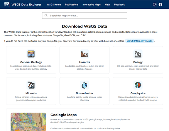
Alongside the new website, the WSGS has also launched the WSGS Data Explorer, a new platform for discovering and accessing the Survey’s geospatial data and mapping resources.
The Data Explorer is designed to serve as a central access point for WSGS GIS data, interactive maps, and related mapping applications. It expands on the WSGS’s existing GIS resources by making data easier to search, preview, download, and use.
Instead of navigating separate download pages organized mainly for experienced GIS users, visitors can explore available datasets and mapping applications through a more visual and searchable interface. Users can search by topic, browse data collections, view maps and applications, and access authoritative WSGS geospatial resources from a single location.
The newly released tool is available at https://main-wyogeosurvey.opendata.arcgis.com. As development continues, it will become an increasingly important part of how the WSGS shares maps, data, and interactive tools with Wyoming residents, agencies, researchers, educators, industry users, and the public.
Making WSGS information easier to find and use
The new website and Data Explorer are closely connected to the same larger goal: making WSGS information easier to find, easier to understand, and easier to use.
Fieldwork remains at the heart of the Survey’s scientific work, but modern data systems help ensure that the results of that work can reach the people who need them. Whether someone is looking for information about a geologic hazard, a mineral resource, a mapping project, an interactive application, or a downloadable dataset, these tools are intended to make the path to that information clearer.
As WSGS geologists head into another field season, the Survey is continuing both its long-standing work of mapping and studying Wyoming’s geology and its ongoing effort to improve public access to geologic information.
From mountain quadrangles and basin studies to digital maps and searchable data, the work underway this season will help build a clearer, more connected picture of Wyoming’s geologic landscape.
|