
New Geophysical Data Released for Southeastern Wyoming
Wyoming State Geological Survey sent this bulletin at 06/24/2026 10:12 AM MDT
Wyoming State Geological Survey
JUNE 24, 2026
FOR IMMEDIATE RELEASE
Media Contact:
Bryce Tugwell, Publications and Outreach Manager
bryce.tugwell@wyo.gov
Wyoming State Geological Survey
Office: (307) 745-2236
www.wsgs.wyo.gov
New Geophysical Data Released for Southeastern Wyoming
LARAMIE, Wyo. — New high-resolution geophysical data collected during an airborne survey across the Laramie Mountains are now publicly available. The data include radiometric and magnetic measurements and will provide critical information for geologic mapping and mineral resource studies.
The survey was designed to optimize coverage of high-interest geologic features, and was funded by the U.S. Geological Survey’s Earth Mapping Resources Initiative (Earth MRI). Data were collected during the summer of 2025, covering approximately 12,600 square kilometers and 71,200 line kilometers.
“These data are the first of their kind in this historically understudied region,” said Dr. Ranie Lynds, interim State Geologist and Director of the Wyoming State Geological Survey (WSGS). “The Laramie Mountains record more than a billion years of Earth’s history, including multiple magmatic and deformation events. Geoscientists will be working with the dataset for decades, and I expect there are many new discoveries yet to be made, ranging from a better understanding of aquifer recharge zones, to mineralized trends, to the region’s broader geologic framework.”
Airborne geophysical surveys are a cost-effective way to collect data on the physical properties of rocks across large areas. Magnetic data reveal differences in rock composition, faults, and magnetic minerals that can be associated with critical mineral deposits. Radiometric data passively measure naturally emitted potassium, uranium, and thorium in the near-surface, which helps scientists map geologic processes and identify potential mineral resources.
The project is focused on the Cheyenne Belt corridor along the southern margin of the Archean Wyoming Province, a region with known and suspected mineral systems with strong potential for critical mineral resources. These new geophysical data are expected to aid regional geologic mapping, guide geochemical reconnaissance projects, and help identify mineral resource potential.
Publicly accessible, high-resolution geophysical data are now available across much of southeast and central Wyoming. This survey is continuous with recently published radiometric and magnetic datasets from nearby regions, including the Medicine Bow Mountains, Sierra Madre–Elkhead Mountains, Shirley Mountains, and Hartville Uplift surveys.
The new dataset is a significant addition to the state’s growing geophysical coverage and geologic understanding of Wyoming's resources. Upon completion and release of all ongoing geophysical survey projects, approximately 20% of Wyoming will be covered by high-resolution magnetic and radiometric data.
The USGS contracted New-Sense Geophysics Ltd. and Merrick-Surdex Joint Venture, LLP to collect magnetic and radiometric data over the Laramie Mountains in two overlapping blocks. Flight lines were spaced 200 meters apart, providing high-resolution coverage across the survey area. The data release includes flight lines, data grids, and a technical report. To download the new dataset, visit the USGS data release page. Map images are also available on the WSGS Mineral Resources interactive map.
For more information on Earth MRI, visit the USGS Earth MRI website. Information about ongoing WSGS minerals projects is available on the WSGS current projects website. A WSGS public information circular on the importance of publicly available geophysical data can be downloaded from the WSGS website.
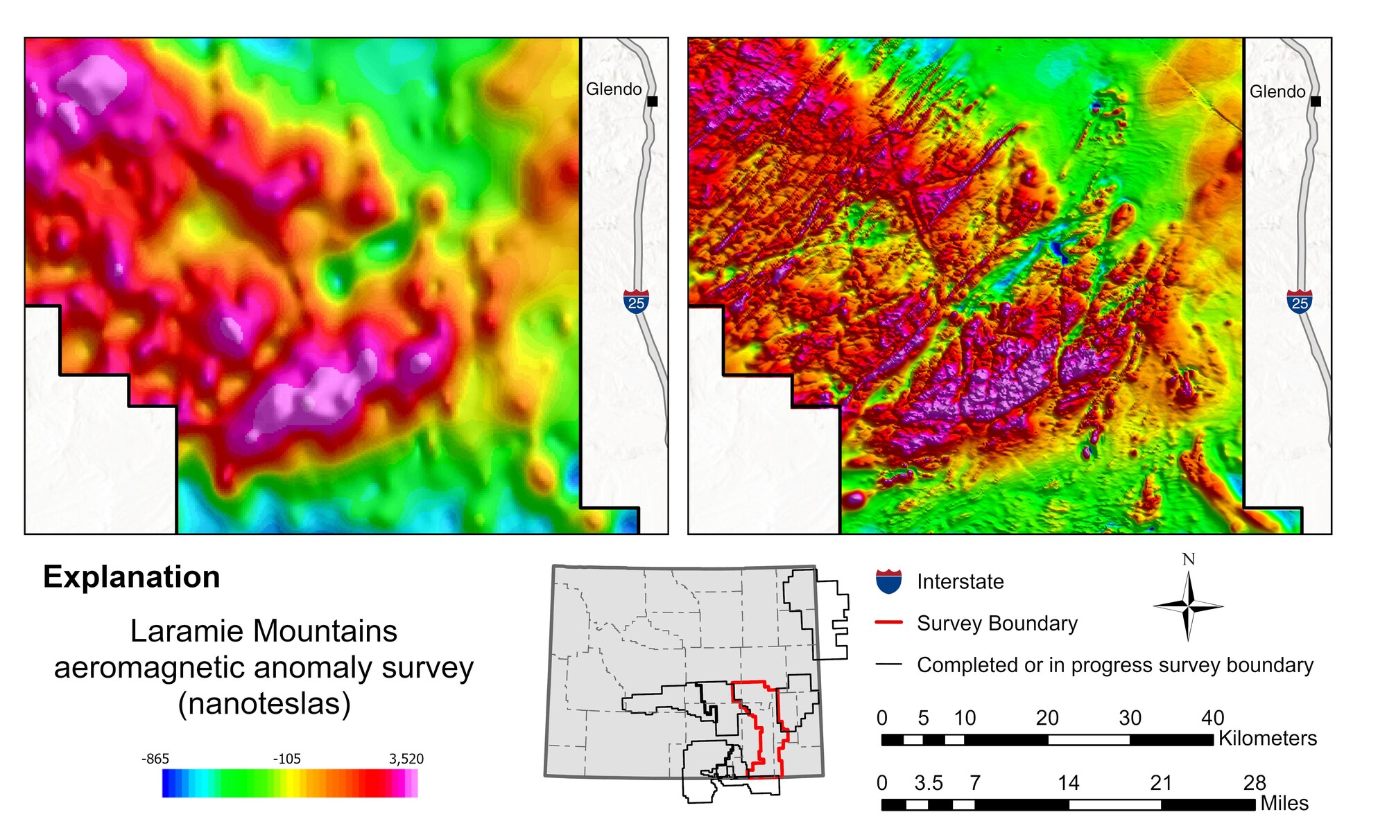 Map of magnetic anomalies from the Laramie Mountains aeromagnetic survey, highlighting anomalies west of Glendo, Wyo. The right panel shows new high-resolution magnetic data, which support more detailed geologic interpretation of the region's geology. The left panel displays older, low-resolution data collected decades ago, useful only for broader regional interpretation. The inset map shows the location of the Laramie Mountains geophysical survey in red and other completed or ongoing surveys in black. Map produced by the WSGS.

|
Exploring the past, empowering the future Email: |
Stay Connected
 |
 |
 |
SUBSCRIBER SERVICES:
Manage Subscriptions | Unsubscribe All | Subscriber Help