
New Geophysical Data Released for Southeastern Wyoming
Wyoming State Geological Survey sent this bulletin at 03/16/2026 08:18 AM MDT
Wyoming State Geological Survey
March 16, 2026
FOR IMMEDIATE RELEASE
Media Contact:
Bryce Tugwell, Publications and Outreach Manager
bryce.tugwell@wyo.gov
Wyoming State Geological Survey
Office: (307) 745-2236
www.wsgs.wyo.gov
New Geophysical Data Released for Southeastern Wyoming
LARAMIE, WY — New high-resolution geophysical data collected during an airborne survey across the Shirley Mountains and Hartville Uplift regions of Wyoming are now publicly available. The data include radiometric and magnetic measurements and will provide critical information for geologic mapping and mineral resource assessment.
The survey was designed to optimize coverage of high-interest geologic features, supporting both geologic mapping and mineral resource studies. It was funded by the State of Wyoming with contributions from private industry and the U.S. Geological Survey’s Earth Mapping Resources Initiative (Earth MRI). Additional airborne data collected through industry funding expanded the overall survey coverage; these data will become publicly available in one year. Data collection was contracted and conducted through Earth MRI during the summer of 2025, covering approximately 15,000 square kilometers.
“The economy of scale for this effort has allowed us all to benefit from increased high-resolution data coverage across the state,” said Dr. Ranie Lynds, interim State Geologist and director of the Wyoming State Geological Survey.
Airborne geophysical surveys are a cost-effective way to detect geologic trends across large areas. Magnetic data reveal differences in rock composition, faults, and magnetic minerals that are often linked to critical mineral deposits. Radiometric data passively measure naturally emitted potassium, uranium, and thorium in the near-surface, which helps scientists map geologic processes and identify potential mineral resources.
The project is focused on the Cheyenne Belt corridor along the southern margin of the Archean Wyoming Province—a region that contains several known and suspected mineral systems with strong potential for critical mineral resources. The survey data are also expected to aid mapping of suspected Laramide and more recent Quaternary faults, as well as geologic elements important to subsurface resources in parts of the Shirley and Denver basins and the Laramie Valley.
The new dataset is a significant addition to the state’s growing geophysical coverage—and geologic understanding—of Wyoming's resources. Upon completion and release of all ongoing projects, approximately 20% of Wyoming will be covered by high-resolution magnetic and radiometric data.
The USGS contracted NV5 Geospatial, Precision GeoSurveys, and EDCON-PRJ to collect magnetic and radiometric data over two data blocks: one covering the Hartville Uplift region, and the other covering the Shirley Mountains region. Flight lines were spaced 200 meters apart for both surveys, flown east-west in the Hartville Uplift block and north-south in the Shirley Mountains block. Data files include flight lines, data grids, and a technical report. To download the new dataset, visit the USGS data release page. Images are also available on the WSGS Mineral Resources interactive map.
For more information on Earth MRI, see the USGS Earth MRI website. Information about ongoing WSGS minerals projects is available on the WSGS current projects website. A WSGS public information circular on the importance of publicly available geophysical data can be downloaded from the WSGS website.
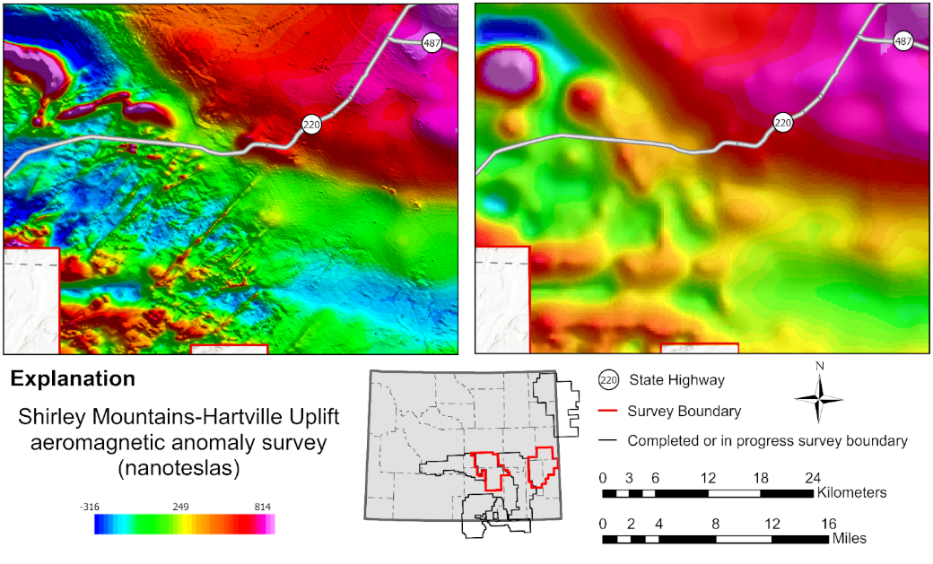
Map of magnetic anomalies from the Shirley Mountains-Hartville Uplift aeromagnetic survey, highlighting anomalies near Pathfinder Reservoir. The left image shows new high-resolution magnetic data, which provides a deeper understanding of the region's geology. The right image displays older, low-resolution data collected decades ago, useful only for large-scale regional interpretation. The inset map shows the location of the entire Shirley Mountains-Hartville Uplift geophysical survey in red and other completed or ongoing surveys in black. Map produced by the Wyoming State Geological Survey.
| |
Exploring the past, empowering the future Email: |
Stay Connected
SUBSCRIBER SERVICES:
Manage Subscriptions | Unsubscribe All | Subscriber Help