|
|
Winter 2025
From ancient maps to digital datasets—explore the WSGS’s latest geologic mapping, resource updates, and fossil discoveries.
|
|

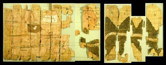
The world’s oldest surviving geological map was created in 1150 B.C.E., illustrating the geology and topography of the central Eastern Desert of Egypt. This map accurately locates sedimentary and igneous rocks, as well as gold-bearing quartz veins, by depicting rock types in different colors and showing hill slopes and mountain locations relative to the geology. It was drawn during the reign of Ramesses IV, to record the king’s “bekhen-stone” quarry. Bekhen-stone is a green metagraywacke that was carved into statues and palettes. This early geologic map was drawn on papyrus, and it was discovered in the 1820s by a looter of antiquities, who collected it from an ancient Egyptian workmen’s village south of the Valley of the Kings.
|
Fragments of Turin papyrus, circa 1150 B.C.E. by Amennakhte
Three thousand years later, the first known geologic maps of Wyoming were created, beginning with the Geologic Map of Western Wyoming by Captain W.A. Jones in 1874, and the 1878 Hayden Geologic Map of Central Wyoming.
The Wyoming State Geological Survey (WSGS) has been publishing geologic maps since its establishment in 1933, and we continue to publish geologic maps today. While these maps still contain the content of geology relative to topography and location, today’s maps offer much more information. We no longer produce only static paper maps; we now release maps in a digital format which can be overlain with any spatial data to help make interpretations clearer and more efficient. Our digital maps are linked to metadata, analyses, and references. And these maps are available at your fingertips anywhere through the WSGS website.
As described in this newsletter, we now release maps in a standardized USGS GeMS format, which allows them to be incorporated in a national database, where they can be used by industry and government clients around the world, immediately available.
The geologic maps the WSGS creates today may be in a different format than those of even 20 years ago, but they are still at the heart of everything we do. Geologic mapping is the first step in the study of geologic resources, hazards, and hydrology. These maps are a product of which we at the survey are very proud.
|
|

The WSGS continues its mission to provide up-to-date geological information with a series of new releases, offering valuable insights into the state's natural resources and geologic framework. The latest publications include fact sheets on Wyoming’s energy sector, a new geologic map of the Firehole Canyon quadrangle, and the launch of a digital dataset publication series. Each of these efforts underscores the WSGS’s commitment to delivering timely, accessible, and high-quality geological information for the public, industry, and policymakers.
|
Annual Uranium, Oil, and Gas Fact Sheets
The WSGS released its annual summaries of Wyoming’s uranium, oil, and natural gas industries in a new format—concise fact sheets, designed to present key data at a glance. The change from a traditional report format provides a streamlined approach to understanding trends in Wyoming’s energy sector.
Wyoming remains a leader in uranium production, benefiting from rising global interest in nuclear energy. Companies are expanding operations, increasing exploration efforts, and hiring additional staff in response to higher uranium prices and shifting geopolitical influences. Meanwhile, Wyoming’s oil industry continues to show resilience despite market fluctuations, while natural gas production remains in a gradual decline due to reduced drilling activity.
These fact sheets provide stakeholders with critical production figures, economic indicators, and industry trends. They are available as free downloads on the WSGS website.
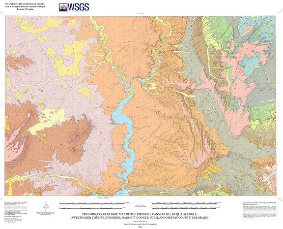
Preliminary geologic map of the Firehole Canyon 30’ x 60’ quadrangle, Sweetwater County, Wyoming, Daggett County, Utah, and Moffat County, Colorado.
New Geologic Mapping in Firehole Canyon Quadrangle
In late 2024, the WSGS finalized a new 1:100,000-scale bedrock geologic map of the Firehole Canyon 30' x 60' quadrangle, covering parts of Sweetwater County, Wyoming, as well as slivers of Utah and Colorado. This mapping effort enhances geological resolution in the region, supplementing previous 1:500,000-scale mapping with new fieldwork and refined data compilation.
The Firehole Canyon quadrangle lies within a geologically diverse area encompassing the Rock Springs Uplift, Bridger Basin, and Uinta Mountains. The map documents sedimentary deposits spanning the Cretaceous through the Eocene, capturing key transitions in Wyoming’s geologic history, from the retreat of the Western Interior Seaway to the development of extensive terrestrial and lacustrine environments.
Economic resources in the mapped region include oil and gas reservoirs, coal deposits, trona, and oil shale formations, along with significant paleontological discoveries. The mapping project was supported through the U.S. Geological Survey’s National Cooperative Geologic Mapping Program.
Launch of Data Release Publication Series
The WSGS has also introduced a new publication series dedicated to standalone digital datasets, making Wyoming’s geological data more accessible and standardized for researchers and industry professionals.
The first data releases in this series feature the Bill and Reno Junction 30' x 60' quadrangles in eastern Wyoming, part of a broader effort to create a seamless 1:100,000-scale geologic database for the state.
Accessing the WSGS Publications
These latest releases highlight the WSGS’s ongoing efforts to modernize geological research and provide timely, authoritative data for Wyoming’s industries and communities. More information, including free downloads of fact sheets, maps, and digital datasets, is available at wsgs.wyo.gov.
|
|
|
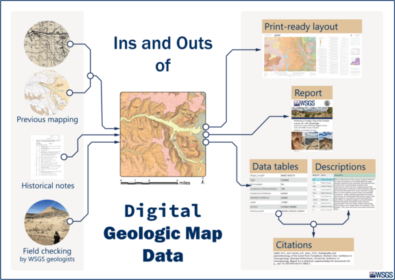
Geologic maps may begin as ink on paper, but the WSGS is committed to transforming these foundational resources into modern digital datasets that retain the full depth of scientific research behind them. By converting legacy maps into digital formats and adopting standardized data structures, the WSGS is ensuring that Wyoming’s geologic information is not only preserved but also made more functional and accessible for researchers, industry professionals, and the public.
One of the agency’s key modernization efforts is the conversion of legacy digital geospatial data for 30 1:100,000-scale bedrock geologic maps into the Geologic Map Schema (GeMS)—a standardized format for storing and sharing geologic map data. This initiative furthers the WSGS’s mission to provide up-to-date, high-quality geological information while working toward the creation of a seamless statewide geologic database.
What is GeMS?
GeMS is a standardized database design developed by the U.S. Geological Survey (USGS) to bridge the gap between traditional paper geologic maps and modern digital datasets. By providing consistent data structures, coding, and symbology, GeMS enables geologic maps to be more easily queried, visualized, and transferred across different platforms and users. For more information, visit the USGS National Geologic Map Database.
Why Standardized Geologic Data Matters
By adopting GeMS, the WSGS is:
-
Ensuring consistency across multiple geological maps at the 1:100,000 scale, unifying data collected by different researchers and methods over the past three decades.
-
Facilitating data integration and analysis by providing common GIS formats that make it easier for geologists, land-use planners, and researchers to interpret geologic features.
-
Enhancing data sharing and interoperability, reducing the need for manual interpretation of geologic units and codes.
-
Improving future mapping efforts by establishing a clear standard for new geologic maps.
 Beyond GeMS: Expanding Digital Mapping Initiatives
The WSGS’s modernization efforts extend beyond GeMS. The agency is implementing broader adoption of open data formats, refining metadata standards, and enhancing interactive mapping services to make geologic data more accessible. Recent upgrades to the WSGS web server will streamline access to digital maps, ensuring seamless functionality whether users are analyzing data from a desktop computer in an office or referencing geologic units from a mobile device in the field.
Additionally, improved user metrics will help the WSGS refine its services to better meet the needs of stakeholders. These ongoing efforts reflect the WSGS’s commitment to making Wyoming’s geologic data accessible, standardized, and reusable—whether for GIS professionals integrating data into their projects, researchers studying the state’s geologic history, or residents simply curious about Wyoming’s diverse landscapes.
Progress and Data Availability
As of February 2025, the WSGS has released 12 quadrangles in the northeastern part of the state, covering key areas in the Black Hills and Powder River Basin region. These include:
Sheridan, Recluse, Devils Tower, Buffalo, Gillette, Sundance, Reno Junction, Newcastle, Bill, Lance Creek, Casper, and Douglas.
|
|

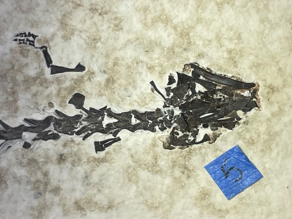
Progress on Salamander Fossil Preparation
In summer 2024, the WSGS announced the discovery of a rare fossilized aquatic salamander from the Fossil Butte Member of the Green River Formation. Since then, work has been underway to carefully prepare and stabilize the specimen for further study. Discovered on state lands west of Kemmerer, the fossil is particularly significant for its exceptional soft tissue preservation—an exceedingly rare feature in amphibians. Among the three known salamander fossils from this formation, this is the first to display such detailed preservation of skin and body structures, offering scientists a unique glimpse into an extinct species from the Sirenidae family.
|
To safely expose these delicate features, the WSGS partnered with expert fossil preparator Mike Eklund. Given the fossil’s small size and fragile nature, preparation requires precision tools, such as fine needle-tipped pin vises and ultra-soft brushes under high magnification. More aggressive techniques, like airscribes or air abrasion, which are commonly used on dinosaur fossils, would risk damaging the soft tissue impressions.
After stabilization, the long preparation process to remove matrix materials obscuring bones and tissues can begin.
Recent updates indicate that preparation is nearly complete, revealing well-preserved bones and soft tissues. The next step is further analysis in collaboration with researchers from Fossil Butte National Monument and the Royal Tyrrell Museum in Canada, helping to expand our understanding of this ancient species.
Mapping Oil and Gas Systems in the Denver Basin
The WSGS geologists are actively mapping oil and gas reservoirs in southeastern Wyoming’s Denver Basin, a major hydrocarbon-producing region that spans Wyoming, Colorado, and Nebraska. This research focuses on both conventional and unconventional reservoirs (low porosity, low permeability systems), including the Pierre Shale, Niobrara Formation, Mowry Shale, and Muddy “J” Sandstone hydrocarbon reservoirs that hold significant oil and gas potential.
The Silo Field in Laramie County, located in southeast Wyoming, for example, has been producing from the Niobrara Formation since 1981. By creating detailed geologic depth and thickness maps of these Cretaceous-age reservoirs, the WSGS aims to provide publicly available data that will help industry professionals, researchers, and policymakers better understand the region’s hydrocarbon resources.
Building a Digital Uranium Database
As interest in uranium resurges, the WSGS has launched a project to modernize Wyoming’s uranium resource data. This effort builds on the Uranium Map of Wyoming (MS-94)—last updated in 2010—by developing a comprehensive digital geodatabase that compiles geologic data, mining infrastructure, production history, and deposit locations.
The updated dataset will be a valuable tool for uranium exploration, reclamation efforts, and public education about Wyoming’s role in uranium mining. Once completed, the data will be available as interactive layers on the WSGS online Mineral Resources Map and as a new data release.
By modernizing this information, the WSGS aims to provide a clear and accessible resource for both industry stakeholders and the general public, ensuring Wyoming’s uranium legacy remains well-documented and useful for future development.
Ongoing Airborne Geophysical Surveys
Airborne geophysical surveys are continuing across Wyoming, providing critical subsurface data to support geological research and resource exploration.
The Laramie Mountains' magnetic and radiometric survey began in fall 2024 and will resume this spring, collecting data on variations in Earth’s magnetic field and naturally occurring radiation from rock formations. Meanwhile, the Cheyenne Belt-Black Hills electromagnetic (EM) survey is now underway, with low-altitude helicopter flights gathering data along the Cheyenne Belt, an ancient suture zone marking the boundary between the Wyoming Province to the north and the Colorado Province to the south. The flight advisory for this survey was issued in January, and the survey helicopter has already been spotted in the Laramie area.
In addition, the Sierra Madre-Elkhead Mountains magnetic and radiometric survey was completed in summer 2024. The USGS has reviewed and approved the collected data, though additional contractor documentation is still pending. Once all necessary materials are received, the dataset will be released to the public through USGS ScienceBase, a digital repository for geologic data.
To help explain the science and applications of airborne geophysics, the WSGS is preparing a Public Information Circular detailing how these surveys are conducted and what insights they provide. This publication will be available in the coming months.
A helicopter equipped with a stinger-mounted magnetometer and gamma-ray spectrometer conducted flights last summer to collect the survey data. EON Geosciences Inc. photo
|
|
Jeremy Ring joined the WSGS as an Oil and Gas Geologist, bringing experience from both the oil and gas industry and academic geology. Originally from Colorado, Jeremy grew up between Denver and Boulder before working in Houston’s energy sector. Drawn back to the mountains and outdoor opportunities of the West, he made his way to Wyoming, where his work now focuses on understanding and mapping the state’s valuable mineral and hydrocarbon resources.
Outside of work, Jeremy enjoys hiking, biking, and skiing—any excuse to be outdoors. His passion for geology extends beyond the office, as he’s constantly exploring Wyoming’s diverse landscapes and geologic formations.
What do you do at the WSGS?
"I’m part of the Energy and Minerals team, where I focus on the geology of Wyoming’s economic deposits. My work covers a range of projects, from characterizing critical mineral occurrences to mapping hydrocarbon resources. It’s a dynamic role that involves everything from gathering rock samples and performing lab analyses to providing input to policymakers."
What makes your job interesting?
"The variety. No two days are exactly the same, but everything is still grounded in geology. I could be in the lab analyzing samples in the morning and then modeling subsurface rock formations in the afternoon. I also love that I’m always learning—by the end of the day, I’ve usually discovered something new, and that's pretty cool to me."
How does your job help Wyoming?
"Mineral and hydrocarbon production is a major part of Wyoming’s economy, supporting jobs and generating tax revenue. I’ve worked on an oil and gas rig in the Powder River Basin before, so I know firsthand how important these industries are. My work at the WSGS provides insight to both the public and industry professionals, helping them better understand the geological controls on these resources. And the best part? The research we produce is freely available to everyone."
What are some of your favorite geologic features in Wyoming and why?
"I’ve always been fascinated by Devils Tower—it’s one of the most striking geologic features out there, and there’s still debate over its origins, which makes for interesting discussions among geologists. But honestly, Wyoming is full of incredible geology. Living between the Medicine Bow and Laramie mountains means I’m never more than a stone’s throw away from something fascinating."
|
|
|
|
|
|