This summer, the Wyoming State Geological Survey (WSGS) will embark on mapping and compilation of the bedrock geology of the Medicine Bow 30' x 60' quadrangle in southeastern Wyoming. The quadrangle exhibits a diverse range of geologic features and has potential critical mineral deposits. Additionally, the Hanna Basin and Saratoga Valley—features in the mapping area—contain known and possibly undiscovered oil, gas, coal, and uranium resources.
The quadrangle is in Carbon and Albany counties, with U.S. Interstate 80 (I-80) roughly bisecting it. In addition to the small towns of Arlington and Elk Mountain, which are along I-80, the quadrangle contains the towns of Hanna and Medicine Bow. A bedrock map of this scale in this region would facilitate scientific study of various geologic topics, such as structural deformation styles of the Laramide orogeny. Geologic features include the Cretaceous and Paleocene rocks that fill the Hanna Basin, Neoarchean and Paleoproterozoic metasedimentary and metavolcanic rocks in the nearby Medicine Bow Mountains, and post-Laramide Miocene rocks of the northern Saratoga Valley.
Compiling a 1:100,000-scale bedrock map for this area will build on ongoing WSGS projects on critical minerals in the Medicine Bow Mountains. The map also supports a long-term WSGS objective to have statewide coverage of bedrock geologic mapping at this scale.
This map is partially funded through the U.S. Geological Survey's National Cooperative Geologic Mapping Program (STATEMAP), and is scheduled to be published in 2026.
|
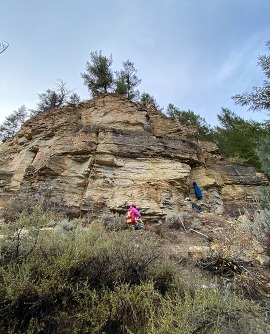
The Earth MRI Phosphoria project took advantage of a warm fall to conduct fieldwork in the western half of the state. Geoscientists sampled and measured sections of the phosphate-rich Meade Peak Member of the Permian Phosphoria Formation in areas around Jackson, and visited prospective sites near Afton and Lander.
The Phosphoria project is through the U.S. Geological Survey’s Earth Mapping Resources Initiative (USGS Earth MRI) program. It is a four-state cooperative effort, administered by the Idaho Geological Survey, to evaluate enrichment of critical minerals in the Permian Phosphoria Formation. Often referred to as the Western Phosphate Field, this region in Wyoming, Idaho, Utah, and Montana is one of the largest commercial resources of phosphate rock worldwide. Phosphorus has been mined in the area for the fertilizer industry since the early 1900s.
The first batches of samples have been submitted to the USGS for geochemical analyses, and while the team waits for data, they are busy planning fieldwork for the upcoming summer. Plans include additional sampling at last summer's sites and new locations near Dubois and Cokeville. Geochemical and detailed stratigraphic measurements will give a regionally representative framework for understanding the occurrences and distributions of critical minerals, especially rare earth elements, within the Phosphoria Formation.
(Caption: WSGS geologists sample the Meade Peak and Rex Chert members of the Phosphoria Formation at a site along the Gros Ventre River. The Meade Peak Member of the Phosphoria Formation contains phosphate-rich mudstone, carbonates, and shales, which weather easily, forming soft slopes. The overlying units are much more resistant to weathering, and form prominent ledges above the Meade Peak slope. The Meade Peak is overlain by the Rex Chert member of the Phosphoria Formation, above which are interfingering sandstones and dolomites of the Park City Formation and the Shedhorn Sandstone.)
|
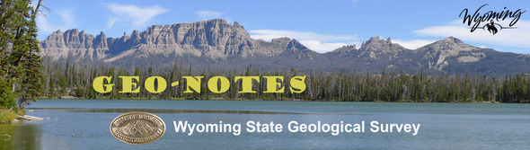
The WSGS is mapping two 1:100,000-scale bedrock geologic maps of the Red Desert Basin and Rawlins 30' x 60' quadrangles. The quadrangles occupy nearly all of the Great Divide Basin, and span an area between Rawlins and Rock Springs in southwestern Wyoming.
Geologists spent time in the field last summer and fall collecting data for the maps. The team includes WSGS geologists Chris Doorn and Derek Lichtner, seen in the photo below discussing a fault offsetting Cretaceous strata above Potash Wash on the Red Desert Basin quadrangle. The gray hills stretching into the background are composed of the Lewis Shale, and the white-tan cliffs in the middle ground are composed of the younger Fox Hills Sandstone. The Fox Hills Sandstone has been down-dropped to the north (left) along the fault, which cuts through the shaded notch left-of-center on the horizon.
Both maps are produced through the STATEMAP program, and they are scheduled to be released in 2025.
The WSGS is working closely with geoscientists from the USGS Earth MRI program to collect and distribute high-quality airborne geophysical data for much of Wyoming.
Hard rock mineral exploration is an expensive and risky business. Wyoming has favorable geology for significant deposits of economic minerals, yet much of those potential deposits lie under layers of sediment. Airborne geophysics surveys, including magnetics, radiometrics, and electromagnetics, are the most cost-effective way for geoscientists to “see through” these sediments and delineate potential subsurface mineral deposits. Comprehensive, high-quality, public airborne geophysical data reduces exploration risk, attracting statewide investment.
Mineral exploration is just one use for these types of data. Similar programs internationally have been used to determine radon hazards, near-surface faults, delineate karst hazards, and improve groundwater management. Improved mapping of complex older fault systems and basin structures enhances the structural framework necessary for non-critical mineral resource research, including hydrocarbons and associated byproducts, carbon storage, water, and uranium.
As of May 2024, there are three aeromagnetic and radiometric surveys in Wyoming. All were or are flown by helicopter with 200-meter line spacing and 100-meter ground clearance, making them the first publicly available high-quality datasets in Wyoming.
South Pass-Granite Mountains: This 8,640-square-kilometer survey was flown during summer 2023, and the data were released to the public in February. Some of the data can be viewed at lower resolution on the WSGS Mineral Resources of Wyoming interactive map. The raw data can be downloaded from the USGS ScienceBase Catalog.
Medicine Bow Mountains: This 2,683-square-kilometer survey was flown in summer 2023. The data were delivered to the USGS and are in preparation for release through the ScienceBase Catalog. Stay tuned for more information from the WSGS once these data are available.
Sierra Madre-Elkhead Mountains-Medicine Bow Mountains: Contractors began flying this 12,950 square kilometer survey—straddling the Wyoming-Colorado border region—during the fall of 2023. About 19% of the survey was flown when winter weather closed down operations for the season. Helicopter flights will resume when the snow melts with estimated completion during late summer or fall of 2024. As with the other geophysical surveys, these data, once checked by the USGS, will be released for public use through the ScienceBase Catalog.
To learn more about geophysical data being collected across the United States, check out the Earth MRI Acquisitions Viewer.
Have you checked out the new WSGS website—https://main.wsgs.wyo.gov—yet? It features a modern look and is easier to access from a mobile device.
“While our website may look different, its objective remains unchanged, and that is to share Wyoming’s unique geology,” Dr. Erin Campbell, WSGS Director and State Geologist, said in a news release. “The website is one of the main ways we engage with residents, visitors, educators, industry, government, and anyone interested in our state, and we hope these improvements benefit those interactions.”
The new website remains a work in progress, and the WSGS welcomes your feedback. Please send suggestions to Christina George at christina.george@wyo.gov.

Katie Lyon—GIS Coordinator, Map Editor, hired in 2024
Katie Lyon is the newest member of the WSGS team. Originally from Norfolk, Neb., Katie earned a bachelor’s and master’s degrees in human dimensions of natural resources from Colorado State University. Her hobbies include Husker sports, reading, gardening, composting, and anything she can do outdoors with her Aussie dog Alta—paddle boarding, hiking, running, and cross-country skiing.
Prior to joining the WSGS, Katie managed two national inventory and monitoring projects (visitor survey and trail inventory) for the U.S. Fish & Wildlife Service including data design, field data collection, data processing, and preparing reports and digital products.
What do you do at the WSGS? As the new GIS coordinator and map editor, I support staff in their mapping and geospatial database publication efforts. I am responsible for creating and maintaining cartographic and GIS templates and procedures, editing map layouts, and ensuring our spatial data complies with federal data standards. I also manage the interactive Geologic and Topographic Map Index of Wyoming, which provides up to date status and availability of maps produced by the Wyoming State Geological Survey and the U.S. Geological Survey.
What makes your job interesting? I love organizing and analyzing data, and so far my job has not disappointed in this regard. As a non-geologist, I am beginning to learn more about Wyoming and the places I visit through a geology lens. I also enjoy being part of a team and look forward to contributing to a variety of projects.
How does your job help Wyoming? My job is to make our maps and data accessible and usable, which is vital to providing awareness and understanding of Wyoming’s geologic, mineral, and energy resources.
What are some of your favorite geologic features in Wyoming and why? It feels cliché but the Tetons— their jagged peaks and light and dark layers of gneiss are a favorite not only for their stunning vistas but they hold a lot of memories for me from family trips to outdoor adventures floating the Snake River and climbing the Grand. Titcomb Basin in the Wind River Range is another favorite for its clear alpine lakes surrounded by granite peaks and vast glacier-cut valleys. The Sinks and Rise in Sinks Canyon State Park outside of Lander is also pretty neat!
|
- The WSGS will be at the 2024 Wyoming State Mineral and Gem Show, 10 a.m.–6 p.m., May 30–31, and 9 a.m.–5 p.m., June 1, at the Park County Fairgrounds in Powell. This year's show theme is minerals in Wyoming. WSGS geologists will be bringing an X-ray fluorescence machine that helps identify rocks and minerals; geologist Chris Doorn is slated to give a talk on critical minerals in Wyoming during the event as well. More information can be found here.
- Geologists are scheduled to give tours of the English Tunnel at South Pass City during Gold Rush Days July 6–7. The tunnel was started in the 1860s as an exploratory tunnel looking for gold-bearing quartz veins. More details about the event will be posted here.
- On July 13, from 10 a.m. to 2 p.m., the WSGS will be at Dino Day at the Wyoming State Museum in Cheyenne. Visit the Survey's table to learn about the Wyoming State Dinosaur, the triceratops. Learn more about the event here.

For the past several years the Wyoming State Museum in Cheyenne has hosted “Dino Day” as part of its Family Days events. This year Dino Day falls on July 13, and the WSGS will be there sharing about the state dinosaur—the triceratops. As fascinating as the dinosaurs are themselves, their catastrophic demise is equally interesting from a standpoint of scientific deduction.
Dinosaurs lived during the Mesozoic Era, which ended about 66 million years ago. Mesozoic means “middle life,” and this era includes the Triassic, Jurassic, and Cretaceous periods. At the end of the Cretaceous Period (known as K, for short), something occurred to cause a major extinction, which killed the dinosaurs and 80 percent of life on Earth. This time period was followed by the Cenozoic Era, which started with the Paleogene Epoch, formerly known as the Tertiary. In the rock record, this change from the Cretaceous (K) to the Tertiary (T), also known as Paleogene (Pg), is called the K-T boundary or K-Pg boundary.
The K-Pg boundary is significant because before it, during the Cretaceous, we find fossils of dinosaurs, large marine reptiles, diverse plant species, and a wide variety of single-cell ocean organisms called foraminifera. In the stratigraphy at the K-Pg boundary, there is a distinct change in rock type, and in the younger rocks above it there are no dinosaur or large reptile fossils, 60 percent of all plant species are missing, and fossils of only a few species of very small foraminifera can be found.
Geologists and physicists around the world worked to solve the mystery of what happened between the Cretaceous and the Paleogene. In addition to the change in the fossil record, at the K-Pg boundary scientists also noticed an abnormal abundance of one of the rarest elements on earth—iridium. Up to 30 times more than normal iridium was found at the K-Pg boundary. Iridium is found in cosmic dust, comets, asteroids, and meteorites. In order to generate this much iridium, the earth would have to have been struck by an enormous meteorite.
Geologists began to look for evidence of this meteorite. They found indications of a colossal impact, including shocked quartz—quartz crystals deformed by intense pressure—and tiny spherules of rock (tektites) that had been vaporized and cooled like droplets of molten glass. But where was the impact crater?
A geophysicist working in the petroleum industry identified the impact crater through a geophysical survey over the Gulf of Mexico. This geophysical survey was recording the magnetic strength of seafloor rocks, and the geophysicist noticed a large semicircular arc on the seafloor. Those magnetic data, verified by gravity (density) data, confirmed the discovery; there was an enormous impact located over the Yucatan Peninsula in Mexico, which was named the Chicxulub Crater for the local city.
The K-Pg meteorite impact was devastating. The meteorite, estimated to be over 6 miles in diameter and weighing hundreds of billions of tons, was moving at 36,000 miles per hour—fast enough to fly from New York to Los Angeles in less than 5 minutes. It created a crater 110 miles in diameter, roughly the distance from Casper to Laramie, and 12 miles deep, which is 10 times the depth of the Grand Canyon.
The energy released at impact was equivalent to 10 billion Hiroshima atomic bombs. Huge tsunamis moved across the Gulf of Mexico and Caribbean Sea. All life forms not immediately killed by the impact were later affected by the dust cloud that blocked sunlight around the world, stopped photosynthesis, and collapsed the food chain. This is why the rocks above the K-Pg boundary have so few fossils; many forms of life died during or shortly after this event.
There are a few locations in Wyoming's Powder River Basin where you can see the K-Pg boundary between the Cretaceous Lance Formation and the Paleogene Tullock Member of the Fort Union Formation. It can be seen at Dogie Creek northwest of Lusk, at a locality north of the former town of Sussex, and near Teapot Dome east of Teapot Rock. It’s amazing to think that this thin zone of clay, about 2 centimeters thick, tells the story of the event that so drastically changed life on planet Earth.
--Dr. Erin Campbell, WSGS Director and State Geologist
|
|