|
The Wyoming State Geological Survey (WSGS) published a new geologic map of the Phantom Lake quadrangle in the Medicine Bow-Routt National Forest. The map contributes to a much larger effort in understanding mineral potential in the state as well as to upcoming work in the Medicine Bows (see next article).
The quadrangle is southeast of Saratoga and on the western flank of the Medicine Bow Mountains. The geology on the quadrangle is intricate—the map includes formations that range in age from 2.685-billion-year-old granite to thick sequences of Paleoproterozoic metasediments and metavolcanics to much younger glacial tills and other Quaternary deposits. Movement and magmatic activity along the nearby 1.7-billion-old Cheyenne Belt faulted and folded many of the formations on the Phantom Lake quadrangle and influenced mineralization trends throughout the Medicine Bow Mountains.
The new Phantom Lake 1:24,000-scale map refines, standardizes, and modernizes previous mapping. It also contributes new geochemical and geochronological data for many of the geologic formations (see report that accompanies the map for additional information). These data are crucial to understanding the geologic history of the map area, and also contribute to broader regional studies of structure, mineralization, and paleogeographic reconstruction.
The map was published and supported with funding through the U.S. National Cooperative Geologic Mapping Program (STATEMAP), managed by the U.S. Geological Survey. The Phantom Lake map is available as a free download or in hardcopy format for purchase.
The WSGS is conducting an analytically intensive geochemistry and geochronology reconnaissance project in the Medicine Bows Mountains. The Medicine Bows have high potential for critical mineral deposits vital to U.S. growth and stability. The area’s extensive and varied geologic history, including the juxtaposition of the Archean Wyoming Province with the accreted Colorado Province terranes along the Cheyenne Belt and associated shear zones, multiple episodes of mafic and felsic intrusions, thick packages of metasediments and metavolcanics, possible later metamorphic events, and Laramide uplift, suggest that diverse mineral systems exist within the Medicine Bows.
Historical mining in the area has confirmed the existence of economically viable gold, silver, copper, platinum group elements, and minor uranium and rare earth element deposits. Historical mining efforts also noted the existence of metals now considered critical, the presence of which has been confirmed by subsequent scientific studies. However, geochemical data for the region are not available in a comprehensive public database. Pre-existing data are inconsistent in methodology, elements analyzed, spatial coverage, and public availability.
This project will develop and conduct an exhaustive sampling program to target areas of known and unknown mineralization in shear-hosted veins; layered mafic-ultramafic intrusions and associated felsic intrusions along the Cheyenne Belt; felsic intrusions, pegmatites, and vein systems in the accreted Proterozoic terranes; Precambrian sulfide-rich metasediments and metavolcanics; radioactive paleoplacers; and REE- and uranium-rich pegmatites. The study area encompasses the entire Wyoming portion of the Medicine Bow Mountains—a Precambrian-cored Laramide uplift.
This project will directly complement the airborne magnetic and radiometric survey scheduled for summer 2023 in the Medicine Bow and eastern Sierra Madre mountains (see other articles in this newsletter). The goal is an integrated understanding of the geochemical, structural, petrological, and deformational processes that make up regional mineral systems; this will have the potential to aid mineral exploration efforts not only in the Medicine Bows, but also in areas with a similar geologic history, such as the Sierra Madre range to the west and elsewhere along the trend of the Cheyenne Belt.
Potential critical minerals in the project area are antimony, arsenic, barium, beryllium, bismuth, cobalt, chromium, fluorspar, gallium, germanium, hafnium, indium, magnesium, manganese, nickel, platinum group elements, scandium, tantalum, tellurium, tin, vanadium, zinc, and zirconium.
A high-resolution magnetic and radiometric survey, planned for acquisition in summer 2023 in the Medicine Bow Mountains, is designed to optimize coverage of geologic features of greatest interest. The effort is focused on the Lake Owen Complex, a Paleoproterozoic layered mafic intrusion with known PGE mineralization, and the surrounding area that includes the Cheyenne Belt, which marks the southern margin of the Wyoming Province.
The planned survey includes magnetic and radiometric data collected from a helicopter along flight lines spaced no wider than 200 meters and a nominal terrain clearance of 60–120 m. The mineral systems of interest in the survey area include mafic magmatic, magmatic rare earth elements, placer, porphyry Cu-Mo-Au, and volcanogenic seafloor. Potential critical mineral commodities: antimony, arsenic, barium, beryllium, bismuth, cobalt, chromium, fluorspar, gallium, germanium, hafnium, indium, magnesium, manganese, platinum group elements, rare earth elements, scandium, tantalum, tellurium, tin, vanadium, zinc, and zirconium. There is additional potential for silver, gold, cadmium, copper, iron, lanthanum, lead, molybdenum, thorium, uranium, and yttrium.
|
A high-resolution magnetic and radiometric survey is planned for acquisition in summer 2023 in the greater Sierra Madre-Elkhead Mountains-Medicine Bow Mountains region along the Wyoming-Colorado border. The survey is funded by the USGS Earth MRI and is designed to meet complementary needs related to geologic mapping and mineral resource research. The survey design is coordinated with the WSGS, Colorado Geological Survey, and staff from the National Cooperative Geologic Mapping Program to optimize coverage of geologic features of greatest interest. The survey is also designed to adjoin and augment the previously planned Medicine Bow Mountains airborne magnetic and radiometric survey that will also be flown during summer 2023.
The effort is focused on the Cheyenne Belt corridor along the southern margin of the Archean Wyoming Province, a region that contains several known and suspected mineral systems of high interest for their critical mineral potential. There has been abundant past and current exploration and mining, although exploration efforts are hampered by a lack of high-quality geophysical data. Several fundamental questions on the region's structure and Paleoproterozoic tectonomagmatic evolution are also unresolved.
The airborne survey data are further expected to aid mapping of suspected Quaternary faults and elements of geology important to groundwater resources in the Saratoga Valley. The planned survey includes magnetic and radiometric data collected from a helicopter along flight lines spaced 200 meters and a nominal terrain clearance of 100 m. Parts of the survey area may be suitable for a fixed-wing aircraft.
The mineral systems of interest in the survey area include Climax-type, mafic magmatic, magmatic rare earth elements, placer, porphyry copper-molybdenum-gold, and volcanogenic seafloor. Potential critical mineral commodities: antimony, arsenic, beryllium, bismuth, cobalt, chromium, fluorspar, hafnium, gallium, germanium, indium, magnesium, manganese, nickel, niobium, platinum group elements, rare earth elements, scandium, tantalum, tellurium, tin, vanadium, and zirconium. There is additional potential for cadmium, copper, gold, iron, molybdenum, lead, selenium, silver, vermiculite, and uranium.
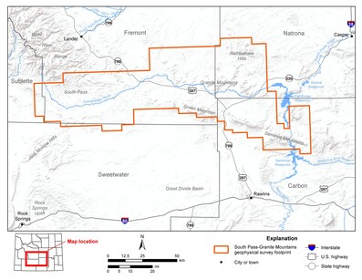
A high-resolution magnetic and radiometric survey is planned for acquisition in summer to fall 2023 in the greater South Pass-Granite Mountains region in central Wyoming. The survey is designed to optimize coverage of geologic features of greatest interest and meet complementary needs related to geologic mapping, mineral resource research, and mapping of Quaternary faults.
The effort is focused on the areas encompassing and surrounding the Oregon Trail Structural Belt, which may represent the largely obscured boundary between the Beartooth-Bighorn magmatic zone and the southern accreted terranes. This region contains several known and suspected mineral systems of high interest for their critical mineral potential, and has been the subject of abundant past and current exploration and mining.
The area covers the South Pass-Atlantic City region, Rattlesnake Hills, Granite Mountains, and the Seminoe-Ferris mountains. Additionally, the airborne survey data are expected to aid in mapping and investigations along the North and South Granite Mountains faults, the Continental Fault, and other suspected Quaternary faults. The planned survey includes magnetic and radiometric data collected from a helicopter along flight lines spaced 200 meters and a nominal terrain clearance of 100 meters.
The mineral systems of interest in the survey area include alkalic porphyry, mafic magmatic, magmatic REE, metamorphic graphite, meteoric convection, orogenic gold, porphyry Cu-Mo-Au, and volcanogenic seafloor. Potential critical mineral commodities: aluminum, antimony, arsenic, barium, beryllium, bismuth, cobalt, chromium, fluorspar, gallium, germanium, graphite, hafnium, indium, manganese, niobium, nickel, platinum group elements, rare earth elements, scandium, tantalum, tin, tungsten, vanadium, zinc, and zirconium. There is additional potential for cadmium, copper, gold, iron, lead, mercury, molybdenum, phosphorus, selenium, silver, thorium, and yttrium.
Learn more about the project in the news release.
Chris Doorn—Geologist, hired in 2023
What do you do at the WSGS? As a member of the energy and minerals team at the WSGS, part of my work involves characterizing Wyoming’s geology and mineral resources, specifically focusing on hard-rock mineral deposits. Some projects I have been involved with so far include documenting mining districts across the state, characterizing heavy mineral sandstones, and surficial geologic mapping. I am also eager to begin working in the field this summer on bedrock geologic mapping in the Great Divide Basin and on geochemical sample collection in the Medicine Bow Mountains.
What makes your job interesting? Being involved with a variety of projects at the Survey gives me the opportunity to deepen my familiarity with geology in locales across the state. These projects each involve distinct areas of study within the geosciences, and they allow me to broaden my expertise as a scientist. I enjoy cultivating my knowledge of Wyoming’s vast geologic diversity, and I look forward to visiting various parts of the state through field work and outreach events.
How does your job help Wyoming? The projects I am involved with are geared toward deepening our understanding of hard-rock mineral resources throughout Wyoming. These kinds of projects can help provide a basis for future mineral exploration, which in turn can promote economic activity in Wyoming. A primary goal of the Survey is to distribute geological information (including information on mineral resources and geologic hazards) to the public in a manner that is useful for a range of audiences.
What are some of your favorite geologic features in Wyoming and why? Although it’s a challenge to choose my favorite features from across our geologically-rich state, I have a deep appreciation for Wyoming’s mountain ranges. I am particularly interested in the Medicine Bow Mountains due to their complex geologic history. I also enjoy exploring the landscapes the Medicine Bow Mountains play host to. Another feature I appreciate is the Laramie Anorthosite Complex in the Laramie Range. These rocks are largely composed of plagioclase feldspar crystals, which can sometimes be greater than a foot in length and occasionally show stunning blue iridescence.
|
- Oregon Trail, 10 am–2 pm, June 3, Wyoming State Museum in Cheyenne—The WSGS will join several organizations at the event that celebrates the journey of 400,000 immigrants who headed west on a long, risky journey. At the WSGS table, learn about some of the geology those pioneers encountered while traveling the trail across Wyoming. Find more information about the Oregon Trail event and others at the museum here.
- Kemmerer 2023 Fossil & Mineral Expo, 9 am–6 pm, June 16–17, South Lincoln Training and Event Center in Kemmerer—Stop by the WSGS’s booth for all things Wyoming geology—rock samples, maps, freebies, maps and publications for purchase, and more. See here for more information about the event.
- Rocky Mountain Federation of Mineralogical Societies and Wyoming State Mineral and Gem Society 75th Annual Rock Show, 9 am–5 pm, July 14–16, and 9 am–4 pm, July 16, Ramkota Hotel in Casper—Several WSGS geologists will be on hand to answer questions about Wyoming geology. Stop by our booth to chat and pick up some rocks, maps, and more. Find more information here.
|