|
Geologists completed two mapping projects this summer, one of which focuses on geologic hazards while the other characterizes the study area’s mineral and energy resources.
The preliminary surficial geologic map of the east half of the Jackson Lake 30' x 60' quadrangle highlights the Quaternary geology and geologic hazards in the area east of Jackson Hole. The map completes a larger effort of 1:100,000-scale mapping in the area. The Wyoming State Geological Survey (WSGS) last year mapped the west half of the quadrangle, which also focused on a better understanding of the region’s geologic hazards and Quaternary geology.
Read more about the east half of the Jackson Lake quadrangle map in the news release.
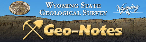
The preliminary geologic map of the Oil Mountain quadrangle, near Casper, provides updated information about the area’s stratigraphy and geologic structure, as well as potential resources of oil and gas, heavy-mineral sands, coal, uranium, bentonite, aggregate, and groundwater.
Read more about the Oil Mountain map in the news release.
The maps were completed using funding from the U.S. Geological Survey’s STATEMAP Program. The program is part of the National Cooperative Geologic Mapping Program. Geologists are in the field this summer gathering data for new maps funded through the program. Read about these projects below.
Teapot Sandstone of the Mesaverde Formation on the Oil Mountain quadrangle.
This summer, WSGS geologists are working on two 1:100,000-scale geologic maps of quadrangles in western Wyoming, as well as a 1:24,000-scale geologic map in the southern part of the state. The projects are part of the U.S. National Cooperative Geologic Mapping Program (or STATEMAP) but involve different work and objectives.
The first map will detail the surficial geology of the west half of The Ramshorn 30' x 60' quadrangle in Fremont and Park counties. The quadrangle encompasses portions of the northern Wind River Range, northwestern Wind River Basin, and southern Absaroka Range.
Generating data about landslides is a goal of the project. The Ramshorn quadrangle is in one of the most landslide-prone regions in the state; U.S. Highway 26/287 runs through the quadrangle between Dubois and Moran and has been damaged by unstable slopes in recent times.
The project will also provide detailed mapping of glacial, alluvial, and other surficial deposits that will contribute to understanding the regional Quaternary geologic history.
The Ramshorn quadrangle is one of two remaining 30' x 60' quadrangles in Wyoming without 1:00,000-scale surficial geologic mapping. This project will contribute to the WSGS’s long-term goal to map the entire state’s surficial geology at this scale.
The second mapping project underway this summer is of the Firehole Canyon 30' x 60' quadrangle in Sweetwater County, Wyoming; Daggett County, Utah; and Moffat County, Colorado. This map will be a compilation of the quadrangle’s bedrock geology. The project requires compiling previously published maps and converting more detailed mapping to a 1:100,000 scale.
The map will provide geologic data relevant to the economic resources within the southern Greater Green River Basin.
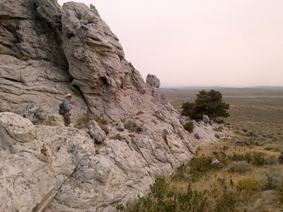
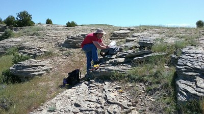
Geologists are also mapping the Phantom Lake 7.5' quadrangle in Carbon County. The mapping area is on the western flank of the Medicine Bow Mountains, about 17 miles southeast of Saratoga. This project continues the WSGS’s larger effort to map the mining districts in the Medicine Bow Mountains and will focus on documenting mineralization related to trends in regional structure and lithology.
Extensive geochronology and geochemical analysis of units within the map area will assist in identifying mineralization and potential deposits of critical and economic minerals and better establish age relationships between the Precambrian units. The final product will compile, refine, and contribute to previous mapping efforts in the area and will be published as a map series.
The three maps, once published, will be among more than 150 maps the WSGS has produced in the nearly three decades of involvement with the STATEMAP program.
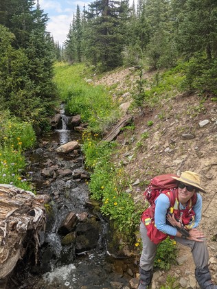
WSGS geologist Kelsey Kehoe maps the Phantom Lake quadrangle.
A series recognizing staff and their contributions
Jim Rodgers—Geologic Support, 16.5 years
What do you do at the WSGS? I support staff geologists on a wide range of projects. This might include data collection, software support, report layout, digitizing maps and well logs, and preparing figures for reports.
What makes your job interesting? The thing that makes my job interesting is that I get to work on different types of projects with different geologists. One week I might work on an oil and gas project; the next week I am working with the geohydrologist on a water project. I am always learning something new and interesting about Wyoming’s geology.
What are some of your favorite geologic features in Wyoming and why? I would have to say areas in southwest Wyoming. This includes the Killpecker sand dunes of the Red Desert and the Flaming Gorge area. I grew up camping and fishing in these areas with my family and fell in love with the geology of the area at a young age.
|