|
The first Wyoming State Geological survey (WSGS) publication released in 2022 was an investigation into the geochemistry of samples retrieved from the Kemmerer coal field in western Wyoming. Specifically, the team of geoscientists assessed the potential of many critical and economic elements in the coal and its associated rocks.
Open File Report 2022-1, Trace Element Geochemistry of Coal Deposits in the Adaville and Frontier Formations, Kemmerer Coal Field, Wyoming, is part of a statewide investigation into potential occurrences of critical and economic minerals in Wyoming. Critical minerals are elements or mineral commodities that are essential for today’s economy but vulnerable to supply chain disruptions. Coal and associated rocks can contain critical minerals.
This study considers the geochemical data from coal and associated strata from the two major coal-bearing geologic units in the Kemmerer area, the Adaville and Frontier formations.
“We included as many critical minerals as we could analyze in an efficient and economic manner, and within the constraints of the preparation and analytical methods available,” says lead author, Kelsey Kehoe. Analyses were conducted in collaboration with the Aqueous Geochemistry Laboratory at the University of Wyoming’s Department of Geology and Geophysics.
The study found most beds showed similar and predictable distribution patterns for elements measured, with a few anomalous samples, suggesting the need for additional studies.
The WSGS has several additional investigations underway that examine critical mineral potential in Wyoming. One project is on the heavy-mineral sandstones found throughout the state. Geologists are also continuing their study of mineralization in the Medicine Bow and Laramie mountains. And this year, the agency will work toward gathering data on helium resources in the state, updating the last publication released in the 1990s.
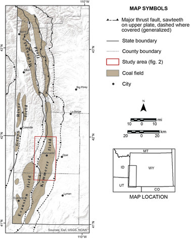
Map of western Wyoming (figure 1 in the report), showing coal fields within the Hams Fork coal
region, the extent of this study area, and the major faults associated with the Overthrust
belt.
The Powder River Basin in northeast Wyoming produced more than 6.1 trillion cubic feet of coalbed natural gas between 2001 and 2019. During the same timeframe, nearly one million acre-feet of groundwater from coal seams in the lower Tertiary aquifer system were also produced in the basin. Many of the basin’s 14,000 domestic, municipal, and agricultural wells utilize this system.
Since 2019, coalbed natural gas production has dropped significantly. WSGS Report of Investigations 78—Groundwater Level Recovery in the Sandstones of the Lower Tertiary Aquifer System of the Powder River Basin, Wyoming—examines how groundwater levels in sandstone aquifers within the Wasatch and Fort Union formations have responded to declining coalbed natural gas and water production from nearby wells.
WSGS hydrologist, Karl Taboga, says the study analyzed groundwater level data collected by the Bureau of Land Management over the last three decades from more than 90 coal seam and sandstone wells at 39 monitoring sites. His investigation showed groundwater levels have declined by more than 100 feet in some deep sandstone aquifers that were more than 600 feet below the surface and separated from a producing coal seam by less than 200 feet. There were smaller declines in shallower sandstones that were more than 200 feet from a developed coal seam.
“Changes in coalbed natural gas production and produced water provide a unique opportunity to study long-term groundwater changes,” Dr. Erin Campbell, State Geologist and Director of the WSGS, said in a news release announcing the report’s publication. “Understanding how subsurface systems relate to groundwater recovery allow us to best plan future development.”
In a unique collaboration with the U.S. Geological Survey (USGS) and multiple universities over the course of several decades, the WSGS published bedrock geologic maps of Poe Mountain and Guide Rock 1:24,000 scale quadrangles in the Laramie Mountains in southeast Wyoming.
Coauthor Dr. B. Ronald Frost, Emeritus professor at the University of Wyoming Department of Geology and Geophysics, said the maps were 30 years in the making. Originating at the USGS, the maps were delayed for many years after the death of fellow author, Dr. George Snyder. Frost approached the WSGS with the maps, and the agency agreed to publish them. Students from the UW Geology and Geophysics Department, and Dr. Donald H. Lindsley and students from the Department of Geosciences at Stony Brook University in New York also contributed to the maps.
The maps contribute significantly to our understanding of the geology of the central part of the Laramie Mountains. The quadrangles straddle the Albany-Platte county border and host the 1.4-billion-year-old Laramie Anorthosite Complex, which contains many groups of igneous rocks. This includes the Poe Mountain anorthosite.
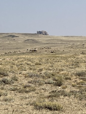
Guide Rock on the Guide Rock quadrangle.
In continuing its effort of interpreting Wyoming’s complex geology and sharing it with the public, the WSGS released nearly a dozen new publications in 2021. Half of the publications are geologic maps of quadrangles in Sweetwater, Albany, Laramie, Platte, and Teton counties.
The WSGS released two reports last year—one examining the mineralogy and geochemistry of a heavy-mineral deposit in southwestern Wyoming, the other establishing a baseline dataset for the stratigraphy and geometry of potential unconventional reservoirs in the Greater Green River Basin.
Two information pamphlets about Hot Springs and Boysen state parks were released, wrapping up a series that highlighted geology in Wyoming’s state parks.
Geoscientists also updated the interactive Oil and Gas Map of Wyoming in 2021. The map is updated every year with the latest data. It is free to use and readily accessible with any up-to-date web browser.
Reports:
Maps:
- Preliminary Geologic Map of the Richards Gap Quadrangle, Sweetwater County, Wyoming, and Daggett County, Utah
- Preliminary Geologic Map of the Goat Mountain Quadrangle, Albany and Laramie counties, Wyoming
- Preliminary Geologic Map of the West Half of the Jackson Lake 30' x 60' quadrangle, Teton County, Wyoming
- Preliminary Geologic Map of the Rock River 30' x 60' quadrangle, Albany, Platte, and Laramie counties, Wyoming
- Geologic Map of the Poe Mountain Quadrangle, Albany and Platte counties, Wyoming
- Geologic Map of the Guide Rock Quadrangle, Albany County, Wyoming
State park information pamphlets:
Publications can be downloaded for free by following the above links. Some are available as hard copies, call (307) 766-2286 to inquire.
|