|
Wyoming State Geological Survey (WSGS) geologists are mapping the 7.5' King Mountain and Ragged Top Mountain quadrangles in the Laramie Range in southeast Wyoming. The two 1:24,000-scale geologic bedrock maps are part of the Earth Mapping Resources Initiative (Earth MRI), a U.S. Geological Survey-funded program aimed at improving the national geologic framework. The multi-phase initiative works with state geological surveys to produce mapping, geochemical surveys, and geophysical studies of areas with potential for undiscovered critical mineral resources.
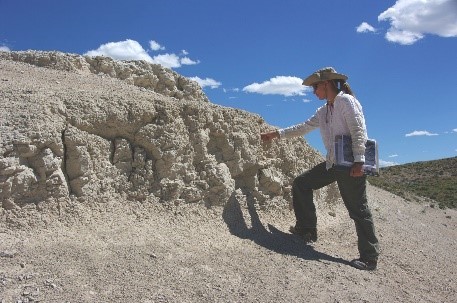
“Our project focuses on developing an understanding of the geology of the central part of the Laramie Range, where there are numerous overlapping igneous intrusions and metamorphic provinces that have the possibility to host critical minerals,” says WSGS geologist Patty Webber.
The Laramie Mountains generally trend north-south and sit between Laramie, Cheyenne, and Casper. The two quadrangles are found in the south-central portion of the mountains, northeast of Laramie.
In addition to creating the two maps, the project will produce an accompanying report and a database of geochemical results, which the USGS will release as part of the greater Earth MRI nationwide project.
The maps are also part of the larger WSGS goal to better understand the geology of the Laramie Range. The WSGS will soon publish two STATEMAP projects adjacent to the Earth MRI maps—the Goat Mountain 1:24,000-scale and Rock River 1:100,0000-scale bedrock maps.
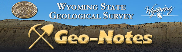
Geologist Patty Webber maps the Ragged Top Mountain quadrangle in southeastern Wyoming. The fins in the distance are folded up along the edge of the Horse Creek Thrust fault. The rocks exposed on the west side (facing viewer) are mostly Permian Casper and Fountain formations.
The WSGS published a new oil and natural gas report about Wyoming’s Greater Green River Basin’s subsurface geology. The study establishes a baseline dataset for the stratigraphy and geometry of potential unconventional reservoirs, such as the Lewis Shale, Baxter-Hilliard shales, Niobrara Formation, Mowry Shale, and Phosphoria Formation.
The Greater Green River Basin (GGRB) in southwestern Wyoming is an important oil and natural gas production region in the state. In 2019, 62 percent of the natural gas and 13 percent of the oil in Wyoming came from GGRB reservoirs.
Oil and gas production in the basin has traditionally been from conventional, high-porosity reservoirs within well-defined traps. However, developments in hydraulic fracturing and horizontal drilling have shifted the focus of exploration in Wyoming toward geographically extensive, low-porosity and permeability unconventional reservoirs.
For this study, the depths to formations, or “formation tops,” in more than 2,650 geophysical well logs were interpreted. The formation tops were used to define type logs for several subregions of the GGRB, generate contour maps of formation structure and thickness for key stratigraphic intervals, and populate the WSGS’s spatial database of subsurface oil and gas geology. The database is available on the WSGS Interactive Oil and Gas Map of Wyoming.
For more information about the study, see the news release.
Earthquakes occur nearly every day in Wyoming. Although most happen in the western part of the state, earthquakes have been felt in every county.
While most occur in remote areas, shaking from a distant event can cause damage locally. For this reason, it is important to be prepared in the event of an earthquake.
Using funding provided by the Federal Emergency Management Agency’s (FEMA) National Earthquake Hazards Reduction Program, the WSGS recently provided headlamps and power banks to county emergency coordinators across Wyoming to help them inform residents about earthquake hazards.
Along with other emergency supplies—for example, non-perishable food, water, and a first aid kit—headlamps and power banks can be great tools to have as part of a disaster supplies kit in the event of an emergency such as an earthquake.
A second goal of the campaign is to promote public participation in the 2021 Great Wyoming ShakeOut Earthquake Drill, which encourages residents to practice, “Drop, Cover, and Hold On” during an earthquake. Last year, more than 8,000 Wyoming residents participated in the drill, and the WSGS is hoping to increase that number for the Oct. 21 event. Anyone can participate, free of charge, including individuals, schools, and business. To register, please visit the ShakeOut website.
A portion of the same FEMA grant allowed the WSGS to provide emergency toolkits to counties with the highest participation in the 2020 ShakeOut. The counties awarded toolkits were Converse, Fremont, Uinta, Laramie, Big Horn, Lincoln, Sweetwater, Natrona, Albany, and Hot Springs.
Using funding provided by FEMA's National Earthquake Hazards Reduction Program, the WSGS recently provided headlamps and power banks to county emergency coordinators across Wyoming to promote public participation in the 2021 Great Wyoming ShakeOut Earthquake Drill. Along with other emergency supplies, headlamps and power banks are great tools to have in a disaster supplies kit in the event of an emergency such as an earthquake.
With summer right around the corner, so is the opportunity for road trips. Wyoming is a great place for car adventures because of the geology to see along the way.
The Survey’s Visit Wyoming’s Geology website is an excellent resource for ideas of what to see while on your journey. The map provides geologic information about some of Wyoming’s most popular must-sees: Old Faithful, Grand Teton, Fossil Butte, Sinks Canyon, the hot springs in Thermopolis, Hell’s Half Acre, Vedauwoo, and Devils Tower. There are other suggestions for exploration noted as well, including various unique geologic features, museums, state parks, and more.
Need even more ideas? Check out the ABCs Tour of Geologic Wonders in Wyoming page.
|