The U.S. Geological Survey started the Earth Mapping Resources Initiative, otherwise known as Earth MRI, to better understand the national availability and distribution of critical minerals. Critical mineral commodities are non-fuel materials essential to U.S. economic and national security, serve essential functions in manufacturing, and have supply chains that are vulnerable to disruption. In fact, the United States is 100 percent dependent on imports for 21 critical mineral commodities and at least 50 percent dependent on imports for 28 additional commodities. The Earth MRI program utilizes cost-shared cooperative agreements between the U.S. Geological Survey and state surveys to conduct new geologic mapping and collect new geophysical data.
The Wyoming State Geological Survey (WSGS) is participating in the Earth MRI program through a study of the central part of the Laramie Mountains in southeast Wyoming. The emphasis of the project is mapping the King Mountain and Ragged Top Mountain 7.5-minute quadrangles in Albany and Laramie counties. These quadrangles are part of the larger central Laramie Range study area.
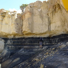
The Laramie Range contains known but poorly understood rare earth element-enriched alkalic plutons, two anorthosite complexes, a greenstone belt, and a large mafic dike swarm. The anorthosite complexes cumulatively have potential for base- and precious-metal deposits (Cu, Ni, Au, Ag) as well as critical mineral resources (Ti, V, W, Cr, and REEs). Metavolcanic rocks of the Elmers Rock Greenstone Belt are a potential source of Ni, Cr, and Mo. Additionally, several known occurrences of graphite fall within the focus area, including the Rabbit Creek graphitic schist deposit in Platte County near the northernmost part of the study area.
This two-year project will focus primarily on geologic mapping and geochemical analyses, cumulating in the publication of two maps and a geodatabase of geochemical results.
This is also a collaborative project with several members of the University of Wyoming’s Department of Geology and Geophysics: Dr. Ron Frost, emeritus professor, who mapped much of the Laramie Range over the past several decades; Dr. Simone Runyon, assistant professor and economic geologist; and Janet Dewey, associate research scientist and analytical geochemist.
|
 |
The WSGS welcomed a new staff member to the team this summer. James Amato is the agency’s new geospatial technical principal and map editor. He replaces Suzanne Luhr, who retired from the position in May.
Amato is a Wisconsin native and received his bachelor’s and master’s degrees in geology from the University of Wisconsin-Milwaukee with an emphasis in sedimentology, glacial geomorphology, and geophysics. At the WSGS, he serves as the agency’s primary point of contact for geospatial data and technologies. He also provides end-user support in project development, analysis, and outreach, and edits geological maps and databases for accuracy, aesthetics, and standards.
“I look forward to having the opportunity to study the geology of Wyoming and how it applies to the state’s mineral and energy resources, in addition to bringing public awareness to the state’s geologic hazards through data and visualization,” Amato says.
Hiking is what drew Amato to a career in geology. While pursuing his degree, he stumbled upon the application of GIS, which eventually led him to complete a professional certificate during his graduate studies.
“The idea of assimilating the natural world using geospatial technology intrigues me,” he says.
Prior to coming on board at the WSGS, Amato worked for the geology department at the University of Wisconsin-Oshkosh as an instrumentation specialist. He also co-instructed the school’s geology field camp in Utah and co-led other interim field courses to Hawaii, Bermuda, and the Black Hills.
Internships with the U.S. Geological Survey in 2016 and Wisconsin Geological and Natural History Survey in 2017 sparked his interest in working for a state or federal agency.
“I wanted to work at an agency where I could implement my technical skills of GIS in conjunction with my passion for geosciences,” he explains.
Why Wyoming?
“It has everything that excites a geologist,” Amato says. “It has always been one of a handful of states in the West that has captured my attention because of its unique landscapes and vastness.”
First on the list of places to explore is the Snowy Range and Laramie’s other surrounding areas.
“I love alpine hiking and am very excited to have the Medicine Bow Mountains in my backyard,” he says. “I can’t wait to get back to the Tetons and also the Flaming Gorge area.”
Groundwater quality varies greatly throughout Wyoming’s basins, which serve as home to most of the state’s population and economic activity. One measurement of water quality is salinity—the amount of dissolved material that remains as residue after the liquid portion of a water sample evaporates.
The WSGS investigated groundwater salinity at a statewide level and found that naturally occurring groundwater salinity varies widely within individual geologic formations, at different depths, and throughout the state. The results from the study can be found in Open File Report 2020-6, Groundwater Salinity in Wyoming.
The project examined thousands of water quality analyses from the U.S. Geological Survey and Wyoming Oil and Gas Conservation Commission. The publication includes an explanation of groundwater salinity and maps of water quality by salinity level throughout Wyoming.
The report is the latest in an ongoing series about salinity in Wyoming. Previous reports examined the salinity of groundwater in the Powder River Basin and Denver-Julesburg Basin. Geoscientists are currently working on a report about groundwater salinity in the Greater Green River Basin scheduled to be released this year.
The WSGS released five geologic maps of western Wyoming this spring.
Geologists mapped the Earnest Butte, Lion Bluffs, and South Baxter quadrangles, all on the southern end of the Rock Springs Uplift in Sweetwater County. The new maps provide key information on the timing of deformation of the uplift and insights into the mineralization history of the entire region.
The projects incorporated a range of analytical data collected from the study areas, including new detrital-zircon geochronology, geochemistry of whole rock and stream-sediment samples, and palynological as well as source-rock analyses.
All three maps will contribute to the Firehole Canyon 1:100,000-scale bedrock geology map the WSGS is working toward completing.
The Lincoln County (Blind Bull Creek and Pickle Pass quadrangles) projects focused on mapping of the Greys River fault extent. Geologists also investigated and mapped landslides in the area.
Other outcomes of the work included the mapping of previously undifferentiated Pinedale and Bull Lake glacial deposits and fluvial terraces along the Greys River.
The mapping projects are part of the STATEMAP program, which is a cooperative agreement with the U.S. Geological Survey’s National Cooperative Geologic Mapping Program.
Geologists are currently in the field gathering data for the next set of STATEMAP projects, which will be published in 2021. Quadrangles being mapped are: Richards Gap in Sweetwater County, Jackson Lake in Teton County, Goat Mountain in Albany and Laramie counties, and Rock River in Albany, Laramie, and Platte counties.
|
Yellowstone National Park is perhaps the most famous attraction in Wyoming. The world’s first national park, Yellowstone offers distinctive geology that can’t be found anywhere else.
The WSGS developed a new interactive map that offers an opportunity to learn about the park’s geology. Since its launching in May, there have been more than 7,700 views of the Geology of Yellowstone Map. Scientists have found the new platform valuable in that it offers a single interface to view multiple geologic maps and datasets. General public users have expressed excitement about live data, such as webcams.
“We’re pleased with the early feedback we’ve received on the map,” says WSGS geologist James Mauch. “Our goal was to compile the wealth of geospatial data that’s been published on Yellowstone into a single interactive map that can be used by both researchers and the general public. We hope that it becomes a go-to resource for digital exploration of Yellowstone’s geology, and we look forward to incorporating additional data in future updates to the map.”
The online map is a compilation of publicly available geospatial data from the Yellowstone Volcano Observatory (YVO) partners and external sources. The WSGS is a consortium member of the YVO, which is composed of state and federal agencies and universities that provide timely monitoring and hazard assessment, contribute scientific understanding, and disseminate information to the public on the Yellowstone volcanic system.
Map features
Users can interactively pan and zoom to areas of interest on the map, search for specific locations, and turn layers on and off. Clicking on a feature leads to a pop-up window with more information, which can also be accessed in each layer’s attribute table. Key features of the map are the Layer Explanation and Data Sources menus, which provide users with links to the original data source for each layer.
The map includes several layers of bedrock and surficial geologic maps published by the U.S. Geological Survey and National Park Service. Users will also find layers containing information on Yellowstone’s geology, thermal features, hydrography, active monitoring programs, geomorphology and geologic hazards, and basic geography.
The WSGS plans to make periodic updates and additions to the map as new studies are published, and new information is collected through data monitoring. Mauch says he is planning for the next update to occur in the fall.
A new WSGS Open File Report published this summer is a release of geochemical data from a reanalysis of archived stream-sediment samples originally collected under a 1970s federal uranium exploration program. The new data will help to establish modern baseline geochemistry for future studies of mineral systems and deposits across Wyoming.
The uninterpreted “raw” data are available as received from the laboratory, providing geologists and the mineral industry with the opportunity to use the data for research and exploration purposes.
The geochemical results are provided as Excel spreadsheets that accompany a short report detailing the sampling methodology, available as a free download from the WSGS website.
Learn more about the project in the news release.
The Rocky Mountain Federation of Mineralogical Societies and Wyoming State Gem & Mineral Society presented an honorary award to retired WSGS geologist Wayne Sutherland during the annual Wyoming Gem & Mineral Show in June in Marbleton. The plaque honors Wayne for his “distinguished achievement in the field of earth sciences.”
At the time of his December 2019 retirement, Wayne held the gemstones, metals, and economic geologist position at the WSGS. His career as a geologist spanned more than 40 years for both private companies and government agencies.
|