
NEWS RELEASE: Wyoming Geological Survey Publishes New Geologic Maps
Wyoming State Geological Survey sent this bulletin at 05/13/2020 09:51 AM MDT
May 13, 2020
******FOR IMMEDIATE RELEASE******
Media Contact:
Christina George
(307) 766-2286 x231
christina.george@wyo.gov
WSGS Publishes New Geologic Maps
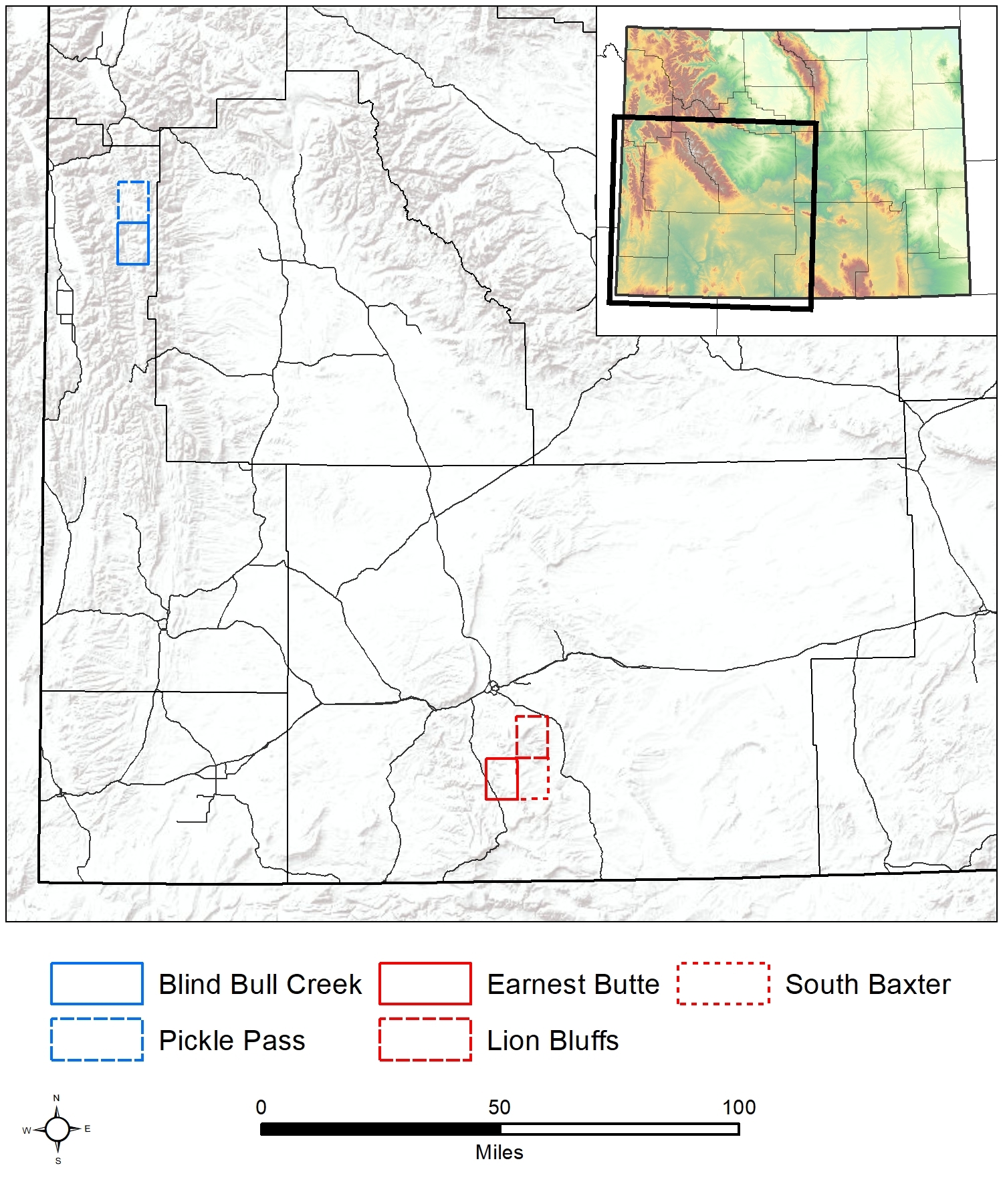
The Wyoming State Geological Survey (WSGS) released five new geological maps of areas in southwestern and northwestern Wyoming. The agency published the 1:24,000-scale maps through its STATEMAP program.
Three are bedrock maps of quadrangles in Sweetwater County:
Two are surficial maps of quadrangles in Lincoln County (combined in a single publication):
Maps, including accompanying technical reports, are available as free downloads and as hard copies for purchase.
The STATEMAP program is a cooperative agreement with the U.S. Geological Survey’s National Cooperative Geologic Mapping Program. The WSGS has produced more than 100 maps during the more than 30 years it has been a part of this program.
“Participation in the STATEMAP program allows us to greatly expand our mapping coverage of Wyoming,” says Dr. Erin Campbell, WSGS director and state geologist. “STATEMAP’s emphasis on resources and natural hazards complements WSGS mapping priorities of mineral and energy resources, hydrogeology, and geologic hazards.”
Sweetwater County Mapping
The three Sweetwater County maps are on the southern end of the Rock Springs Uplift, a large folded and faulted structure with a complex array of geology. The new mapping provides key information on the timing of deformation of the Rock Springs Uplift, as well as insights into the mineralization history of the entire region.
“When you look at all three of the maps together, they illustrate how structurally complex the southern Rock Springs Uplift is,” says geologist Kelsey Kehoe.
Kehoe was the lead investigator on the mapping of the Lion Bluffs quadrangle on the south-central portion of the Rock Springs Uplift.
“One of the most interesting takeaways from this project was the degree and extent of alteration across the quadrangle. It wasn’t just confined to Aspen Mountain, which has historically documented mineralization,” Kehoe says. “We suspect that the alteration is due to the interaction of a low-sulfidation epithermal system with thick Cretaceous marine deposits, like the Baxter Shale.”
In mapping the South Baxter quadrangle, along the southeastern flank of the Rock Springs Uplift, geologist Patty Webber says she learned that a lot of work remains to better understand the dynamics of deformation and alteration in the southern end of the uplift.
“There is significantly more faulting and deformation than is apparent from the surface; this is in part due to the syn-depositional nature of the Upper Cretaceous to Eocene units found in the Rock Springs Uplift, which were eroding and depositing as the uplift developed,” Webber says.
The Earnest Butte quadrangle, on the southwestern flank of the Rock Springs Uplift, is full of interesting geology, says geologist Dr. Ranie Lynds.
“For example, the unconformity between the Upper Cretaceous Almond Formation and the Paleocene Fort Union Formation represents about 8 million years of ‘missing’ time that was removed as strata were eroded from the flanks of the rising Rock Springs Uplift,” she says.
Lynds says geologists on this project revised the axis of the Rock Springs Uplift to lie further west of where it had previously been drawn on smaller-scale maps.
The mapping projects incorporated a range of analytical data collected from the study areas, including new detrital zircon geochronology, geochemistry of whole rock and stream sediment samples, palynological analyses, and source rock data.
All three new maps will contribute to the Firehole Canyon 1:100,000-scale bedrock geology map the WSGS is working toward completing in the coming year.
Lincoln County Mapping
A primary purpose of this project was to refine and lengthen the surface mapping of the extent of the Greys River fault, which bounds the west side of the Wyoming Range. The fault extends roughly 65 kilometers (40 miles) from the headwaters of the Greys River north to its newly recognized intersection with the Little Greys River. Geologists were able to extend tracing of the fault by more than 10 kilometers (6 miles).
“The purpose of this mapping project was to revisit prior mapping that identified a suspected unrecognized portion of the Greys River fault,” says geologist Seth Wittke. “With additional study, this new information will help scientists better understand the seismic risk in the area.”
In addition, since the area is prone to landslides, geologists wanted to investigate and map landslides in the area. At least two significant landslides—Blind Bull and Porcupine Creek—occurred in the area over the past five years, damaging roads and causing economic losses to nearby communities.
Other outcomes of the project include mapping of previously undifferentiated Pinedale and Bull Lake glacial deposits and fluvial terraces along the Greys River. In addition, mapping and detrital zircon analysis of an undated pediment surface was completed.
The results of the study may have important implications for regional seismic hazard modeling, protection of infrastructure in the Greys River valley and surrounding drainages from landslide hazards, and understanding the post-orogenic landscape evolution in the Wyoming-Utah-Idaho thrust belt.
Geologists will soon begin work on the next set of STATEMAP projects of the following quadrangles: Richards Gap in Sweetwater County, Jackson Lake in Teton County, Goat Mountain in Albany and Laramie counties, and Rock River in Albany, Laramie, and Platte counties. The four maps will be released in summer 2021.

|
Interpreting the past ~ providing for the future Email: wsgs-info@wyo.gov |
| STAY CONNECTED: | |||||||
|
|||||||
SUBSCRIBER SERVICES:
Manage Subscriptions | Unsubscribe All | Subscriber Help