|
Wyoming State Geological Survey (WSGS) geologists are wrapping up this year’s STATEMAP projects in southwestern and western Wyoming, and gearing up to begin work on four more maps. Work underway involves bedrock geology maps of the Earnest Butte, Lion Bluffs, and South Baxter quadrangles in Sweetwater County, and surficial geology maps of the Blind Bull Creek and Pickle Pass quadrangles in the Little Greys River area. These five maps, all at 1:24,000 scale, are scheduled for release in early summer.
The next set of maps are of the Richards Gap quadrangle in Sweetwater County, Jackson Lake quadrangle in west-central Teton County, Goat Mountain quadrangle in east-central Albany and west-central Laramie counties, and the Rock River quadrangle in Albany, Laramie, and Platte counties. All four maps will be released in summer 2021.
The Richards Gap quadrangle lies within the southeastern portion of the Firehole Canyon 1:100,000-scale quadrangle and is part of a larger ongoing mapping effort of that area. The Richards Gap bedrock map will focus on stratigraphic, sedimentologic, geochemical, and structural analysis of the Upper Cretaceous, Paleocene, Eocene, and overlying Oligocene strata.Geologists hope to gain a better understanding of potential energy and mineral resources in the region. Heavy mineral placers have been reported from the Rock Springs Formation in the Richards Gap area, and preliminary analyses indicate they contain elevated levels of rare earth elements and are rich in iron and titanium.
The Jackson Lake quadrangle encompasses the northwestern portion of the Gros Ventre and Wind River ranges, the Teton Range, and Jackson Hole. The 1:100,000-scale surficial map will highlight geologic hazards such as landslides, providing landslide data along important highway corridors susceptible to slope instability. Additionally, the map will investigate Quaternary faults, contributing to the understanding of relationships between active tectonics, surface faulting, and regional paleoseismicity.
The Goat Mountain quadrangle is within the Laramie Mountains and along the western flank of the Denver Basin. The goal of the project is to define the mineralogy, petrology, geochronology, and geochemistry of the Laramie Anorthosite Complex and its association with the Cheyenne belt. The quadrangle will be mapped in collaboration with Dr. Ron Frost at the University of Wyoming, who has conducted a significant amount of preliminary mapping in the Laramie Anorthosite Complex.This new regional mapping and field investigation in the Goat Mountain quadrangle will contribute to several other WSGS mapping initiatives, including the Rock River 1:100,000-scale bedrock geologic map and a 1:62,500-scale bedrock geologic map of the Laramie Anorthosite Complex.
The Rock River 1:100,000-scale quadrangle is north of Laramie, and encompasses portions of the Laramie valley, southern Laramie Mountains, and western Denver Basin. The integrated surficial and bedrock geologic map is a compilation project. This means geologists will compile existing geologic mapping and generate new mapping where needed within the quadrangle. The project will complete another important map at the 1:100,000 scale, a useful scale for regional geologic understanding.
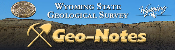
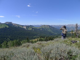
A long wet spring made last summer's field area greener than expected. WSGS geologist Patty Webber takes in the sights of a green valley, across which basal sandstones of the Cretaceous Blair Formation crop out.
A geologic map of the Chugwater 1:100,000-scale quadrangle is now available. This area covers the central portion of the Denver Basin in southeastern Wyoming and a small part of Nebraska. The new map is a compilation project, utilizing existing mapping, aerial imagery, and field checking to provide a spatial tool to better understand the geology of the study area at a more detailed scale and with consistent unit delineation.
The new map—Preliminary Geologic Map of the Chugwater 30'x60' Quadrangle, Goshen, Platte, and Laramie Counties, Wyoming, and Scotts Bluffs and Banner Counties, Nebraska—shows the extent of various bedrock formations and Quaternary deposits at the surface in the area. The primary geologic units are of Pliocene, Miocene, Oligocene, and Upper Cretaceous age, and include the Ogallala, Arikaree, White River, and Lance formations.
The map includes an age correlation of geologic units, a description of each of the units, a list and index map of references utilized, and a map of currently published 1:100,000-scale maps available for Wyoming.
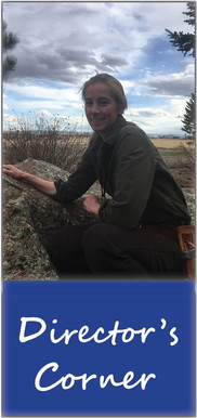
The WSGS is working to complete map coverage across the state at the 1:100,000 scale. “With this map, we will have achieved 60 percent basement map coverage of the state at this scale,” says WSGS Director, Dr. Erin Campbell.
The Chugwater quadrangle map is available for sale as a hardcopy and as a free download. Both options are available from the WSGS sales site.
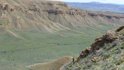
Bear Creek flows through a narrow valley south of Chugwater, Wyoming, and Diamond Flats for more than 20 miles. This valley has distinct chalky white bluffs of Brule member of the White River Formation on both sides.
The WSGS continues to release information pamphlets in its popular series about the geology in Wyoming state parks, with the latest publications focusing on Glendo and Buffalo Bill parks. Other pamphlets available are Curt Gowdy, Seminoe, Guernsey, Keyhole, Bear River, and Edness K. Wilkins.
Glendo State Park is in eastern Wyoming. The park offers geology representing more than 300 million years of Earth history that includes inland seas, rising mountains, and distant volcanic activity. The park’s hydrogeology includes the High Plains Aquifer system, which is the largest aquifer system in the country.
Buffalo Bill State Park is in the northwestern part of the state. It is home to the Great Unconformity, which marks a more than a 2-billion-year gap in the geologic record. There is also a dormant volcanic field and the world’s largest-known ancient landslide in the area. Buffalo Bill Reservoir is a prominent feature in the park.
The state park information pamphlets are free, and are available as downloads from the WSGS’s sales website and at park visitor centers.
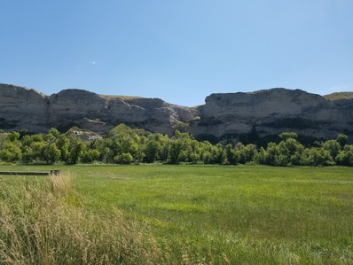
Red beds at Glendo State Park in eastern Wyoming.
The oil and gas team is working toward publishing a report on Upper Cretaceous reservoirs in the Powder River Basin (PRB). The report will use WSGS subsurface interpretations from geophysical well logs to characterize the depth to and thickness of the Upper Cretaceous source rocks and reservoirs in the basin.
“Many of these reservoirs have been important targets of oil and gas operators in the basin, and their prolific production has been an important source of funding for Wyoming’s economy,” says WSGS geologist Rachel Toner.
The publication will include type logs displaying how the WSGS interpreted each reservoir throughout the PRB. Structure contour and isochore surfaces, developed by WSGS geologist Derek Lichtner, show depth and thickness trends between the more than 2,000 wells throughout the basin. Finally, the publication will involve a publicly available database of all of the subsurface interpretations of the wells.
The next step will be to use the subsurface database as a repository for all future subsurface interpretation projects, including an upcoming study on the Greater Green River Basin led by Lichtner. Geologists will also incorporate interpretations from legacy and other recent subsurface publications.
“We hope that the upcoming publication and database will be used as a general reference or starting point for anyone interested in the overall geometry of these reservoirs,” Toner says. “Users will be able to download our actual interpretations for their own use and evaluation.”
The WSGS’s energy and mineral resources division welcomed a new geologist to the team in late 2019. Derek Lichtner says he looks forward to using his background in sedimentology and stratigraphy to further the agency’s understanding of Wyoming’s oil and gas geology.
“I also am excited to be part of a team of experienced scientists from whom I undoubtedly will learn a great deal about not only geologic practice but also its importance to the state of Wyoming,” he adds.
Lichtner is one of three new faces at the WSGS. The other two—Jill Ottman and Teresa Hansen—were hired on to the administration department in early 2020, and are responsible for office support and accounting, respectively. Both bring with them years of experience in administrative support.
Derek Lichtner
Lichtner earned a bachelor’s degree with a double major in geology and physics from Temple University in Philadelphia and a master’s degree in geology from the University of Illinois at Urbana-Champaign in Champaign, Illinois.
“In the beginning, I was drawn to geology by the promise of learning about, and among, the natural world,” Lichtner says. “Later, as my career progressed, I became fascinated by the detective work. I enjoy combining all sorts of techniques, based on all varieties of science, to interpret the subtle evidence that holds the key to millions of years of Earth history.”
His primary goal at the WSGS is to interpret oil- and gas-related data, and draft associated maps and reports. Currently, he is involved in subsurface mapping of Cretaceous and Paleocene strata in Wyoming’s Laramide basins. In the future, he plans to undertake in-depth investigations of depositional history and its relationship to well completion and production data.
Lichtner says there are two things in particular he loves about Wyoming’s landscape—its desolate beauty and the intricate stories it tells.
For example, at Polecat Bench near the town of Powell, red and purple badlands contrast with the floodplain of the Shoshone River.
“The colorful paleosols (fossil soils) contain evidence of the Paleocene-Eocene Thermal Maximum, whereas the tan sandstones that dot the hillside tell the parallel story of the then-young Rocky Mountains,” he explains. “To top it all off, the surface of Polecat Bench, 600 feet above the surrounding landscape, is made of river cobbles deposited during the Pleistocene by the ancestral Shoshone River. Evidence of a warm and humid Wyoming, the rise of mountains, and a frigid, glaciated Wyoming—all of these are in the badlands outside Powell.”
|
Jill Ottman
Ottman is responsible for assisting with the running of the office, including customer service and being backup at the front counter. She purchases supplies for the office and field, and keeps track and maintains equipment and field vehicles. Her geography background lends her the opportunity to help with proofing maps in the works. She holds a bachelor’s degree in geography from the University of Wyoming (UW), taught physical geography labs at UW, and completed an internship at the National Geographic Society.
“I am thrilled for the opportunity to have a job that feeds my love for maps and rocks,” Ottman says.
Wyoming is a geologically rich and varied state, Ottman says, and living here makes it almost impossible not to be intrigued by what you see—even on a short drive.
“I’ve always been curious about what’s under my feet, whether it’s where I live or when I am traveling,” she explains.
The Shoshone Geyser Basin in Yellowstone National Park is one of Ottman’s all-time favorite geologic features. “You have to backpack to get there, and the absence of boardwalks and signage gives you a feel for what geyser basins looked like before there were crowds of tourists,” she says.
|
Teresa Hansen
Shortly after Ottman was hired, the WSGS welcomed Hansen to the administration team. Hansen, who was previously employed with UW, says she was looking for a change when an acquaintance on campus mentioned the opening at the WSGS. She brings with her several years of experience.
“I love that I get to work with a group of kind, humorous, and understanding people,” Hansen says. “I also like the challenge to learn and complete work accurately.”
Hansen is responsible for preparing and completing financial information for the agency. She makes sure the accounting records, reports, and processes and procedures are completed in an accurate and timely manner.
Hansen, an outdoors enthusiast, says her favorite geologic features in Wyoming are the mountains and rivers.
“Both are breathtaking to me. I am in awe when we are out in these beautiful landscapes,” she explains. “The fresh air, wide open spaces, wildlife, and natural beauty are so serene to me.”
|
|