A new bedrock mapping project underway at the WSGS focuses on the Firehole Canyon 1:100,000-scale quadrangle in southwestern Wyoming. Geologist Robert Gregory is leading a team in compiling existing mapping and adding new mapping of the quadrangle to create the smaller-scale Firehole Canyon map.
“The WSGS’s long-term goal is to continue mapping at the smaller 1:100,000 scale, which provides more detailed mapping that can ultimately be used to update the larger Geologic Map of Wyoming (1:500,000 scale),” Gregory explains.
The Firehole Canyon quadrangle mostly borders Utah; a sliver of its southeastern edge touches Colorado’s border. Flaming Gorge runs through the center of the quadrangle. Eocene-age rocks are exposed throughout most of the map boundary, including the Bridger, Green River, and Wasatch formations. Farther east, older rocks, primarily Paleocene and Cretaceous in age, are exposed in the southern portion of the Rock Springs Uplift.
Geologists are currently mapping three 1:24,000-scale quadrangles within the Firehole Canyon quadrangle and are proposing similar projects in 2020. Data from this work will feed into the larger mapping project.
|
Bear River and Edness K. Wilkins state parks are the latest featured in the WSGS publication series highlighting the geology in Wyoming’s state parks. The series offers tourists an opportunity to learn about the geology they see during their visit; Wyoming residents get to learn about the geology that formed their home state.
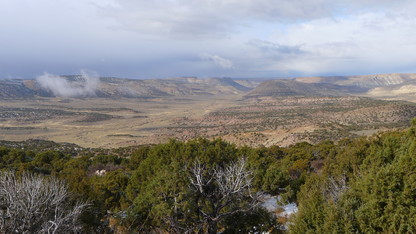
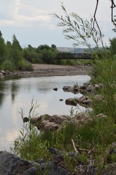
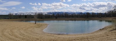
Bear River State Park (pictured at left) is outside the city of Evanston in southwestern Wyoming; Edness K. Wilkins State Park (pictured below) is near the city of Casper in the central part of the state. Both parks feature a dynamic and regionally important river (the Bear and North Platte rivers, respectively) that have helped shape the Wyoming landscape. These parks also afford views of nearby mountain ranges that were uplifted during different mountain-building episodes and that represent contrasting deformation styles.
“Bear River State Park frames a portrait of several distinct uplift and faulting periods, and Edness K. Wilkins State Park highlights the connection between rivers, their deposits, and the resources they provide,” says WSGS geologist James Mauch. “These places remind us of the dramatic changes that have occurred throughout geologic history, and that the people and landscapes of modern-day Wyoming are ultimately linked to this distant past.”
Other state park pamphlets available are Keyhole, Guernsey, Seminoe, and Curt Gowdy. Pamphlets are free and are available at the WSGS office on the University of Wyoming campus in Laramie and at park visitor centers. Pamphlets also are available for download from the WSGS website.
|
The WSGS has published an updated paper version of the Oil and Gas Map of Wyoming, offering a generalized view of current oil and natural gas activity statewide. The 1:500,000-scale map—one of the agency’s more popular publications among a diverse range of audiences—is available for purchase or as a free download.
The new map replaces the 2016 version and depicts the latest oil and gas field polygons and field attributes, such as producing reservoirs, hydrocarbon products, and whether fields are used for storage or disposal. The map also shows the state’s active and inactive oil refineries and natural gas processing plants, with daily refining and processing capacity noted for active facilities. Data about pipelines and their transport products were provided by the Wyoming Pipeline Authority.
Interesting oil- and gas-related tidbits are scattered throughout the new map as well.
Lead map author and WSGS geologist Rachel Toner said the 2019 version took a few weeks to complete instead of the months and even years it has taken for previous oil and gas maps. There are a few reasons for the shorter turnaround, she explains.
“The oil and gas data had already been created for the online map, and the base layers had been decided upon for the 2016 version, so we did not have to start from scratch,” Toner says. “We also had an internal deadline to get it done ahead of the September Rocky Mountain Section of the American Association of Petroleum Geologists conference. There was a concerted effort by staff to meet that goal, which we did.”
The WSGS maintains an interactive online version of the map, which staff update annually. See the news release for more information.
The WSGS will say farewell to one of its longtime geologists at the end of December. Gemstones, metals, and economic geologist, Wayne Sutherland, is retiring after several years with the agency.
“When I retire, I look forward to spending more time with my wife, Judy,” Sutherland says. “I also plan on a variety of travel, hobbies, and home projects. I will always connect with geology and will maintain contact with many of the people I have met during the course of my job.”
Sutherland has worked more than 40 years as a geologist for private companies and government agencies in Wyoming, Montana, and Utah. He has worked at the WSGS at various times since the 1970s and in various capacities, including part time, as a contractor, and volunteer.
“Wayne’s knowledge and enthusiasm truly will be missed at the survey,” says WSGS director, Dr. Erin Campbell. “The breadth of information he has about Wyoming geology, as well as the depth of his expertise in minerals, cannot be replaced. We wish him all the best in retirement.”
In the 1970s, his responsibilities ranged from compiling coal data to investigating caves in Wyoming. Toward the end of the 1980s, he worked with stream sediment sampling in search of kimberlites and with various metals and gemstones. In the late 1990s through mid-2000s, Sutherland held different contract positions, primarily in metals and gemstones, and in geologic mapping. After a few years as a part-time employee, he was hired full time at the WSGS.
Sutherland’s draw to geology started in childhood when he would ask his next door neighbor about what lies beneath the ground.
“As I grew up, I would pick up interesting rocks, mostly in the Medicine Bow Mountains,” he explains. “When I entered college, my first introductory geology class at the University of Wyoming got me hooked. Classes, lectures, and field trips brought to life a four-dimensional appreciation for Wyoming’s geology.”
Sutherland earned his bachelor’s degree in geology and his master’s degree in geomorphology from UW. Mentors while attending UW include Brainerd “Nip” Mears, Sam Knight, Don Boyd, Don Blackstone, Scott Smithson, Bob Houston, Ron Parker, and Ron Marrs.
Being a geologist holds numerous attractions. Sutherland says for him, it is the public outreach opportunities and the field work that he most enjoys.
“Field work, site investigations and mapping, combine physical exercise with geologic conundrums. My assistant one year figured that we had walked over 100 miles in the course of field work; good exercise in the fresh air,” he explains. “The exercise is needed to collect data and compile map elements. Interpretation of the data, in combination with its geologic/geographic elements, provides a mental picture of a particular geologic setting. Reduction of the mental picture contributes to a finished map and written report explaining the geology and mineralization. Completion of maps and investigations is satisfying.”
In the last four decades, Sutherland has been all over the map, Wyoming map that is, studying the state’s geology and geologic features. When asked to pick his favorite, he replies, “The best geological places or features in Wyoming include a variety of locations where we have just enough information to discern a geological puzzle, but not enough information to solve it without serious on-the-ground investigation.”
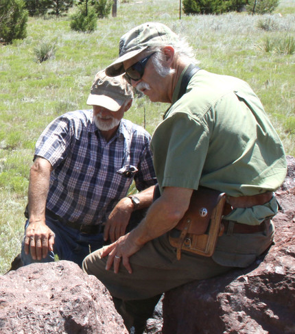 Wayne Sutherland, at right, visits with Jon Voight at the Sunrise Mine near Hartville, Wyoming, in summer 2018.
|