|
When the Wyoming State Geological Survey (WSGS) set out in 2016 to launch an online, interactive version of the popular Oil and Gas Map of Wyoming, one of the goals that inspired the project was the ability to update the map more frequently to keep up with the state’s rapidly changing oil and gas industry.
The online map is currently updated annually and the most recent update was in May. Each update redefines the spatial extent of oil and gas fields by incorporating new wells drilled in the state during the previous year. In addition to providing up-to-date information, the routine updates allow geologists to see new trends occurring in Wyoming’s oil and gas industry.
Although the 2019 version of the Interactive Oil and Gas Map of Wyoming may not look much different from the outset, a closer look highlights significant activity statewide. Last year, 599 wells were completed in the state. Of these completions, 235 are in the Jonah and Pinedale fields in Sublette County, where operators are testing the field boundaries with nearly 2-mile-long laterals. These two fields produced 38 percent of Wyoming’s 2018 natural gas.
More than 46 percent of the wells completed in 2018 were horizontal wells, with the majority producing from Upper Cretaceous-age reservoirs in Campbell, Converse, and Laramie counties. The Frontier Formation, Turner Sandstone, and Codell Sandstone continue to be operators’ primary targets in the Powder River and Denver basins. In 2018, the Frontier Formation and the Turner Sandstone accounted for 41 percent of the Powder River Basin and 23 percent of all Wyoming oil production. The Turner Sandstone was also the Powder River Basin’s highest non-coal gas-producing reservoir last year, accounting for 27 percent of all natural gas produced from the basin.
The map contains many layers, including fields, all wells from the Wyoming Oil and Gas Conservation Commission, the subset of wells used to create the fields, bottomhole locations for horizontal and directional wells, in addition to pipelines, surface and mineral management, and base layers including statewide geology.
More information can be found in the news release.
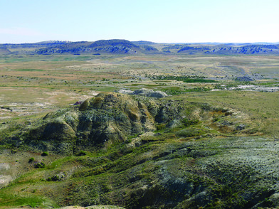
Photo caption: Subtle outcrops of the lower fine-grained member of the early Eocene Wind River Formation near Sarcophagus Butte. View is looking northeast toward the Gas Hills hogbacks.
The Gas Hills uranium mining district—Wyoming's all-time top-producing district, located in the central part of the state—is the focus of a new WSGS public information circular. The publication is available as a free download.
Uranium is a critical mineral and heavy metal used as a strategic military commodity and for nuclear power generation. The state of Wyoming produces the most uranium and hosts the largest-known uranium reserves in the United States.
Since its discovery in the 1950s, the Gas Hills district has been the top-uranium-producing district in the state. Although production ceased in the 1980s due to a weak market, significant unmined uranium reserves—upwards of 50 million pounds of uranium concentrate—remain in the district.
The new publication addresses geologic factors associated with uranium source rocks, mobilization, mineral precipitation, discovery, mining history, and future uranium-mining potential of the Gas Hills district.
More information can be found in the news release.
|
Landslides happen every year in Wyoming. Most go unnoticed because they occur in unpopulated, remote locations. In an effort to understand where landslides might occur in the future, a new WSGS study focuses on statewide susceptibility of deep-seated landslides, or landslides that involve bedrock.
The results of the investigation are accessible in two ways: a published map, available as a free download or as a hard copy for purchase, and as a new interactive layer on the online Wyoming Geologic Hazards Map.
The goal of the project is to aid in promoting awareness of landslides as a natural geologic hazard and to help focus attention on areas where landslides are not well understood.
“The results of this study are consistent with areas of the state known to have high potential for landslides, including much of northwestern Wyoming, the Wind River Mountains, and the flanks of the Bighorns,” said Seth Wittke, WSGS geologist and map co-author. “However, the results also highlight lesser-known areas of Wyoming that may be at risk for deep-seated landslides. We will focus much of our future work in these areas.”
The map and associated data are meant to be used at regional scales. The study’s results do not incorporate susceptibility to debris flows or other shallow landslides, and are not appropriate for site-specific evaluation.
More information can be found in the news release.
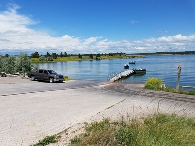
Photo caption: Keyhole State Park is the focus of the latest pamphlet in a series about geology in Wyoming state parks.
The WSGS continues adding to its series of information pamphlets about geology in Wyoming’s state parks. The latest publication focuses on Keyhole State Park in the Black Hills region in northeast Wyoming.
The park’s geology preserves the story of Wyoming’s Jurassic and Cretaceous past, a time when much of the state was under water. The pamphlet includes a geologic map and a stratigraphic chart depicting the geologic formations exposed in the park.
There is also an overview of Keyhole Reservoir. The 37,000-acre reservoir on the Belle Fourche River is the largest body of water in the northeast corner of the state.
Available information pamphlets:
Pamphlets in production will cover geology in Bear River, Edness K. Wilkins, Boysen, and Hot Springs state parks.
|
Geologists spent summer 2018 mapping the Garden Gulch and Horatio Rock quadrangles in southern Wyoming, resulting in two new 1:24,000-scale bedrock geologic maps:
The projects are continuations of previous mapping work and contribute to the understanding of the state’s complex geology. Written technical reports accompany the maps, and provide additional detail about each quadrangle’s unique geology, structure, and economics as well as geochemical and geochronological analyses.
Both maps are available for a fee at the WSGS office or as a download at no cost on the agency’s website. More about the two maps can be found in the news release, and more about the WSGS mapping program can be found on the agency's website.
|