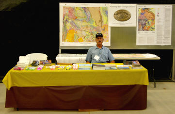
 Wyoming State Geological Survey (WSGS) staff have been abuzz about a rare fossilized tapiromorph discovered in western Wyoming that may be the first of its kind and is the largest mammal found in the Green River Formation. While fossils are common in the 50-million-year-old geologic formation, this discovery is significant because it may support a North American origin of tapirs that in modern times typically inhabit jungles and forests in South and Central America and southeastern Asia.
The rock slabs were CT scanned and X-rayed at Ivinson Memorial Hospital and Stitches Acute Care Center, both in Laramie, Wyoming, so that geologists could view and identify fossilized material encased in the rock.
The fossil was recently prepared for scientific purposes. The process was documented in a series of photos and time-lapse progression videos on the WSGS website and social media pages. Now prepared, the specimen will be housed at the WSGS and available for scientific research and for display at museums.
More about the fossil can be found in the news release.
(Photo caption: A close-up image of the tapiromorph specimen's toes. Since modern tapirs have four toes on their front feet and three on their hind feet, we can assume that this is a look at one of the specimen's front feet.)
|
The WSGS has developed an online map depicting information about the state's mines and mineral resources such as mine locations, geology, historical data, mineralogy, and chemical analyses. The Mines and Minerals Map also offers geologic interpretations, based on a variety of sources, that provide perspective on mineral commodity host rocks and geologic environment.
The map is a work in progress. It currently has information on more than 3,000 sites, and that number will continue to rise as more data is added continuously. Sites depicted on the map vary from historical and contemporary mines to prospects and sample locations. Data includes coal, aggregates, uranium, metals, and other minerals, specifically addressing analyses for the 35 mineral commodities deemed critical to U.S. economic and national security.
The Mines and Minerals Map is the fourth interactive data map launched by the WSGS in two years and similarly will be updated routinely as more information becomes available. Others are the Oil and Gas Map of Wyoming, Geochronology Map of Wyoming, and a Groundwater Atlas of Wyoming. All WSGS online data maps are free to access.
More information about the new map can be found in the news release.
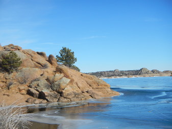 Situated in Wyoming's southeastern corner, Curt Gowdy State Park covers an area of 3,400 acres in the southern Laramie Mountains. Within the boundaries of the park lies geology too fascinating to keep a secret.
The geology of Curt Gowdy State Park is the focus of a pamphlet the WSGS published this summer as part of a new program highlighting geology of Wyoming's state parks.
The Curt Gowdy pamphlets are available at the park's visitors center, at the WSGS office on the University of Wyoming campus in Laramie, and as a free download on the WSGS website.
|
The WSGS published a pair of preliminary bedrock geologic maps of quadrangles that focus on uranium geology and mineralization of Precambrian rocks as part of its StateMap program. The 1:24,000-scale mapping projects are of the Gas Hills quadrangle in Fremont and Natrona counties and the Albany quadrangle in Albany County.
"Geologic maps are fundamental building blocks of geologic analysis,” says WSGS Director, Dr. Erin Campbell. “These two maps were created in support of studies on uranium exploration and mineralization trends within Wyoming."
Gas Hills project lead geologist Robert Gregory says the Gas Hills uranium district is one of the most important in Wyoming. With more than two dozen historic uranium mines and several developing uranium mining projects in the area, Gregory's work focuses on structure and uranium host rocks.
"Detailed mapping of the quadrangle has helped further our understanding of the relationships between the various rock units, particularly the uranium-bearing formations, and the structures that affected the deposition of uranium ore," Gregory says.
The goal of the Albany project was to produce a large-scale bedrock geologic map to determine petrologic and structural events that influenced mineralization in the southern Medicine Bow Mountains mining district.
Geological mapping is a critical focus area for the WSGS, which has participated in the StateMap program (historically CoGeomap) for more than 30 years. The mapping projects were funded through the National Cooperative Geologic Mapping Program managed by the U.S. Geological Survey.
New StateMap projects underway and scheduled for release in 2019 are of the Garden Gulch (Carbon County), Lankin Dome (Fremont and Natrona counties), and Horatio Rock (Albany and Carbon counties) quadrangles.
More information about the new maps can be found in the news release.
A new WSGS publication investigates groundwater salinity in the Power River Basin in northeastern Wyoming. The authors of the report specifically focused on groundwaters that occur at depths of 7,000 feet or less in the basin where significant oil and gas activity has taken place in recent years. Special emphasis was placed on the location of naturally occurring saline groundwaters with total dissolved solids levels greater than 5,000 parts per million that may be suited to some industrial uses, thereby conserving high-quality water for domestic, agricultural, and livestock uses.
The results of the study, according to lead investigator, WSGS hydrogeologist Karl Taboga, show that naturally occurring moderately saline groundwaters first appear in a few locations in the west-central Powder River Basin at 1,000 feet below the surface and are widely scattered throughout the entire basin at depths exceeding 5,000 feet.
The publication is the second in a series of studies examining the occurrence of industrial-grade groundwaters in Wyoming's structural basins. The first report in the series focused on the salinity of groundwaters in the Denver-Julesburg Basin in southeastern Wyoming.
To learn more about the new publication, see the news release.
WSGS geologists in recent years have carried out salinity
investigations in the Denver-Julesburg Basin of southeastern Wyoming and most
recently the Powder River Basin in the northeastern corner of the state
(see story above). A study is now underway of the
salinity in the Greater Green River Basin in southwestern Wyoming.
Salinity is one way to measure water quality, including
whether it is suited for human and livestock consumption and agricultural
usage. Also referred to as total dissolved solids, salinity is the amount of
dissolved material remaining in groundwater as residue after the liquid portion
of a water sample evaporates.
The study involves investigating the salinity of groundwater
occurring at depths of up to 7,000 feet in the basin where there has been
recent significant oil and gas activity. Hundreds of water quality analyses
from the U.S. Geological Survey and geophysical well logs from the Wyoming Oil
and Gas Conservation Commission are being examined for this study.
Read more about the Greater Green River Basin’s oil and gas
geology, past production, and future development by clikcing on the Greater Breen River tab here.
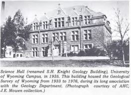 Although the geological survey's history dates back to 1877 when Wyoming was still a territory, the agency as it is today was formally established by the Wyoming Legislature in 1933.
The head of the University of Wyoming's geology department, Samuel H. Knight, was appointed State Geologist, and the agency was headquartered within the university's geology department (see photo on the right).
The WSGS is celebrating its 85th anniversary with snapshots of the agency over the decades in posts on its social media pages. Be sure to follow along on Facebook, Twitter, and Instagram.
Read about the WSGS' early years in, "A History of the Geological Survey of Wyoming."
|
Two years ago the WSGS launched a web-based interactive Wyoming Oil and Gas Map with the goal of providing a platform that would accommodate routine updates as new data are gathered. The most recent update occurred in June and highlights the fact that more than 580 oil or gas wells were completed in Wyoming last year. This is an increase from the more than 360 wells completed in 2016. Most of the oil or gas wells are in the Powder River Basin's stacked reservoirs that are Late Cretaceous in age.
The online data map displays oil and gas fields, their producing reservoirs, horizontal wells, pipelines, oil refineries, gas plants, hydrocarbon products, and well production status. It complements the WSGS' traditional Oil and Gas Map of Wyoming (updated in 2016). A major objective for launching the online map and automating data processing is to have the ability to make updates more frequently. Updates take less than a month to complete, whereas previous map updates took several months and even years.
Find out more about new data aquired during the latest update in the news release.
Alice Robison, of Laramie, participated in our Knightia fossil fish coloring contest held during the March 18 Fossil Fish Festival at the University of Wyoming Geological Museum in Laramie.
WSGS geologist Kelsey Kehoe explained how rocks are identified during the June 2 Summer Outdoor Slam event at Curt Gowdy State Park.
WSGS geologist Wayne Sutherland represented the Survey at the June 15-17 Wyoming State Gem and Mineral Show in Marbleton.
There is a great crew working at the WSGS, and now the public can learn a little bit about the team on new staff bio pages on the agency's website. To view an individual staff member's page, click on the person's name listed in the staff directory. Bios include education, experience, past and present projects, and hobbies.
Staff bio pages aren't the only changes on the WSGS website. Updates have been made to the coal, uranium, and oil and gas pages, and a new page has been created about the rare mammal fossil preparation project.
Also, new geologic sites were added to the online interactive Visit Wyoming's Geology map to highlight the many milestones reached this year such as the 175th and 150th anniversaries of the Oregon Trail and South Pass/Atlantic City, respectively.
|