|
Wyoming State Geological Survey (WSGS) Director and State
Geologist, Tom Drean, is retiring from the position this fall after six years
of service.
His departure is effective Nov. 21, at which time WSGS
minerals and resources manager, Erin Campbell, will assume the role (see story on right). The
state geologist additionally serves on the WSGS Advisory Board, Wyoming Oil and
Gas Conservation Commission, Wyoming Board of Professional Geologists, Wyoming
Consensus Revenue Estimating Group (CREG) and the Enhanced Oil Recovery
Institute Commission, at the University of Wyoming.
Drean was a former ConocoPhillips president for Iraq before Gov.
Matt Mead appointed him to replace Wallace Ulrich at the WSGS in December 2011.
Reflecting on the half dozen years leading the Survey, Drean
says he will miss the opportunity to work and interact with people from across
Wyoming on a daily basis.
“It has been a great privilege and honor to have the
opportunity to do so, and I feel very fortunate and thankful to those who have
made these six years memorable and rewarding,” Drean says.
Since coming on board at the WSGS, Drean has overseen staff
publish nearly 80 publications, including maps and reports useful to everyone
from professionals to tourists. Other successes in his tenure include
transitioning to digital platforms such as interactive maps (oil
and gas, groundwater
and geochronology) and providing publications as free
downloads.
Drean says what he appreciated and enjoyed the most about
his job was the wide variety of work and, at times, unpredictable challenges that
cropped up and faced the agency.
“Most memorable was the curiosity and joy in a child’s face
and voice when they were having a question of theirs answered about a rock,
fossil or geologic feature,” Drean adds.
He says the WSGS plays a key role in Wyoming in ways he
believes many don’t understand or fully appreciate such as the important
estimates that go into CREG and the identification, characterization and
understanding of the natural resources that are important to the state and
nation.
“The WSGS alerts the public to geologic hazards such as
landslides, earthquakes and other public safety-related phenomenon that can be
devastating to the state, communities and individuals,” he explains. “The WSGS also
gathers and shares information with industry, students, educators and the
general public that helps foster and support the ever growing geo-tourism
industry that is bringing visitors and revenue to the state.”
Drean believes the role of the WSGS in the state has
strengthened over the years, an improvement he credits to the staff.
“Their pride in Wyoming and overall desire to contribute and
make it an even better state than it already is shines through and is reflected
in their work and day-to-day contributions,” he says.
 WSGS director, Tom Drean, (pictured center, back row) is retiring from the Survey after six years in the position.
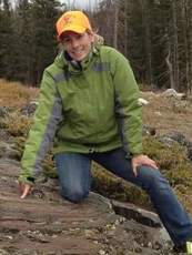
Geologists spent more than a combined
2,000 hours in the field on three mapping projects recently published under WSGS' StateMap program. Two of the maps depict bedrock geology, structure and energy
resources. The third examines surficial geology and Quaternary-age faulting. All
three are at a 1:24,000 scale.
"This has been a productive and successful field season
for the Wyoming State Geological Survey, and I am proud to say that the work
was completed on time, under budget and most important of all, safely,” says
WSGS director, Tom Drean.
The three maps are accompanied by written reports and are
available as free downloads from the WSGS sales site.
The preliminary surficial geologic map of the Muddy Gap area
in northwestern Carbon and southeastern Fremont counties comprises portions of
six 7.5' quadrangles. It also contains the Muddy Gap segment of the South
Granite Mountains fault system. Geologists found surficial deposits ranging
from bedrock outcrop to alluvium across the area.
The second map published is a bedrock geologic map of the
Fort Steele quadrangle in Carbon County. The investigation provided critical
information about the depositional history of the Mesaverde Group. A subsurface type log was created for the
area, which has oil and gas development potential, and serves as an outcrop analog
for these same reservoir rocks in the nearby subsurface.
The final map, also a bedrock geologic map in Carbon County, is the Bridger Pass quadrangle. This project includes a type log that
will be valuable for nearby energy development. Additionally, coal quality in
the Almond Formation, a locally significant coal source, was determined. Total
organic carbon was analyzed from the Niobrara Formation that will provide
information for future unconventional oil and gas resource development.
Current StateMap projects under development and scheduled for release
in spring 2018 are preliminary bedrock geologic maps (all at 1:24,000 scale) of the Gas
Hills quadrangle (Fremont and Natrona counties), Albany quadrangle (Albany
County), Foxpark quadrangle (Albany County) and Woods Landing quadrangle
(Albany County).
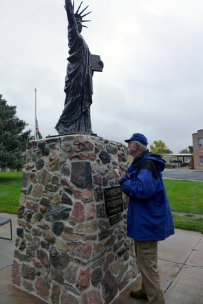 Despite the dreary October day, passersby of the miniature Statue of Liberty towering above the southwest corner of the Goshen County Courthouse grounds in Torrington, Wyoming, stop to ask the man examining the statue’s pedestal what he is doing.
The man studying the 325 rocks that gives the copper statue its base is Wayne Sutherland, the gems and minerals geologist at the Wyoming State Geological Survey (WSGS).
“The large number of rocks found in the base of the Little Sister of Liberty Statute in Torrington is impressive,” Sutherland says.
The inquirers’ wide smiles across their faces glow with pride for the statue that has stood since Nov. 11, 1950. Many point out their favorite rocks or fossils and comment on what they believe them to be.
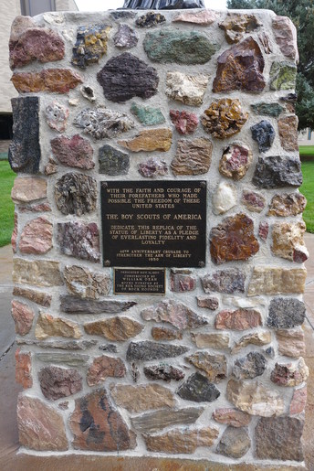
On one side of the base, rocks surround a plaque that reads, “With the faith and courage of their forefathers who made possible the freedom of these United States, the Boy Scouts of America dedicate this replica of the Statue of Liberty as a pledge of everlasting fidelity and loyalty.”
The statue is one of more than 200 replica Statues of Liberty, called Little Sisters of Liberty, the Boy Scouts of America dedicated as part of its 40th anniversary crusade to “Strengthen the Arm of Liberty.” It was post World War II and near the start of the Cold War era.
The Boy Scouts’ effort in the late 1940s and early 1950s led to copper statues erected on courthouse lawns and in city parks in 39 states. In Wyoming, statues were erected in Torrington, Cheyenne and Rawlins. Today, there are fewer than 150 remaining, says Goshen County Clerk, Cindy Kenyon.
Like many others, Torrington’s statue fell into disrepair. “Over the years, our Little Sister had suffered in the Wyoming weather. Hail had been quite unkind,” Kenyon explains.
In 2016, Kenyon and courthouse facilities manager, Tony Richard, began a project to recondition the statue and its base. The statue’s hail-damaged crown was repaired, lacquer was restored and old mortar was repointed. Lighting was added to the area as well.
After repairs were completed in summer 2017, Kenyon’s assistant deputy, Kathy Vannier, contacted the WSGS about identifying the variety of rocks and fossils in the base.
“The base consists of many local rocks and minerals, and is beautiful to see,” Kenyon says.
Communities provided pedestals for their respective Little Sisters. William Dean constructed Torrington’s statue, and the local Rex Young Society of Rock Hounds donated rocks for the base.
“The majority of the rocks collected by members of the Rex Young Society of Rock Hounds in 1950 or earlier appear to originate in the Hartville Uplift and other parts of eastern Wyoming,” Sutherland says.
Sutherland spent more than half a day taking notes and photographs, measuring rocks and testing them for hardness. He also pinpointed where some rocks originated.
The most common rock types mortared in the base include quartzites, agate/jasper/chalcedony, calcite onyx and limestone. The local limestones are often hosts for a variety of agate and jasper nodules, Sutherland explains.
Other varieties include green fuchsitic quartzite, yellowish-green to black serpentenite, pink to red granite gneiss, quartz breccias in an iron-rich matrix and some limestone accompanied by purple fluorite, which appears similar to rocks found in the Bear Lodge Mountains near Sundance, Wyoming.
“One of the most interesting rock types is a red quartz sandstone with cream-colored highlights that probably came from outcrops of the Guernsey Formation in the Hartville Uplift near Sunrise,” Sutherland says.
With repairs complete and a record of what rock types make up its base, the statue shines as a bright light in Torrington.
“The statue is a monument to the patriotism and freedom of our great nation,” Kenyon says. “She looks sound and will stand strong for many years.”
|
 |
|