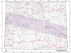
 WSGS geologists Erin Campbell and Jacob Carnes look at the Lake Owen Mafic complex during a field day at Lake Owen in southeast Wyoming.
If you stop
by the WSGS office on a summer day, chances are
some, if not all, staff geologists are away. That is because once temperatures
warm and the last snowflake flies, desks and computers in their offices are set
aside for a field notebook, GPS, compass and good hiking boots for rural
terrain.
Field work
is one of the most challenging, yet rewarding, aspects of being a WSGS
geologist.
“The best
part about field work is being able to figure out the puzzle,” says geologist
Ranie Lynds. “Those ‘aha’ moments can come when mapping, when stumbling upon a
key outcrop or when plotting or summarizing the data back in the office.”
Given
Wyoming’s long winters and unpredictable falls and springs, geologists cram their
summer months with field work, averaging 20 to 25 days. Depending on the
project, it may be a 30-minute drive to the site or several hours, resulting in
staying over in nearby towns or pitching a tent.
Regardless
of the location, the purpose is the same – investigate rocks, such as outcrops,
unconsolidated sediment, water or other geologic features.
“Field work
is an essential part of any natural science,” WSGS geologist Jacob Carnes said.
This summer,
teams of geologists are gathering data in the field to map quadrangles mainly
in the southern and central portions of the state. The work is part of Statemap
through the National Cooperative Geologic Mapping program. The primary
objective of this program is to establish the geologic framework of areas vital to the welfare of individual states.
"Sometimes
field work is the project, such as Statemap where we have a deliverable of a
map,” says Lynds. “However, most of the time field work is in addition to – but an integral part of – a project and necessary to complete the project.”
Carnes says nearly every project he has worked on at the WSGS has involved field work in
some capacity.
“For many of
the mineral investigations we have completed over the last five years, such as
rare earth elements, zeolites and phosphates, we have done field work to
identify and describe specific mineral occurrences and to collect samples. This needs
to be done before any lab analyses can be completed,” he explains. “Even
for projects that are entirely office-based for Survey staff, like the geochronology
map, we rely on field work and mapping of other geologists.”
A typical
day in the field starts by being on site at about 8 a.m.
“Generally,
we park the truck and start walking. We walk all day, measuring and describing
rocks and outcrops as we go along,” Lynds says.
Geologists,
including contractors hired for specific projects, return to their vehicle
around 4-5 p.m. after walking five to eight miles. The long days are regardless
of weather, including heat and snow. There’s also rattlesnakes to watch for,
mud to avoid and hours of hiking that don’t always end with finding out the answer
geologists are looking for.
“A lot of
time, especially early in mapping projects, can be spent in utter confusion,
which can be compounded with other factors like poor weather or physical
exhaustion,” Carnes says.
Some
projects require additional steps. For example, Carnes said this
summer’s work on the Foxpark quadrangle in southeast Wyoming has involved more
scouting of the area in their field vehicle to identify access and areas with
good outcrops. This is due to dense vegetation.
But it’s
critical to see the rocks in person.
“It is
nearly impossible to understand a formation without seeing the rocks,” Lynds
explains. “This allows the geologist to make his or her own interpretation of
the depositional environment or the reason for mineralization, etc. Without
field work, this could be blind guessing.”
Carnes
agrees.
“It allows
us to observe geologic features and relationships in their natural
environment,” he adds. “It’s impossible to fully understand any given rock
without information of its geologic context.”
Both Lynds
and Carnes say it’s impossible to note the best areas to spend field days.
“Wyoming is
a geologic wonderland. It is great pretty much anywhere,” Lynds says.
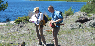
 WSGS geologist Ranie Lynds collects samples from the Mesaverde Group for detrital zircon U-Pb geochronology during recent field work in the Fort Steele quadrangle near Rawlins.
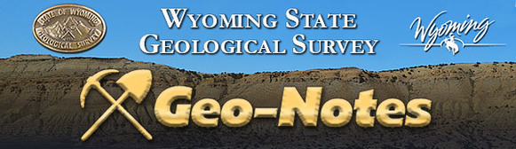
The river basins of northeastern Wyoming are among the most
important drainages in the state; they collectively contain one quarter of the
state’s surface area and much of its energy resources. The northeast river
basins include the drainages of the Little Bighorn, Tongue, Powder, Little
Powder, Belle Fourche, Little Missouri, Cheyenne and Upper Niobrara rivers.
Under contract to the Wyoming Water Development Office
(WWDO), WSGS hydrologist Karl Taboga is developing a groundwater technical memo
that defines the geographic extents of the area’s important aquifers and
describes their hydraulic and chemical properties, recharge areas and estimated
recharge rates. The project also identifies existing groundwater studies and
future groundwater development opportunities to satisfy projected agricultural,
municipal and industrial demands.
The technical memo represents an intensive collaborative
effort among water resource professionals from the WSGS, the WWDO and the USGS.
Additional contributors include the Wyoming State Engineer’s Office, the Water
Resources Data System at the University of Wyoming, the Wyoming Department of
Environmental Quality and the Wyoming Oil and Gas Conservation
Commission.
Like previous river basin studies by the WSGS, this
technical memorandum will provide the people of Wyoming with the most current and
complete compilation of groundwater information available in a format that is
understandable to water professionals and lay persons alike.
This report is scheduled to be published in 2018 and will be
available on the Wyoming Water Development Office website and through the Wyoming River Basin Plan portal
on the WSGS website.
The WSGS recently launched a geochronology map that presents Wyoming-specific data compiled from published and unpublished sources, in addition to data collected specifically for Survey projects.
The new map is free to access and is intended to be a starting point for users interested in age data related to Wyoming. Jacob Carnes led the project.
|