FEMA Announces $600 Million To Help Communities Reduce Flood Risk
Mitigation Activities Save Lives And Reduce The Cost Of Future Disasters
The Federal Emergency Management Agency (FEMA) announced a new $600 million funding opportunity for states, territories and Tribal Nations to make their communities safer from flooding.
This assistance is available through the Fiscal Year 2026 Flood Mitigation Assistance Swift Current funding opportunity. The program was specifically designed to expedite funding to states, territories, and Tribal Nations that recently experienced a severe flooding disaster. This funding is important for communities across the nation because floods are the most common and costly type of natural disaster.
FEMA’s Flood Mitigation Assistance Swift Current program funds community-led projects to reduce or eliminate the risk of repetitive flood damage to structures and buildings insured by the National Flood Insurance Program.
Application deadlines vary. States, tribes or territories must have received a federal flood-related emergency or major disaster declaration between June 1, 2025, and May 31, 2027, to be eligible for this funding cycle. For each qualifying flood event, FEMA will provide a deadline to eligible applicants.
Comprehensive information on the Flood Mitigation Assistance Swift Current funding opportunity including eligibility criteria, application deadlines, cost-share and other essential details is available online at FEMA grants .
Wisconsin Emergency Management (WEM) is administering the program in Wisconsin. Additional questions and applications can be directed to WEM at DMAWEMHazardMitigation@widma.gov .
The DNR will be offering multiple regional floodplain training opportunities to local village, city and county officials that administer floodplain zoning. The training will include the following floodplain topics:
- Ordinances
- Mapping
- Permitting
- Violations & Enforcement
- Audit Overview
- Post-Disaster Actions
- Mitigation Funding
- NFIP & Private Insurance

Registration is required for these trainings. If communities intend to register more than one person, each person must submit a form. If you have registration or content questions, please contact Sarah Galster, State NFIP Coordinator, at Sarah.Galster@wisconsin.gov.
|
Training Details
Dec. 3, 2026 – Madison, Wisconsin
- 9 a.m. to 5 p.m.
- State of Wisconsin Hill Farms Office Building
- 4822 Madison Yards Way, Madison, WI 53705
Dec. 9, 2026 – Washburn, Wisconsin
- 9 a.m. to 5 p.m.
- Bayfield County Courthouse, County Board Room
- 117 E. 5th St., Washburn, WI 54891
Dec. 17, 2026 – Milwaukee, Wisconsin
- 9 a.m. to 5 p.m.
- Lake Tower, 3rd Floor Conference Room
- 4001 S. 6th St., Milwaukee, WI 53221
The Center for Land Use Education is hosting a workshop for boards of adjustment and boards of appeals (county governments have a board of adjustment and cities, villages, and towns with village zoning powers and town zoning have a board of appeals). All local zoning boards of adjustment and appeals members are encouraged to attend the workshop. Additionally, local town, county, city and village officials, plan commission and zoning committee members and zoning staff are encouraged to attend the workshop.
This workshop will discuss how zoning board members act like judges and how their decisions impact communities. The workshop will take a deep dive into variance decisions, covering the legal standards for granting a variance, how to incorporate town recommendations within decisions, and create legally defensible decisions. Additionally, the workshop will work through variance scenarios and also include a brief introduction to conditional uses.
Registration is required. Registration costs are $30 per person through Oct. 6 and $35 per person starting Oct. 7. Preorders for the Zoning Board Handbook can be made during registration for a fee of $30 each. They will be distributed at the workshop.
Workshop Details
Oct. 13, 2026 – Pittsville, Wisconsin
- 5:30 to 8 p.m.
- Pittsville Community Hall
- 5291 Third Avenue, Pittsville, WI 54466
Workshop Topics
- Zoning: What does it do and why do some communities adopt it?
- Role of the zoning board of appeals or adjustment
- Variances: legal standards and applying them to scenarios
- Conditional use introduction
- Creating legally defensible decisions
- Working through variance scenarios
For registration questions, please contact University of Wisconsin – Stevens Point Continuing Education at uwspceweb@uwsp.edu or 715-346-3838. For workshop content questions, please contact Lynn Markham, Land Use Specialist, Center for Land Use Education Lynn.Markham@uwsp.edu.
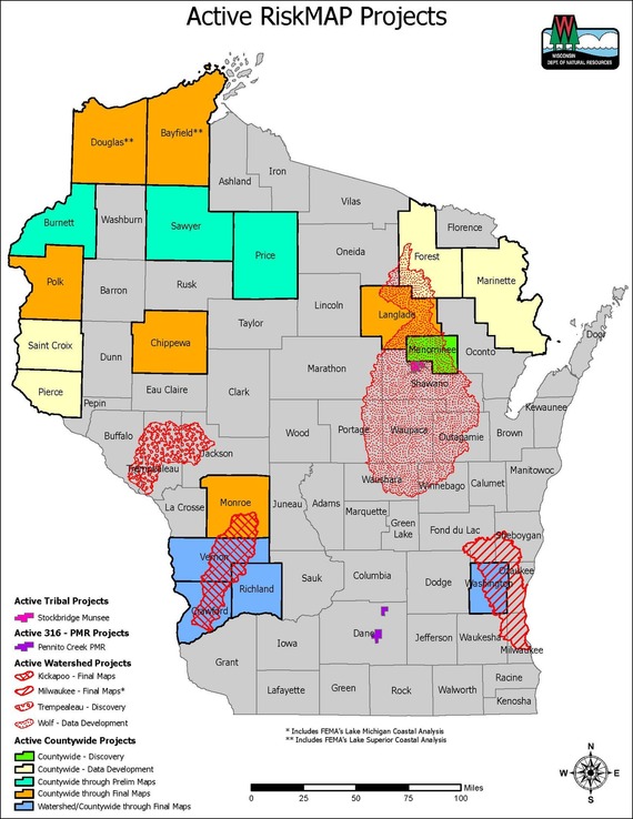
RiskMAP is a FEMA-led process, facilitated by the Wisconsin DNR and used to update or create FIRMs. The FIRMs and other data sets created during this process are used to help move communities toward flood resilience. Flood risk datasets work alongside regulatory products, like Flood Insurance Rate Maps (FIRMs) and the Flood Insurance Study (FIS), to provide flood risk information and support the community's floodplain management and hazard mitigation strategies.
There are several key meetings and milestones that occur throughout the RiskMAP project lifecycle, which are listed below. To learn more about each of these steps please visit FEMA’s Lifecycle of a RiskMAP Project webpage.
-
Discovery: FEMA and the RiskMAP project team meet with representatives from the communities to gather information on local flood risk priorities and any available data.
-
Project Kickoff Meeting: The RiskMAP project team may hold this meeting to introduce communities to project specifics and scope of work prior to data development.
-
Data Development: If a study is funded, hydrologic and hydraulic modeling is completed and the latest LiDAR topographic data is acquired for mapping.
-
Flood Risk Review (FRR) and Resilience Meetings: When data development is finished, draft flood hazard data is presented to the communities for review and any non-regulatory products (e.g., flood depth and analysis girds, changes since last FIRM, and/or areas of mitigation interest) that were created are also made available.
-
Preliminary Flood Map Release: Once preliminary products (FIRMs and the FIS) have been released, they can be viewed at FEMAs Map Service Center by selecting the appropriate county and community from the jurisdiction menu.
-
Consultation Coordination Officer (CCO) Meeting and Public Open House: After preliminary release, the CCO meeting presents the new mapping to local officials, followed by an open house for the public to view the changes.
-
90-Day Comment and Appeal Period: Following two public notices in a local newspaper, this 90-day period allows the opportunity for comments and appeals to be submitted on the updated maps. Appeals must meet standard requirements, and any submissions should be routed through community zoning administrators prior to review.
-
The Letter of Final Determination (LFD) and Effective Date: FEMA sends the LFD letter to the community’s chief executive officer stating that the final notice of flood hazard determinations will be published in the Federal Register and the new or updated FIRMs and FIS will soon reach effective status. The receipt of this letter starts the 6-month adoption phase of the process. This is where communities need to update their floodplain ordinances to incorporate the updated FIRMs and FIS by the federal effective date to remain in good standing in the National Flood Insurance Program (NFIP). Currently, most communities also update their floodplain zoning ordinance language so that the current regulations meet state and federal minimum standards. DNR floodplain staff can set up a draft floodplain zoning ordinance for the community to review. This assistance is provided by the DNR, to communities, free of charge. If you are interested, please email DNRFloodplain@Wisconsin.gov .
RiskMAP Project Timeline Dates
The table below details the timing of the Risk Mapping Meetings and anticipated Letter of Final Determination start dates for upcoming projects.
|
Project
|
Discovery
|
Project Kickoff Meeting
|
Flood Risk Review & Resilience Meeting
|
Preliminary Maps
|
CCO Meeting & Open House
|
90-Day Appeal Period
|
LFD Start
|
|
Vernon County (Kickapoo Watershed)
|
3/26/18
|
1/13/22
|
1/11/24
|
4/30/25
|
7/31/25 & 1/12/26
|
6/10/26 – 9/8/26
|
2/10/27*
|
|
Crawford County (Kickapoo Watershed)
|
3/26/18
|
1/13/22
|
1/11/24
|
3/15/25
|
8/05/25 & 1/14/26
|
6/4/26 – 9/2/26
|
2/24/27*
|
|
Monroe County (Kickapoo Watershed)
|
3/26/18
|
10/5/21
|
10/5/24
|
10/7/25
|
1/28/26
|
10/1/26 – 12/30/26*
|
Fall 2027*
|
|
Bayfield County
|
N/A
|
3/19/20
|
8/22/24
|
7/31/25
|
12/18/25 & 1/21/26
|
9/24/26 – 12/23/26*
|
Fall 2027*
|
|
Chippewa County
|
N/A
|
12/7/22
|
5/1/25
|
4/15/26
|
7/15/26
|
TBD
|
TBD
|
|
Sawyer County
|
N/A
|
5/20/21
|
8/27/26
|
TBD
|
TBD
|
TBD
|
TBD
|
|
Polk County
|
N/A
|
12/7/22
|
6/24/26
|
TBD
|
TBD
|
TBD
|
TBD
|
* – Dates are subject to change
N/A – projects with mapping needs previously identified or projects initiated by communities may follow a variation of the typical RiskMAP project timeline.
Burnett, Price, and Sawyer Counties have all had a project kickoff meeting and are all funded through the 90-Day Appeal Period with funding after that to be determined. St. Croix, Pierce, and Forest Counties as well as the Wolf Watershed (Outagamie and Waupaca Counties) have had project kickoff meetings and will all have Flood Risk Review & Resilience meetings, but funding beyond that stage is yet to be determined.
|