|
|
The Certified Floodplain Manager (CFM) program was established in 1998 by the Association of State Floodplain Managers (ASFPM) to create a certification for professional competence in floodplain management. By passing the exam and achieving continuing education credits annually, the CFM certification works to ensure that highly qualified individuals are able to meet the needs associated with our nation's floodplain issues. Across the state of Wisconsin, there are over 90 certified floodplain managers.
Read some insights below from Matt Heyroth, Jac Zader, Sara Strassman and Louie Greenwell about their experience as CFMs.
Matt Heyroth is the zoning administrator for Brown County and was asked by another zoning administrator about getting his CFM (inspiring this newsletter article). He provided this response:
“…[the CFM] was a great way to obtain a better understanding of federal rules versus state rules. … We collect over $50,000 in fees for floodplain permits and, obviously, there is a lot of risk if we mess something up related to proper building heights or location. So, in my mind, the roughly $700 spent on certifications and continuing education at conferences is well worth it for a county to have a staff person with these credentials and knowledge.”
Jac Zader is the assistant director of community development for the city of Mequon. He said that the process of getting his CFM gave him a better understanding of the rules and regulations he enforces and would recommend others in his field to consider it. The most challenging part for him is finding the time and money to meet the continuing education requirements.
Sara Strassman serves as the driftless area program manager for Trout Unlimited. Strassman explained that becoming a CFM has helped her understand floodplain regulations. She explained that studying for the exam was difficult due to limited online options; however, current improvements have resulted in a lot of great resources through ASFPM. Strassman also noted that many employers are not willing to cover the cost of the exam or study time. Overall, Strassman recommends that others who work with floodplains consider becoming a CFM.
Finally, Louie Greenwell, ASFPM’s certification, training & technology director, commented on his experience.
“It helped me distinguish myself among my peers as someone with the right credentials to help lead the team. Having the CFM and the requirement for continuing education also meant that I needed to attend conferences and workshops to continue learning about floodplain management. This enabled me to network with others that have helped me throughout my career…so I can truly say that the CFM program has shaped my career and had a significant impact on my life.”
Greenwell stated that people don’t often see the value of becoming a CFM. A recent survey by ASFPM shows that professionals holding the CFM credential reported an estimated average salary of just over $88,000. In contrast, respondents without a CFM or any other type of certification reported an estimated average salary of $64,500, a difference of roughly $23,500 annually. However, some of our state's CFMs notes that the credential's value comes less from salary benefits and more from improved knowledge of floodplain maps and regulations, along with networking opportunities.
If you are interested in pursuing your CFM, Greenwell hosts the quarterly CFM Exam Study webinar series, where he outlines the process to get certified and teaches people how to prepare. Study materials and CFM exam registration are available through the ASFPM website, including a self-paced on-demand study course. The exam can be taken in person or virtually.
|
|
|
The National Flood Insurance Program requires floodplain development permits for all development activities located in Special Flood Hazard Areas.
The Areas To Be Regulated Section (Section 1.5(1)) of the Wisconsin State Model Floodplain Zoning Ordinance states that zones A, AO, AH, A1-30, AE, VE, V1-30 or V shown on a Flood Insurance Rate Map are considered to be Special Flood Hazard Areas – or, in other words, all of the listed zones are considered to be regulated floodplains. Proposed development in these zones must go through the community’s permit process and meet requirements in the local floodplain ordinance.
Flood Insurance Rate Maps can be found in the FEMA Map Service Center.
If there are questions about proposed development activities, please contact the local community or the DNR water management engineer for assistance.
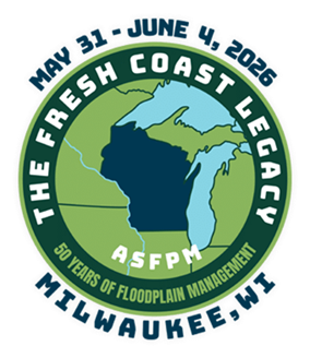
The Wisconsin Association of Floodplain, Stormwater, and Coastal Managers (WAFSCM) is hosting the 2026 Association of State Floodplain Managers (ASFPM) National Conference at the Baird Center in Milwaukee from May 31 – June 4, 2026.
The theme for ASFPM’s 50th Annual National Conference is “The Fresh Coast Legacy: 50 Years of Floodplain Management.” You do not need to be a member of ASFPM in order to attend the conference.
Register before April 15 to get early bird pricing. Options are available for both in-person and virtual attendance. Participation for the entire in-person conference earns 12 continuing education credits for certified floodplain managers.
All floodplain managers are encouraged to attend the conference to learn more about topics related to floodplain management, including flood risk identification/mapping and flood risk reduction and community resilience. Session topics include mitigation, modeling, mapping, National Flood Insurance Program, dams and levees, risk communication, extreme weather trends, natural and beneficial functions and a whole community approach to floodplain management. The program schedule is available online.
For more information, visit the ASFPM 2026 conference website.
|
Reminder: Waterway And Wetland Activity Questions
DNR water management specialists are responsible for implementing state regulations that protect waterways and wetlands. They review and make permit decisions for various activities proposed below the ordinary high water mark and located in wetlands. Additionally, they handle inquiries about whether a specific wetland area is eligible for a wetland exemption.
Information about common waterway and wetland activities and DNR permit requirements can be found on the DNR's Waterway Permit Frequently Asked Questions webpage.
All questions and inquiries about waterway and wetland activities should be submitted through DNR’s Waterways Questions and Complaint Form.
As a reminder, local shoreland and floodplain zoning regulations may also apply to waterway and wetland activities, and local communities may also regulate uses allowed within wetlands. Local community contacts vary by the type of municipality – see below for who to contact:
-
Unincorporated Towns: If the activity is located within an unincorporated town, reach out to the county zoning office to determine if permits are required and find out what regulations may apply.
-
City or Village: If the activity is in a city or village, please contact the zoning administrator for the specific city or village. Counties do not have direct authority in a city or village unless contracted by the community.
RiskMAP is a FEMA-led process, facilitated by the Wisconsin DNR and used to update or create flood insurance rate maps (FIRMs). The FIRMs and other datasets created during this process are used to help move communities toward flood resiliency. Flood risk datasets work alongside regulatory products (Flood Insurance Rate Maps and the Flood Insurance Study) to provide flood risk information and support the community's floodplain management and hazard mitigation strategies. DNR Floodplain engineers and GIS mapping staff often play a crucial role in the development of RiskMAP projects. To see a list of current RiskMAP Projects, visit the DNR website.
 There are several key meetings and milestones that occur throughout the RiskMAP project lifecycle, which can take 3-5 years to complete.
-
Discovery Period – This is the first phase of the RiskMAP lifecycle with the goal of identifying risk. FEMA, state and local leaders will collect and review flood risk data and use this information to gather a complete picture of a community’s flood risk. Discovery helps determine whether a RiskMAP project is needed and what the scope of the project will be. Community officials within the project area play a critical role, as they provide feedback and details on specific flood risk challenges and concerns. This phase happens in the first year of the project.
-
Project Kickoff Meeting – This meeting introduces communities to project specifics and scope of work prior to data development. Desired input from community officials is discussed.
-
Flood Risk Review (FRR) and Resilience Meetings – These meetings are part of the analysis and mapping phase after data development has been completed. The purpose of the FRR meeting is to provide an overview of the engineering analyses, present draft work maps and datasets and collect feedback from community officials. During the Resilience meeting, the project team presents additional non-regulatory products (e.g. GIS layers that might include: Changes Since Last FIRM, Water Surface Elevation Grids, Flood Depth Grids and Areas of Mitigation Interest), which can be used to aid in developing mitigation strategies and contribute to a better overall understanding of flood risk. This can help communities plan for the future by discussing factors that contribute to flooding in project areas, as well as identifying ways to reduce the risk. Following the completion of draft mapping, it can take approximately 6-12 months to reach the preliminary map status.
-
Preliminary Flood Map Release – Once preliminary products (Flood Insurance Rate Maps and the Flood Insurance Study) have been released, they can be viewed in FEMA's Map Service Center by selecting the appropriate county and community from the jurisdiction menu. After preliminary release, there’s typically another 12-18 months before the maps will reach effective or legal regulatory status.
-
Consultation Coordination Officer (CCO) Meeting and Public Open House – The CCO meeting is sponsored by FEMA with presentations by the state of Wisconsin floodplain mapping staff. The purpose is to present the preliminary FIRMs and FIS report and gather feedback on the products from local officials. Following the CCO meeting, a Public Open House provides community members the opportunity to view maps, ask questions and learn about local flood risks and resources available to reduce risk. Local communities are urged to promote the Public Open House, so community members are aware of the proposed map changes. The CCO meeting and Open House are typically scheduled a month or two after the preliminary map release.
-
90-Day Comment and Appeal Period – Following two public notices in a local newspaper, this 90-day period allows the opportunity for comments and appeals to be submitted on the updated maps. Appeals must meet standard requirements, and any submissions should be routed through community zoning administrators prior to review.
-
Letter of Final Determination and Effective Date are the final milestone in a flood risk project. FEMA sends the Letter of Final Determination to the community executive officer stating that the final notice of flood hazard determinations will be published in the Federal Register and new or updated flood insurance rate maps will soon reach effective status. The receipt of this letter starts the six-month adoption phase of the process. This is where communities need to update their floodplain ordinances to incorporate the updated maps and FIS, by the federal effective date to remain in good standing in the National Flood Insurance Program (NFIP). Currently, most communities also update their floodplain zoning ordinance language so that the current regulations meet state and federal minimum standards. DNR floodplain staff can set up a draft floodplain zoning ordinance for the community to review. This assistance is provided, by the DNR, to communities free of charge. If you are interested, please email DNRFloodplain@wisconsin.gov.
Additional details on the steps throughout the RiskMap process are available on FEMA’s website.
The table below details the timing of the Risk Mapping Meetings and anticipated Letter of Final Determination start dates for upcoming projects.
|
Project
|
Discovery
|
Project Kickoff Meeting
|
Flood Risk Review And Resilience Meeting
|
Preliminary Maps
|
CCO Meeting/ Open House
|
90-Day Appeal Period
|
LFD Start
|
|
Douglas County
|
N/A
|
March 20, 2020
|
Jan. 25, 2023
|
Dec. 2, 2024
|
Jan. 23, 2025
|
Aug. 1 – Oct. 30, 2025
|
June 10, 2026*
|
|
Monroe County (Kickapoo Watershed)
|
March 26, 2018
|
Oct. 5, 2021
|
June 5, 2024
|
Oct. 7, 2025
|
Jan. 28, 2026
|
TBD
|
TBD
|
|
Vernon County
(Kickapoo Watershed)
|
March 26, 2018
|
Jan. 13, 2022
|
Jan. 11, 2024
|
April 30, 2025
|
July 31, 2025
Jan. 12, 2026
|
TBD
|
TBD
|
|
Richland County (Kickapoo Watershed)
|
March 26, 2018
|
Jan. 13, 2022
|
Jan. 11, 2024
|
Jan. 31, 2025
|
March 18, 2025
|
Sept. 18 – Dec. 17, 2025
|
TBD
|
|
Crawford County (Kickapoo Watershed)
|
March 26, 2018
|
Jan. 13, 2022
|
Jan. 11, 2024
|
May 15, 2025
|
Aug. 5, 2025
Jan. 14, 2026
|
TBD
|
TBD
|
|
Bayfield County
|
N/A
|
March 19, 2020
|
Aug. 22, 2024
|
July 31, 2025
|
Jan. 21, 2026
|
TBD
|
TBD
|
|
Chippewa County
|
N/A
|
Dec. 7 2022
|
May 1, 2025
|
April 15, 2026*
|
TBD
|
TBD
|
TBD
|
|
St. Croix County
|
N/A
|
Sept. 29, 2025
|
TBD
|
TBD
|
TBD
|
TBD
|
TBD
|
|
Pierce County
|
N/A
|
Jan. 29, 2026
|
TBD
|
TBD
|
TBD
|
TBD
|
TBD
|
|
Burnett County
|
N/A
|
Feb. 10, 2026
|
TBD
|
TBD
|
TBD
|
TBD
|
TBD
|
|
Price County
|
N/A
|
Jan. 24, 2022
|
TBD
|
TBD
|
TBD
|
TBD
|
TBD
|
|
Sawyer County
|
N/A
|
May 20, 2021
|
TBD
|
TBD
|
TBD
|
TBD
|
TBD
|
|
Outagamie County (Wolf Watershed)
|
N/A
|
Oct. 10, 2023
|
TBD
|
TBD
|
TBD
|
TBD
|
TBD
|
|
Waupaca County (Wolf Watershed)
|
N/A
|
Oct. 10, 2023
|
TBD
|
TBD
|
TBD
|
TBD
|
TBD
|
|
Polk County
|
N/A
|
Dec. 7, 2022
|
TBD
|
TBD
|
TBD
|
TBD
|
TBD
|
|
Trempealeau Watershed (Buffalo, Jackson, Trempealeau Counties)
|
TBD
|
N/A
|
N/A
|
N/A
|
N/A
|
N/A
|
N/A
|
|
Menominee County
|
TBD
|
N/A
|
N/A
|
N/A
|
N/A
|
N/A
|
N/A
|
|
Stockbridge Munsee (Shawano County)
|
TBD
|
N/A
|
N/A
|
N/A
|
N/A
|
N/A
|
N/A
|
* – Dates are subject to change
Bolded dates highlight what is happening next.
N/A – projects with mapping needs previously identified or projects initiated by communities may follow a variation of the typical RiskMAP project timeline
|
|
|
About The Wisconsin Floodplain Management Program
The program's goals are to protect life, health and property; to minimize costs for flood control projects; to reduce tax dollars spent for rescue, relief and repair of flood damage; to shorten business interruptions caused by flooding; to prevent future flood blight areas; to discourage victimization of unwary land and home buyers; and to prevent increased flood levels caused by unwise floodplain development. Municipalities (counties, cities and villages) implement the statewide floodplain standards under Chapter NR 116 (Wis. Adm. Code).
About The Wisconsin Shoreland Management Program
The purpose and intent (goals) of shoreland zoning are to protect water quality, fish and wildlife habitat, recreation and natural beauty. Counties implement the statewide shoreland zoning standards under Chapter NR 115 (Wis. Adm. Code). The standards apply only to unincorporated land that is within 1,000 feet of the ordinary high-water mark of a lake, pond or flowage, within 300 feet of the ordinary high-water mark of a river or stream or to the landward side of the floodplain, whichever distance is greater.
Contact Us
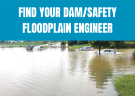
Floodplain: Sarah Rafajko, Sarah.Rafajko@wisconsin.gov
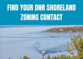
Shoreland: Sue Vanden Langenberg, Susan.VandenLangenberg@wisconsin.gov
Dam Safety: Uriah Monday, Uriah.Monday@wisconsin.gov
|
|
|
Floodplain and Shoreland Management Notes is published by the Wisconsin Department of Natural Resources' Waterways Bureau. The purpose of the newsletter is to inform local zoning officials and others concerned about state and federal floodplain management, flood insurance, shoreland and wetland management, and dam safety issues. Comments or contributions are welcome. Please send comments to DNRFloodplain@wisconsin.gov.
This newsletter is supported by funding through the FEMA Cooperative Agreement as part of the Community Assistance Program-State Support Services Element of the National Flood Insurance Program. The contents do not necessarily reflect the views and policies of the federal government.
|
|
|
|
|