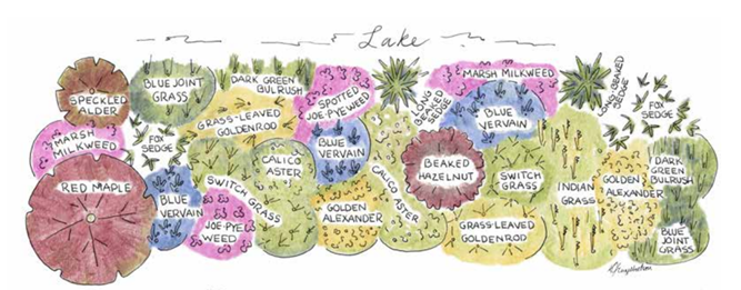
 Photo Credit: The Healthy Lakes & Rivers Program Native Shoreland Planting Companion Guide
Native vegetation along a shoreline improves wildlife and aquatic habitat, prevents and slows surface water runoff, creates privacy, and promotes natural scenic beauty. It can also attract birds and pollinating insects, create shady areas, reduce yard maintenance and may discourage unwanted wildlife such as Canadian geese from entering the property.
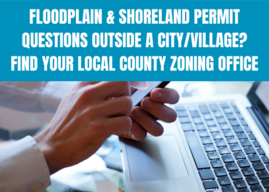
These benefits also align with reasons why shoreland zoning exists in our state. Shoreland zoning standards originate from Wis. Stats. s. 59.692 and Wis. Adm. Code NR 115, but are regulated and enforced by counties through County Shoreland Zoning Ordinances. One shoreland zoning standard involves maintaining a 35-foot vegetative buffer zone along the shoreline, starting at the ordinary high water mark (OHWM) and extending landward. Property owners can contact their local county zoning administrator to learn more about shoreland zoning and factors to consider before making improvements to the vegetative buffer zone.
Once a decision has been made to restore native vegetation along a shoreline, property owners can choose from a variety of native plants like trees, shrubs, wildflowers and grasses. Native plants, compared to turf grass, have larger and stronger root systems to hold soil in place, protecting from the erosive effects of runoff and wave action and acting as a natural filter for nutrients. For information on how to restore a shoreline with native vegetation, see the Healthy Lakes & Rivers Program Native Shoreland Planting Companion Guide. Available year-round are Cost Share grants to fund shoreline native plants and other Healthy Lakes & Rivers best practices.
Selecting native species for shoreline plantings will help protect our waterbodies for years to come.
Municipal Flood Control Grant 2026 Application Cycle Opening This Fall
The 2026 Municipal Flood Control (MFC) grant application period will open on Oct. 15, 2025. This grant funding is available to all cities, villages, towns, tribal governments and metropolitan sewerage districts concerned with municipal flood control management. Counties may cooperate with an eligible applicant.
This grant program is intended to proactively mitigate the impacts of a changing climate, reduce flood hazard vulnerabilities, and improve the resilience and preparedness of Wisconsin municipalities. The initial projected funding available for this grant cycle is $3 million. The grant period is two years, with a possible one-year extension with written justification.
The Municipal Flood Control Grant is a priority-based program. The following eligible project types are listed in the priority order in which they will be ranked according to Wisconsin Administrative Code. Project types 1 through 4 are determined by structure location within floodplain district boundaries on a Flood Insurance Rate Map.
|
Project Type
|
Description
|
|
1
|
Property acquisition and removal of structures which, due to zoning restrictions, cannot be rebuilt (structure located directly in floodway, dam shadow or Zone A)
|
|
2
|
Property acquisition and removal of structures in the 100-year floodplain (structure located in flood fringe)
|
|
3
|
Property acquisition and removal of repetitive loss or substantially damaged structure (outside the floodplain but meets the definition of “Repetitive Loss Structure” in NR 199.03(17) and/or “Substantial Damage” in NR 199.03(20))
|
|
4
|
Property acquisition and removal of flood-damaged structures (any flood-damaged structure outside floodplain)
|
|
5
|
Floodproofing and flood elevation project in the 100-year floodplain that will remain in the 100-year floodplain
|
|
6
|
Riparian Restoration project on a watercourse: (1) dam or artificial obstruction removal; (2) fish & native plant habitat restoration; (3) erosion control and streambank restoration
|
|
7
|
Acquisition of vacant land for flood water control/storage or flood water flowage easement
|
|
8
|
Flood control detention pond
|
|
9
|
Flood studies and flood mapping projects
|
For more information, including how to apply, please visit the DNR's Municipal Flood Control Grant Program webpage. The application deadline is 4 p.m. on March 16, 2026.
For grant application assistance and questions, contact NR MFC Grant Program Manager Lis Kuisis at Elisabeth.Kuisis@wisconsin.gov.
For technical information and questions, contact DNR NFIP Coordinator Sarah Rafajko at Sarah.Rafajko@wisconsin.gov.
Oct. 15-16, 2025 – Eau Claire
The Wisconsin Association for Floodplain, Stormwater, and Coastal Management (WAFSCM) will hold its 23rd Annual Conference on Wednesday, Oct. 15, through Thursday, Oct. 16, at the Lismore Hotel in Eau Claire, Wisconsin. Professional Development Hours (PDHs) and Continuing Education Credits (CECs) can be earned at the main conference on Wednesday and Thursday. A field tour, workshops and a social reception will be held on Wednesday, and the main conference will include plenary and speaker sessions throughout the day on Thursday.
The Certified Floodplain Manager (CFM) exam is not planned to be conducted at the conference this year, but is being offered online by ASFPM. See the Floodplain Manager Certification page for more information. More information for the WAFSCM conference can be found on the WAFSCM website.
– Article from WAFSCM website
May 31-June 4, 2026 – Milwaukee
Join us on the shores of Lake Michigan in Milwaukee, Wisconsin, for a landmark event—ASFPM’s 50th Annual National Conference, themed: “The Fresh Coast Legacy: 50 Years of Floodplain Management.”
From May 31 to June 4, 2026, this milestone event celebrates five decades of progress in flood risk reduction and community resilience across the nation. Conference highlights includes 200+ concurrent sessions led by experts from across the field, field tours and hands-on workshops that bring real-world solutions to life, robust networking opportunities with professionals, policymakers, and partners, and inspiring plenary sessions reflecting on the past and envisioning the future.
Registration for the conference begins February 2026, and more information can be found on the ASFPM website.
– Article from ASFPM website
|

Jen Jefferson, DNR Dam Safety and Floodplain Section Manager, started this position formerly held by Tanya Lourigan in June. Jen supports the DNR National Flood Insurance Program (NFIP) Coordinator, DNR State Floodplain Engineer, DNR State Dam Safety Engineer, along with DNR Water Management Engineers and others, to oversee floodplains and dams across the state. Jen works out of the Milwaukee Service Center.
Jen is originally from Iowa and completed her undergraduate and Master’s degrees in Civil & Environmental Engineering, along with a PhD in hydrology. She has gained technical expertise through engineering experience in both the private and public sectors, including as a DNR Water Management Engineer. Most recently, Jen worked as a design project manager for urban stream projects and as the DNR Surface Water Grant program manager. She is excited to return to the DNR Waterways program!
|

Bill Roznik, DNR Floodplain Engineer, started with the DNR Dam Safety and Floodplain program in July. Bill works with other floodplain engineers in the program to develop and update hydrologic and hydraulic models and floodplain maps across the state. Bill works out of Madison.
Bill grew up in Green Bay and spent a lot of time outdoors along the shore and tributaries of Lake Michigan, which shaped his appreciation for natural spaces and inspired his collegiate and career aspirations. Bill earned degrees in Physics and Civil & Environmental Engineering and has spent much of his career as an engineering consultant completing the design and permitting for projects to stabilize shorelines, create public waterfront access, and build resilient waterfront spaces along rivers and lakes throughout the Midwest.
|
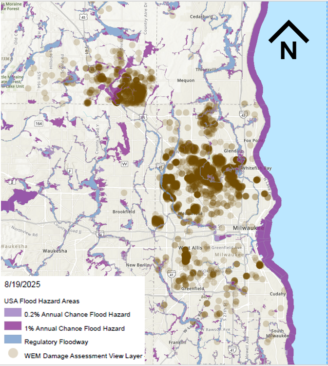
RiskMAP is a FEMA-led process, facilitated by the Wisconsin DNR and used to update or create flood insurance rate maps (FIRMs). The FIRMs and other datasets created during this process are used to help move communities toward flood resiliency. Flood risk datasets work alongside regulatory products to provide flood risk information and support the community's floodplain management and hazard mitigation strategies. DNR Floodplain engineers and GIS mapping staff often play a crucial role in the development of RiskMAP projects. To see a list of current RiskMAP Projects, visit the website.
There are several key meetings and milestones that occur throughout the RiskMAP project lifecycle, which can take 3-5 years to complete.
-
Discovery Period – This is the first phase of the RiskMAP lifecycle with the goal of identifying risk. FEMA, state and local leaders will collect and review flood risk data and use this information to gather a complete picture of a community’s flood risk. Discovery helps determine whether a RiskMAP project is needed and what the scope of the project will be. Community officials within the project area play a critical role, as they provide feedback and details on specific flood risk challenges and concerns. This phase happens in the first year of the project.
-
Project Kickoff Meeting – This meeting introduces communities to project specifics and scope of work prior to data development. Desired input from community officials is discussed.
-
Flood Risk Review (FRR) And Resilience Meetings – These meetings are part of the analysis and mapping phase after data development has been completed. The purpose of the FRR meeting is to provide an overview of the engineering analyses, present draft work maps and datas, and collect feedback from community officials. During the Resilience meeting, the project team presents additional non-regulatory products, which can be used to aid in developing mitigation strategies and contribute to a better overall understanding of flood risk. This can help communities plan for the future by discussing factors that contribute to flooding in project areas, as well as identifying ways to reduce the risk. Following the completion of draft mapping, it can take approximately 6-12 months to reach the preliminary map status.
-
Preliminary Flood Map Release – Once preliminary products have been released, they can be viewed at FEMAs Map Service Center by selecting the appropriate county and community from the jurisdiction menu. After preliminary release, there’s typically another 12-18 months before the maps will reach effective status.
-
Consultation Coordination Officer (CCO) Meeting And Public Open House – The CCO meeting is sponsored by FEMA with presentations by the state of Wisconsin floodplain mapping staff. The purpose is to present the preliminary FIRMs and FIS report and gather feedback on the products from local officials. Following the CCO meeting, a Public Open House provides citizens the opportunity to view maps, ask questions, learn about local flood risks and resources available to reduce risk. Local communities are urged to promote the Public Open House so citizens are aware of the proposed map changes. The CCO meeting and Open House are typically scheduled a month or two after the preliminary map release.
-
90-Day Comment And Appeal Period – Following two public notices in a local newspaper, this 90-day period allows the opportunity for comments and appeals to be submitted on the updated maps. Appeals must meet standard requirements, and any submissions should be routed through community zoning administrators prior to review.
Additional details on the steps throughout the RiskMap process are available on FEMA’s website.
Letter of Final Determination (LFD) and effective date are milestones in a flood risk project. The Letter of Final Determination is sent to the community executive stating that the final notice of flood hazard determinations will be published in the Federal Register and new or updated flood insurance rate maps will soon reach effective status. The receipt of this letter starts the 6-month adoption phase of the process. This is where communities need to update their floodplain ordinances to incorporate the updated maps and FIS, by the federal effective date to remain in good standing in the National Flood Insurance Program (NFIP). Currently, most communities also update their floodplain zoning ordinance language so that the current regulations meet state and federal minimum standards. DNR floodplain staff can set up a draft floodplain zoning ordinance for the community to review. Our assistance is provided to communities free of charge. If you are interested, please get in touch with DNR at DNRFloodplain@Wisconsin.gov.
The table below details the timing of the Risk Mapping Meetings and anticipated Letter of Final Determination start dates for upcoming projects.
|
Project
|
Discovery
|
Project Kickoff Meeting
|
Flood Risk Review and Resilience Meeting
|
Preliminary Maps
|
CCO Meeting/Open House
|
90-Day Appeal Period
|
LFD Start
|
|
Washington County
(Milwaukee Watershed)
|
May 16, 2013
|
N/A
|
Aug. 28, 2019
|
March 20, 2024
|
May 2, 2024
|
Sept. 27-Dec. 26, 2024
|
Aug. 20, 2025
|
|
Langlade County
|
N/A
|
April 29, 2020
|
April 14, 2023
|
April 30, 2024
|
May 29, 2024
|
Sept. 13-Dec. 12, 2024
|
Sept. 17, 2025*
|
|
Douglas County
|
N/A
|
March 20, 2020
|
Jan. 25, 2023
|
Dec. 2, 2024
|
Jan. 23, 2025
|
Aug. 1 – Oct. 30, 2025
|
TBD
|
|
Monroe County (Kickapoo Watershed)
|
March 26, 2018
|
Oct. 5, 2021
|
June 5, 2024
|
Oct. 7, 2025*
|
TBD
|
TBD
|
TBD
|
|
Vernon County
(Kickapoo Watershed)
|
March 26, 2018
|
Jan. 13, 2022
|
Jan. 11, 2024
|
April 30, 2025
|
July 31, 2025
|
TBD
|
TBD
|
|
Richland County (Kickapoo Watershed)
|
March 26, 2018
|
Jan. 13, 2022
|
Jan. 11, 2024
|
Jan. 31, 2025
|
March 18, 2025
|
Sept. 18 – Dec. 17, 2025*
|
TBD
|
|
Crawford County (Kickapoo Watershed)
|
March 26, 2018
|
Jan. 13, 2022
|
Jan. 11, 2024
|
May 15, 2025
|
Aug. 5, 2025
|
TBD
|
TBD
|
|
Bayfield County
|
N/A
|
March 19, 2020
|
Aug. 22, 2024
|
July 31, 2025
|
TBD
|
TBD
|
TBD
|
|
Chippewa County
|
N/A
|
Dec. 7 2022
|
May 1, 2025
|
TBD
|
TBD
|
TBD
|
TBD
|
|
St. Croix County
|
N/A
|
Sept. 29, 2025*
|
TBD
|
TBD
|
TBD
|
TBD
|
TBD
|
|
Outagamie County (Wolf Watershed)
|
N/A
|
Oct. 10, 2023
|
TBD
|
TBD
|
TBD
|
TBD
|
TBD
|
|
Waupaca County (Wolf Watershed)
|
N/A
|
Oct. 10, 2023
|
TBD
|
TBD
|
TBD
|
TBD
|
TBD
|
|
Polk County
|
N/A
|
Dec. 7, 2022
|
TBD
|
TBD
|
TBD
|
TBD
|
TBD
|
|
Trempealeau Watershed (Buffalo, Jackson, Trempealeau Counties)
|
TBD
|
N/A
|
N/A
|
N/A
|
N/A
|
N/A
|
N/A
|
|
Menominee County
|
TBD
|
N/A
|
N/A
|
N/A
|
N/A
|
N/A
|
N/A
|
|
Stockbridge Munsee (Shawano County)
|
TBD
|
N/A
|
N/A
|
N/A
|
N/A
|
N/A
|
N/A
|
* – Dates are subject to change
Bolded dates are those that have occurred since the last newsletter or are upcoming.
N/A – projects with mapping needs previously identified or projects initiated by communities may follow a variation of the typical RiskMAP project timeline
|