|
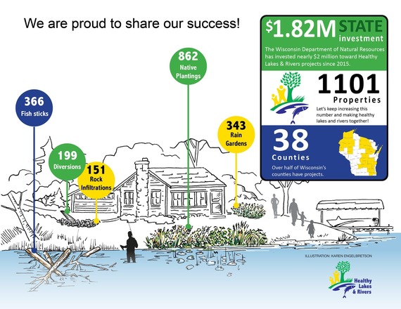
The Healthy Lakes & Rivers program includes five simple and inexpensive best practices that improve habitat and water quality on your shoreland property. While these practices are DIY friendly, the DNR Surface Water Grant program also offers funding assistance through cost-share grants. Since 2015, the DNR has been able to award $1.82 million in these cost-share grants to over 1,000 landowners across 38 counties. Through these grants, 1,921 shoreland health best practices have been installed along 205 lakes and rivers across the state. The Healthy Lakes & Rivers program is a partnership among the Wisconsin DNR, Extension Lakes, Wisconsin Lakes, and local partner organizations. Each of these groups contributes to making the program work: grant administration, communications, partnership building, technical guidance, site visits, project design, outreach, and more.
 If you belong to a lake or river organization, municipality, or tribal government, you can help make Healthy Lakes & Rivers together in your community! While the DNR cannot provide Healthy Lakes & Rivers funding directly to individual shoreland property owners, the groups mentioned above can apply for up to $25,000 on behalf of multiple property owners ($1,000 per best practice) and grant applications are now accepted year-round (one per fiscal year). No pre-application is required, but first-time applicants must provide photos and design plans for approval to their regional DNR biologist prior to implementation.
For more information on this partnership, the five best practices and grant resources, visit the Healthy Lakes & Rivers website.
Article and image reprinted from Lake Tides newsletter Vol. 50, No. 1.
The DNR Waterways Program fields thousands of questions annually about “buildability” or “Are there wetlands on this property and what does it mean?”
DNR Waterways staff, including intake specialists, water management specialists and wetland identification specialists, use a quick wetland screening process to establish an initial understanding of the likelihood of wetlands on a property. Landowners, local governments, realtors and consultants can follow these steps to determine if further wetland identification is necessary.
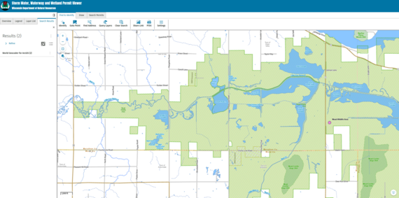
Wetland Map Screening
1. On the publicly available Storm Water, Waterway and Wetland Permit Viewer, zoom into a parcel or property using an address or latitude and longitude. A property can also be found using nearby roads and landmarks, zooming in manually, and confirming the parcel number using the DOA Statewide Parcel Map layer.
2. Turn on the "Mapped Wetlands and Wetland Indicators & Soils" layer to view the wetland maps. The mapped wetlands layer will show an orange boundary with dots, and the wetland indicators layer will show a purple boundary with dots.
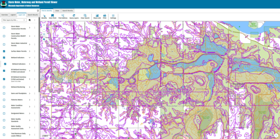 If the map screening shows no mapped wetlands or indicators on the site, there is a low likelihood of wetlands on the property. Unless there is additional evidence of wetlands, such as hydrophilic vegetation (e.g., cattails, reed canary grass, etc.), wet areas for part of the year, or low spots, then further wetland identification is not required, and no DNR wetland permits are needed.
If the map screening shows mapped wetlands or indicators on the property, there are two options for proceeding.
DNR Wetland Identification Service – For Wetland Avoidance
If a landowner wants to avoid wetlands entirely with their project and also avoid needing to apply for a DNR wetland permit, then they should use the wetland ID service. This service is a field survey completed by DNR Wetland ID Specialists who provide a yes/no boundary for avoidance purposes. The service can be requested for $300 per acre up to 5 acres on a property and is typically only feasible during the growing season. If you are unsure about whether you need this service for your project, please submit a question through the DNR's Waterways Question and Complaint Form.
Wetland Delineation By A Consultant – When Wetlands Cannot Be Avoided
If a landowner determines that they cannot avoid wetlands with the project, or if there are no upland alternatives on the property given the project scope and location, then a full wetland delineation will be needed. Wetland delineations must be submitted with wetland permit applications and requests for nonfederal or artificial exemptions. DNR does not complete wetland delineations, but there are typically multiple local options. Search “wetland delineator” or “wetland consultant” in your region for options.

Dale Rezabek, DNR shoreland zoning specialist, will retire from the department after 14 years of service. Dale spent 24 years as a hydrogeologist in the private sector before joining the DNR. He came to the DNR in 2011 to work in the Wastewater Bureau before he started with the Waterway Bureau as a shoreland zoning specialist in 2014 to finish out his service career.
A big congratulations and thank you to Dale for his excellent customer service to all the counties and communities he assisted and all his contributions to the DNR! He has been a steadfast member of the DNR Shoreland Zoning Team, hard worker, and passionate about the DNR Shoreland Program!
We speak for everyone at the DNR when we say that he will be missed dearly, but we all wish him happiness, relaxation and time to travel and enjoy the outdoors.
|

Kay Lutze, DNR shoreland team supervisor and northeast region waterways field supervisor, will retire from the department after 11 years of service. Kay also worked as a limited-term employee at Potawatomi State Park for 8 years before earning her master’s degree in environmental science from UW-Green Bay. She then worked as a zoning administrator for Door County for 17 years before coming back to the DNR as the shoreland zoning program coordinator and eventually a supervisor.
In her various public servant roles, Kay has resonated with many walks of life—customers and colleagues. She has put out many words of wisdom and much training content to help others grow and succeed around her. Kay has a kind heart and has consistently offered her strengths intentionally and mindfully so that others can flourish.
A big congratulations and thank you to Kay for her leadership, training and assistance to counties and communities - and all her contributions to the DNR! She is passionate about the fundamental principles and the people responsible for upholding shoreland zoning and wetlands and waterways which are paramount to upholding the Public Trust. Kay’s work with natural resources has a lasting impact not only on the landscape but also on her teams and colleagues.
We speak for everyone at the DNR when we say that she will leave some big shoes to fill. We hope she finds more time for bike trips, camping, fishing and relaxing with a good book.
|
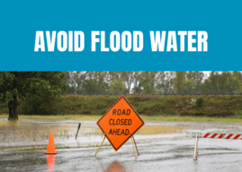
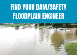
RiskMAP is a FEMA-led process, facilitated by the Wisconsin DNR and used to update or create flood insurance rate maps (FIRMs). The FIRMs and other datasets created during this process are used to help move communities toward flood resiliency. Flood risk datasets work alongside regulatory products to provide flood risk information and support the community's floodplain management and hazard mitigation strategies. DNR Floodplain engineers and GIS mapping staff often play a crucial role in the development of RiskMAP projects. To see a list of current RiskMAP Projects, visit the website.
There are several key meetings and milestones that occur throughout the RiskMAP project lifecycle, which can take 3-5 years to complete.
-
Discovery Period – This is the first phase of the RiskMAP lifecycle with the goal of identifying risk. FEMA, state and local leaders will collect and review flood risk data and use this information to gather a complete picture of a community’s flood risk. Discovery helps determine whether a RiskMAP project is needed and what the scope of the project will be. Community officials within the project area play a critical role, as they provide feedback and details on specific flood risk challenges and concerns. This phase happens in the first year of the project.
-
Project Kickoff Meeting – This meeting introduces communities to project specifics and scope of work prior to data development. Desired input from community officials is discussed.
-
Flood Risk Review (FRR) And Resilience Meetings – These meetings are part of the analysis and mapping phase after data development has been completed. The purpose of the FRR meeting is to provide an overview of the engineering analyses, present draft work maps and datas, and collect feedback from community officials. During the Resilience meeting, the project team presents additional non-regulatory products, which can be used to aid in developing mitigation strategies and contribute to a better overall understanding of flood risk. This can help communities plan for the future by discussing factors that contribute to flooding in project areas, as well as identifying ways to reduce the risk. Following the completion of draft mapping, it can take approximately 6-12 months to reach the preliminary map status.
-
Preliminary Flood Map Release – Once preliminary products have been released, they can be viewed at FEMAs Map Service Center by selecting the appropriate county and community from the jurisdiction menu. After preliminary release, there’s typically another 12-18 months before the maps will reach effective status.
-
Consultation Coordination Officer (CCO) Meeting And Public Open House – The CCO meeting is sponsored by FEMA with presentations by the state of Wisconsin floodplain mapping staff. The purpose is to present the preliminary FIRMs and FIS report and gather feedback on the products from local officials. Following the CCO meeting, a Public Open House provides citizens the opportunity to view maps, ask questions, learn about local flood risks and resources available to reduce risk. Local communities are urged to promote the Public Open House so citizens are aware of the proposed map changes. The CCO meeting and Open House are typically scheduled a month or two after the preliminary map release.
-
90-Day Comment And Appeal Period – Following two public notices in a local newspaper, this 90-day period allows the opportunity for comments and appeals to be submitted on the updated maps. Appeals must meet standard requirements, and any submissions should be routed through community zoning administrators prior to review.
Additional details on the steps throughout the RiskMap process are available on FEMA’s website.
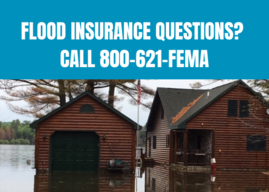
Letter of Final Determination (LFD) and effective date are milestones in a flood risk project. The Letter of Final Determination is sent to the community executive stating that the final notice of flood hazard determinations will be published in the Federal Register and new or updated flood insurance rate maps will soon reach effective status. The receipt of this letter starts the 6-month adoption phase of the process. This is where communities need to update their floodplain ordinances to incorporate the updated maps and FIS, by the federal effective date to remain in good standing in the National Flood Insurance Program (NFIP). Currently, most communities also update their floodplain zoning ordinance language so that the current regulations meet state and federal minimum standards. DNR floodplain staff can set up a draft floodplain zoning ordinance for the community to review. Our assistance is provided to communities free of charge. If you are interested, please get in touch with DNR at DNRFloodplain@Wisconsin.gov.
The table below details the timing of the Risk Mapping Meetings and anticipated Letter of Final Determination start dates for upcoming projects.
|
Project
|
Discovery
|
Project Kickoff Meeting
|
Flood Risk Review and Resilience Meeting
|
Preliminary Maps
|
CCO Meeting/Open House
|
90-Day Appeal Period
|
LFD Start
|
|
Dane County (Pennito Creek PMR)
|
N/A
|
N/A
|
N/A
|
July 11, 2023
|
Aug. 29, 2023
|
Dec. 14 2023 – March 13, 2024
|
Oct. 9, 2024
|
|
Washington County
(Milwaukee Watershed)
|
May 16, 2013
|
N/A
|
Aug. 28, 2019
|
March 20, 2024
|
May 2, 2024
|
Sept. 27-Dec. 26, 2024
|
Aug. 20, 2025*
|
|
Langlade County
|
N/A
|
April 29, 2020
|
April 14, 2023
|
April 30, 2024
|
May 29, 2024
|
Sept. 13-Dec. 12, 2024
|
Sept. 17, 2025*
|
|
Douglas County
|
N/A
|
March 20, 2020
|
Jan. 25, 2023
|
Dec. 2, 2024
|
Jan. 23, 2025
|
TBD
|
TBD
|
|
Monroe County (Kickapoo Watershed)
|
March 26, 2018
|
October 5, 2021
|
June 5, 2024
|
September 10, 2025
|
TBD
|
TBD
|
TBD
|
|
Vernon County
(Kickapoo Watershed)
|
March 26, 2018
|
Jan. 13, 2022
|
Jan. 11, 2024
|
April 30, 2025
|
TBD
|
TBD
|
TBD
|
|
Richland County (Kickapoo Watershed)
|
March 26, 2018
|
Jan. 13, 2022
|
Jan. 11, 2024
|
Jan. 31, 2025
|
March 18, 2025
|
TBD
|
TBD
|
|
Crawford County (Kickapoo Watershed)
|
March 26, 2018
|
Jan. 13, 2022
|
Jan. 11, 2024
|
May 15, 2025
|
TBD
|
TBD
|
TBD
|
|
Bayfield County
|
N/A
|
March 19, 2020
|
August 22, 2024
|
July 31, 2025*
|
TBD
|
TBD
|
TBD
|
|
Chippewa County
|
N/A
|
Dec. 7 2022
|
May 1, 2025
|
TBD
|
TBD
|
TBD
|
TBD
|
* – Dates are subject to change
N/A – projects with mapping needs previously identified or projects initiated by communities may follow a variation of the typical RiskMAP project timeline
|