DNR Parks And Recreation News
What’s Happening In Wisconsin's State Parks, Forests, Trails And Recreation Areas
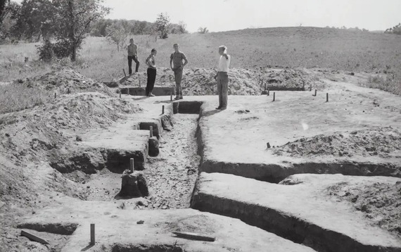 Archaeological work has helped unearth the history of Aztalan State Park, like this 1959 dig in what was likely a village center. / Photo Credit: Robert D. Espeseth/DNR Archives
Dig Into State History
The 125th anniversary of the Wisconsin State Park System is a great time to reflect on the history and importance of our state parks. In most cases, the story of these beautiful landscapes starts well before 1900.
Hundreds of recorded pre- and post-contact archaeological sites are located on DNR-managed lands. There is so much to discover, from early Indigenous sites such as mounds, rock art and villages to logging-era Civilian Conservation Corps (CCC) camps and everything in between. Below are a small number of our many archeologically rich properties to explore this year.
When visiting these sites, please remember that Wisconsin's cultural and historical sites are a shared, nonrenewable resource. Please stay on the trail at sensitive locations and leave flora, fauna and cultural materials in place.
Lizard Mound State Park
Lizard Mound is an indigenous burial ground and cultural landscape featuring one of the state's largest and most well-preserved effigy mound groups.
The property's effigy mounds have been interpreted as representing spiritual and/or animal-like forms, including birds, panthers or water spirits, and the eponymous lizard.
More than a mile of limestone and grass-surfaced trails loop throughout the property. A self-guided tour winds around 28 well-preserved burial mounds. Tribal nations consider the area sacred, and visitors are asked to respect the landscape and remember to remain on designated trails. Walking on the mounds is strictly prohibited.
There is an interactive interpretive center featuring cultural and historical information regarding the archeological aspects of the property.
Lizard Mound State Park now requires a vehicle admission pass for visitors.
Aztalan State Park
Aztalan State Park is a National Historic Landmark and contains one of Wisconsin's most important archaeological sites. It showcases an ancient Middle-Mississippian village that thrived between A.D. 1000 and 1300. The people who settled in Aztalan built large, flat-topped pyramidal mounds and stockades around their village.
Among the many artifacts found at the site are beautiful clay pots, uniquely fashioned arrow points, a figure of a Mississippian deity, shell beads, copper and stone ear decorations worn by nobility and warriors, large stone hoes imported from southern Illinois and small stone disks or wheels from a spear-throwing game called "chunkey."
Aztalan State Park covers 172 acres, including a large tract of forest on the east side of the Crawfish River. Two miles of trail meander through open prairie and along the river, giving visitors a view of the reconstructed stockade and mounds. The park has detailed interpretive signs throughout that discuss archaeological and cultural interpretations of the site.
Roche-A-Cri State Park
Roche-A-Cri State Park protects a 300-foot-high rock outcropping containing Native American petroglyphs and pictographs. The name "Roche-A-Cri" comes from French words meaning "screaming rock."
The abundance of rock art suggests that this place had special significance to the region's ancient inhabitants. The petroglyphs were estimated to be carved before A.D. 900, with the pictographs appearing only 400-500 years ago. The artists are believed to be ancestors of the Ho-Chunk people. Interpretive panels present interesting facts, drawings of the art and a map to help visitors locate carvings and paints on the mound.
Government survey notes taken in 1851 refer to "hieroglyphs of antiquated appearance" on the side and in a cave at Roche-A-Cri. The surveyors surmised that "from the appearance, they must have been written centuries ago."
Roche-A-Cri State Park has now reopened after a recent wildfire. The stairway to the top of the mound and trail around the base remain closed until further notice. All other hiking trails at the property are open.
High Cliff State Park
Between 1,000 and 1,500 years ago, local indigenous communities built a series of mounds along the bluffs overlooking Lake Winnebago, now within the confines of High Cliff State Park. There are four panther-shaped mounds, two buffalo-shaped mounds, conical mounds and a linear mound.
The Indian Mound Trail starts at the Indian Mound lot off Park Road and near campsite 14 in the family campground. This self-guided, limestone-surfaced interpretive trail showcases effigy mounds built by Native Americans 1,500 years ago.
In more recent history, a limestone quarry and kilns were operated at the park (from 1895 to 1956). Workers drilled holes in the stone and used dynamite to blast it loose. The lime extracted in the kilns was sent throughout the Midwest for use in plaster and cement and to apply to soil to reduce acidity. Horses pulled dump wagons of limestone to an area above the kiln until 1946 when they were replaced by a dump truck.
As many as 40 people worked at the operation, including drillers, a blasting specialist, stone crushers, teamsters, barrel makers, laborers and a blacksmith. Many were recent immigrants from Hungary. In its heyday, the lime industry supported a small "company town" consisting of 16 houses for workers, a store (including a post office, telegraph office and company office) and a tavern, all owned by the Western Lime and Cement Company. All that remains today are the store and ruins of the kiln.
Wyalusing State Park
As the glaciers retreated about 11,000 years ago, people began arriving here. Many left evidence of their lives and cultures behind.
The Red Ochre Culture appeared around 1000 B.C. The Hopewell Indians and the Effigy Mound Builders followed them. Archeologists tell us that these groups built the many mounds on Sentinel Ridge, Spook Hill and other areas of the park.
Contact period Indigenous communities (those encountered by the first Europeans) considered the region near the mouth of the Wisconsin River a "neutral" land. At least 14 different tribes lived in the area or visited to trade.
Some land features in the park have been named after Native Americans in the region. Green Cloud Hill Picnic Area is named for the Winnebago chief who led the last band of Native Americans to camp in the park. Other areas in the park received names for how Native Americans used them. For example, Signal Point was used for signal fires. Sentries used Point Lookout to keep watch on the rivers.
The first Europeans to enter the area were Father Jacques Marquette and Louis Joliet, who traveled from Green Bay via the Fox and Wisconsin rivers. They recorded seeing the confluence of the Wisconsin and Mississippi rivers on June 17, 1673. Their exact vantage point is unknown, although they likely saw it from one of the bluffs in the park. A marker at Point Lookout commemorates this event.
During the Great Depression, the Civilian Conservation Corps (CCC), a public works program that employed more than 3 million youths and adults, had a camp here. Its members built park roads and trails and started the Peterson Shelter, which was finished by another federal program, the Works Progress Administration (WPA). They also built stone fireplaces in shelters and picnic areas.
A bronze plaque commemorating the Civilian Conservation Corps at Wyalusing State Park is located in a large rock at the entrance to the Outdoor Group Camp (the site of the CCC camp). The "old park office" has been refurbished. Immediately west of the old office is an original kiosk built by the CCC. Large information panels describing the "Days of the CCC" are found in the kiosk.
Running from Point Lookout to the boat landing, Sentinel Ridge Trail and Loop turns the corner from the Wisconsin River to the Mississippi River. Midway along the trail is the Passenger Pigeon Monument. A series of nature labels describing park history and Indian Mounds are found along the "loop" of Sentinel Ridge. Old Wagon trail was originally built to carry wagons from the bluff tops to Walnut Eddy.
What you have read above is just a fraction of our park history. Find more information on our Archaeological Sites webpage and on each property's history page. You can also purchase your vehicle admission pass online and visit the places where this history happened.

125 Years Of Fun For Wisconsin State Park System
Get ready for a fantastic year in the Wisconsin State Park System, as we celebrate 125 years of history! It was 1900 when Wisconsin’s first state park, Interstate, was established in St. Croix Falls. And this amazing place on the St. Croix River was just the beginning. Today, there are dozens of incredible state parks, forests, trails and recreation areas throughout the state.

The spring issue of Wisconsin Natural Resources magazine kicks off a year of celebration coverage with “Fascinating tales to tell.” Learn about the rich and sometimes hidden history of places such as Havenwoods State Forest, the Bearskin State Trail, Richard Bong State Recreation Area and state parks from Aztalan to Copper Falls to Rock Island and more.
Another anniversary also is featured in the latest magazine: the 100th year of the Northern Highland-American Legion State Forest. It’s “A storied stand” nestled in the heart of Wisconsin's Northwoods, with 236,000 acres of rugged beauty in Iron, Oneida and Vilas counties. The Northern Highland-American Legion State Forest is the largest state property in Wisconsin and holds countless historical and natural treasures.
The spring issue includes these stories and more! The digital edition is available online, or subscribe to get the magazine delivered to your doorstep. Call 1-800-678-9472, or sign up, renew or give a gift subscription online, just $8.97 for four quarterly issues.
Cover photo credit: Jason Fleener
|
Upcoming Events
Starting And Maintaining A Bluebird Trail
Friday, March 28, Newport State Park
10 – 11:30 a.m.
Learn from Charlotte Lukes how to increase the bluebird population in your area with the proper nest box. This program will show you how to monitor and keep a healthy nest of bluebirds or other cavity-nesting birds until they grow and fly out of the box. Proper siting and predator protection will be covered as well as the natural foods they prefer to eat.
Meets in the Nature Center, Lot 1.
Spring Migration Hike
Saturday, March 29, Lakeshore State Park
9:30 – 10:30 a.m.
Did you know there are over 100 species of birds that call the park home? Walk through Lakeshore State Park with Master Naturalist Anne Duffy and learn the basics of urban bird watching and watch for the over 70 migratory birds that reside annually.
Hike with us multiple times throughout the season to see how populations change over time.
All ages and abilities welcome. Bring binoculars.
Meet at the south entrance park sign.
Coordinates to the meeting point are 43.029180, -87.895858.
Hike With The Superintendent
Saturday, March 29, Kettle Moraine State Forest – Pike Lake Unit
10 – 11 a.m.
Join the Pike Lake Unit superintendent on a leisurely hike to North Point.
During the hike, you can propose ideas for the property, ask questions, suggest future events and share your favorite outdoor adventures and memories.
Meet at the Kettle Moraine State Forest – Pike Lake Unit, 3544 Kettle Moraine Rd., Hartford, WI 53027.
Survival Without A Smartphone 101
Saturday, March 29, Willow River State Park
10 a.m. – 1 p.m.
Smartphones are great. They do a lot for us, no doubt. But they won’t help you if you get lost in the wild. Reception and battery power is not guaranteed, but your ability to survive without it can be.
Join us at the Nature Center and learn about compass and map reading, fire-making, shelter building and more in a friendly, relaxed environment. Children ages 10 and up are welcome to attend with a parent or guardian. The program duration time ranges between 2.5 and 3 hours and is a combination of lecture and hands-on lessons.
This event costs $5/person in support of our nonprofit's mission. Vehicle admission into the park is required. All outdoor events are weather-dependent.
For more information, email NatureCenter@willowkinnifriends.org.
Seats are limited for this program; register in advance.
Historic Maple Syrup Cooking Demo
Saturday, March 29, Whitefish Dunes State Park
10 a.m. – 3 p.m.
Stop in anytime between 10 a.m. and 3 p.m. to experience some maple syrup cooking.
Learn how Native Americans and early settlers used to cook maple sap, and why this was such an important resource.
Visitors are welcome to taste the sap as it’s cooking.
Children welcome.
April Fools Central Sands Hike
Tuesday, April 1, Buckhorn State Park
4 – 5 p.m.
Join us on the Central Sands Trail, going the opposite direction as last month for April Fools Day. Let’s see what signs of an early spring we may find.
This 1.4-mile looped trail has a relatively flat and level surface with two boardwalks and two bridges. It goes through the woods and along the lakeshore. This hike may take about 1 hour on average.
A pit toilet (non-flush) is available at the south shelter where we will meet. A frost-free water spigot is available at the park office.
Plan: Meet at the South Shelter parking lot, 2 miles south of the park office. A vehicle admission pass is required for entry and can be purchased online or at the park office upon arrival. One all-terrain wheelchair is available for use at this event, and can be reserved in advance.
This event is recommended for all abilities and ages; please leave pets at home. This event will happen in any weather, rain or shine. Dress according to the weather and bring a water bottle, snacks, warm clothing and rain gear.
Find more events at properties near you on the DNR events calendar.
Love this newsletter? Forward it to a friend! Help your friends and family stay up-to-date with news, highlights and events from the Wisconsin State Park System with our OutWiGo newsletter. To subscribe for the newsletters, visit our sign-up page.
|