|
On Nov. 18, the Federal Emergency Management Agency (FEMA) released its Direct-to-Consumer (D2C) online quoting tool. Available on the FloodSmart.gov website, this tool allows you (e.g., property owners and floodplain managers) to create an NFIP flood insurance quote based on a home’s address and simple characteristics of the home. For homeowners and renters, the tool uses the same risk rating engine that insurance agents use; therefore, it should create the same quote as if an insurance agent created it.
The quoting tool uses defaults built into the rating system for variables like building replacement cost and First Floor Height (remember: the NFIP rating methodology no longer uses flood zones and Base Flood Elevation as rating variables!). It does allow you to add in mitigation activities (e.g., flood vents, elevating machinery and equipment) so you can see what discounts in insurance premium they could result in. Unfortunately, it does not allow you to change elevations; so, you (or a floodplain manager wanting to give advice) cannot see what the financial benefit would be to elevate your home X feet higher. We hope this feature is included in future iterations.
After entering about 10 pieces of information and the limits you want, you can generate a quote based on the deductibles you choose. This quote can be printed, emailed to your insurance agent (you provide the email address) or sent to one of three listed agents that service your area. These agents have signed up to receive quotes and have been verified by their Write Your Own insurance company. If you’re an agent, you can register here.
Although the D2C tool generates a quote without using an insurance agent, you should always talk with an agent. This way you can confirm you have the best coverage for you and inputted the correct information to obtain your quote.
Article reprinted from the Association of State Floodplain Managers (ASFPM) newsletter.
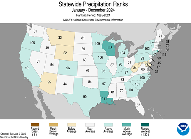
The precipitation throughout 2024 was above-average throughout much of the upper Midwest. A majority of Wisconsin saw above average precipitation. To read the complete assessment of the U.S. Climate in 2024, please visit the National Center for Environmental Information through NOAA.
Although much of the United States experienced higher than average precipitation, there was still drought present throughout 2024. The year began at 33% of the U.S. in drought, with a low at 12% in June. The drought peaked at the end of October at 54% of the country in drought, including the great lakes region.
Photo Credit: NOAA
NFIP Extended To March 14, 2025
The National Flood Insurance Program (NFIP) has now had over 30 extensions since the last five-year extension that expired Sept. 30, 2017. The latest extension was set to expire Dec. 20, 2024, but the NFIP’s authorization was extended to March 14, 2025.
FEMA's Congressional Reauthorization for the NFIP page should have the latest updates. FEMA reports that they and Congress have never failed to honor the flood insurance contracts in place with NFIP policyholders. Should the NFIP’s authorization lapse, FEMA would still have the authority to ensure the payment of valid flood claims with available funds.
Should the authorization lapse, however, FEMA would stop selling and renewing policies for millions of properties in communities across the nation. Nationwide, the National Association of Realtors estimated in 2017 that a lapse might impact approximately 40,000 home sale closings per month.
RiskMAP is a FEMA-led process, facilitated by the Wisconsin DNR and used to update or create flood insurance rate maps (FIRMs). The FIRMs and other datasets created during this process are used to help move communities toward flood resiliency. Flood risk datasets work alongside regulatory products to provide flood risk information and support the community's floodplain management and hazard mitigation strategies. DNR Floodplain engineers and GIS mapping staff often play a crucial role in the development of RiskMAP projects. To see a list of current RiskMAP Projects, visit the website.
There are several key meetings and milestones that occur throughout the RiskMAP project lifecycle, which can take 3-5 years to complete.
-
Discovery Period – This is the first phase of the RiskMAP lifecycle with the goal of identifying risk. FEMA, state and local leaders will collect and review flood risk data and use this information to gather a complete picture of a community’s flood risk. Discovery helps determine whether a RiskMAP project is needed and what the scope of the project will be. Community officials within the project area play a critical role, as they provide feedback and details on specific flood risk challenges and concerns. This phase happens in the first year of the project.
-
Project Kickoff Meeting – This meeting introduces communities to project specifics and scope of work prior to data development. Desired input from community officials is discussed.
-
Flood Risk Review (FRR) And Resilience Meetings – These meetings are part of the analysis and mapping phase after data development has been completed. The purpose of the FRR meeting is to provide an overview of the engineering analyses, present draft work maps and datas, and collect feedback from community officials. During the Resilience meeting, the project team presents additional non-regulatory products, which can be used to aid in developing mitigation strategies and contribute to a better overall understanding of flood risk. This can help communities plan for the future by discussing factors that contribute to flooding in project areas, as well as identifying ways to reduce the risk. Following the completion of draft mapping, it can take approximately 6-12 months to reach the preliminary map status.
-
Preliminary Flood Map Release – Once preliminary products have been released, they can be viewed at FEMAs Map Service Center by selecting the appropriate county and community from the jurisdiction menu. After preliminary release, there’s typically another 12-18 months before the maps will reach effective status.
-
Consultation Coordination Officer (CCO) Meeting And Public Open House – The CCO meeting is sponsored by FEMA with presentations by the state of Wisconsin floodplain mapping staff. The purpose is to present the preliminary FIRMs and FIS report and gather feedback on the products from local officials. Following the CCO meeting, a Public Open House provides citizens the opportunity to view maps, ask questions, learn about local flood risks and resources available to reduce risk. Local communities are urged to promote the Public Open House so citizens are aware of the proposed map changes. The CCO meeting and Open House are typically scheduled a month or two after the preliminary map release.
-
90-Day Comment And Appeal Period – Following two public notices in a local newspaper, this 90-day period allows the opportunity for comments and appeals to be submitted on the updated maps. Appeals must meet standard requirements, and any submissions should be routed through community zoning administrators prior to review.
Additional details on the steps throughout the RiskMap process are available on FEMA’s website.
Letter of Final Determination (LFD) and effective date are milestones in a flood risk project. The Letter of Final Determination is sent to the community executive stating that the final notice of flood hazard determinations will be published in the Federal Register and new or updated flood insurance rate maps will soon reach effective status. The receipt of this letter starts the 6-month adoption phase of the process. This is where communities need to update their floodplain ordinances to incorporate the updated maps and FIS, by the federal effective date to remain in good standing in the National Flood Insurance Program (NFIP). Currently, most communities also update their floodplain zoning ordinance language so that the current regulations meet state and federal minimum standards. DNR floodplain staff can set up a draft floodplain zoning ordinance for the community to review. Our assistance is provided to communities free of charge. If you are interested, please get in touch with DNR at DNRFloodplain@Wisconsin.gov.
The table below details the timing of the Risk Mapping Meetings and anticipated Letter of Final Determination start dates for upcoming projects.
Project
|
Discovery
|
Project Kickoff Meeting
|
Flood Risk Review And Resilience Meeting
|
|
CCO Meeting/Open House
|
90-Day Appeal Period
|
LFD Start
|
|
Washington County
|
May 16, 2013 (Milwaukee Watershed)
|
N/A
|
Aug. 28, 2019 (Milwaukee Watershed)
|
March 20, 2024
|
May 2, 2024
|
Sept. 27-Dec. 26, 2024
|
Sept. 17, 2025*
|
|
Douglas County
|
N/A
|
March 20, 2020
|
Jan. 25, 2023
|
Dec. 2, 2024
|
Jan. 23, 2025
|
TBD
|
TBD
|
|
Langlade County
|
N/A
|
April 29, 2020
|
April 14, 2023
|
April 30, 2024
|
May 29, 2024
|
Sept. 13-Dec. 12, 2024
|
Aug. 8, 2025*
|
|
Dane County (Pennito Creek PMR)
|
N/A
|
N/A
|
N/A
|
July 11, 2023
|
Aug. 29, 2023
|
Nov. 3, 2023-Feb. 1, 2024
|
Oct. 9, 2024
|
|
Richland County
|
March 26, 2018 (Kickapoo Watershed)
|
Jan. 13, 2022
|
Jan. 11, 2024 (Kickapoo Watershed)
|
Jan. 31, 2025
|
March 18, 2025
|
TBD
|
TBD
|
* – Dates are subject to change
N/A – projects with mapping needs previously identified or projects initiated by communities may follow a variation of the typical RiskMAP project timeline
|