DNR Parks And Recreation News
What’s Happening In Wisconsin's State Parks,
Trails, Forests And Recreation Areas
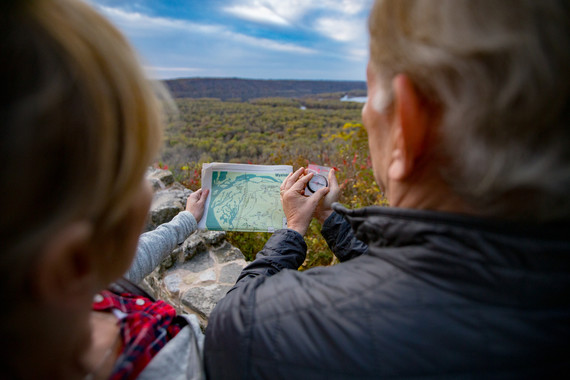 Photo Credit: Travel Wisconsin
Need Holiday Gift Ideas? Get Them The Gift Of Wisconsin's Outdoors
Wisconsin state park and forest annual admission stickers make a great gift for everyone on your list for any occasion. Purchase them for friends and family beginning this Friday, Nov. 25.
The 2023 stickers and passes for admission to parks, forests, recreation areas and trails are valid from the date of purchase through Dec. 31, 2023.
An annual sticker or daily admission pass is required on all motor vehicles visiting state parks and recreation areas. Some state forest and trail parking areas also require the annual sticker or daily admission pass.
We recommend purchasing stickers online or by phone by Friday, Dec. 9 to receive them before the holidays.
An admission sticker costs $28 for Wisconsin residents or $38 for non-residents. If there is more than one vehicle registered to the same household, additional state park and forest stickers are available for $15.50 for residents and $20.50 for non-residents. A senior citizen annual sticker for $13 is available for Wisconsin residents 65 years of age and older. Annual trail passes are $25 for residents and non-residents.
Who needs a trail pass? State trail passes are required for all people aged 16 or older biking, in-line skating, horseback riding, cross-country skiing or off-highway motorcycling on specific state trails. A state trail pass is not required for walking or hiking.
Resident and non-resident annual admission stickers are available online and at individual state park and forest properties via drive-up window service, self-registration kiosks or over the phone. State trail passes are available only at individual properties or licensed vendors.
In charge of coordinating those employee gifts at work? Change it up this year from the normal company-branded mug and get them the gift of the outdoors. If you'd like to purchase a bulk order of 20 or more annual admission stickers on behalf of yourself or your organization, fill out this questionnaire and our staff will assist with the order.
Learn more about Wisconsin's state park and forest vehicle admission stickers.
Photo Credit: Brookfield East High School student Brooke Salomone
|

Opt Outside
Join the businesses and people who are choosing to "Opt Outside" this Black Friday instead of going shopping and get out to enjoy the last days of Wisconsin fall.
Started by outdoor gear company REI in 2015, the idea behind Opt Outside is to "recognize the value of time spent outside and the impacts it has on our well-being." This resonates with the DNR and our OutWiGo initiative encouraging everyone to improve their overall health and wellness by getting out and active outdoors.
Call friends or family and plan to find a park to explore on Nov. 25. If you need some inspiration, check out our list of hidden gems.
Photo Credit: Travel Wisconsin
|
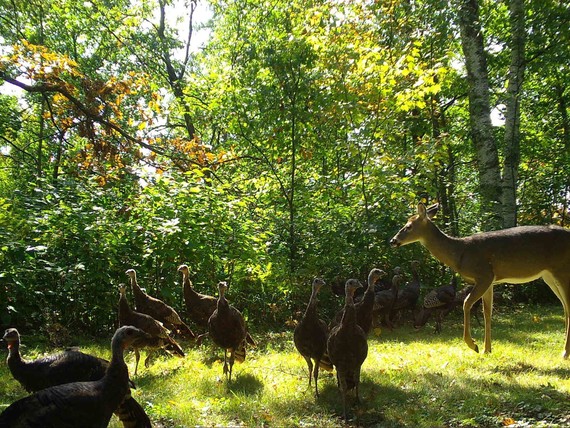 Wild turkeys are native to North America. Domesticated turkeys, like what you'll find at a Thanksgiving table, are bred to be meatier than their foraging kin. Here, turkeys and deer co-habitat. Photo Credit: Wisconsin DNR
Did you know...
- The wild turkey is the only type of poultry native to North America and is the ancestor of the domesticated turkey. Despite being overhunted and pushed out by development in the 1880s, we now estimate there are 350,000 wild turkeys that live in Wisconsin today.
- Turkeys can run 18 miles per hour on foot and up to 50 miles per hour in flight.
- Turkey droppings tell a bird’s sex and age. Male droppings are j-shaped; female droppings are spiral-shaped. The larger the diameter, the older the bird.
- Wild turkeys live year-round in open forests with interspersed clearings in 49 states.
Learn more about wild turkeys from Wisconsin Pollinators and the U.S. Fish and Wildlife Service.
Snapshot Wisconsin is a partnership to monitor wildlife year-round using a statewide network of trail cameras. The project provides data needed for wildlife management decision support. It is also a unique opportunity for individuals, families and students to get involved in monitoring the state’s valuable natural resources.
Learn more about how you can participate in Snapshot Wisconsin's citizen science project.
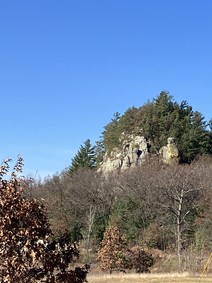
Mill Bluff State Park
Tucked away off of Interstate 90/94 outside of Camp Douglas, Mill Bluff State Park is part of the Ice Age National Scientific Reserve. It offers a spectacular view of picturesque rock formations and a bluff that is perfect for stretching your legs during a long car ride.
In the mid-1930s, the Work Progress Administration built 223 stone steps that lead to the top of Mill Bluff, where an observation deck on the north end offers an excellent view of the park and the surrounding area.
The park features a number of interesting rock formations including mesas, buttes and pinnacles that range from 80 to over 200 feet tall. Although this park is in the Driftless region that Wisconsin's glaciers didn't touch, these geologic features are partially the result of the last stage of glaciation.
During this glacial advance, the Wisconsin River was plugged near Wisconsin Dells. The river spread out to form glacial Lake Wisconsin, covering most of what today are Adams and Juneau counties, including the Mill Bluff area. The lake level meant that some of the mesas and buttes stood as islands, while others were submerged. Waves on the lake hastened the erosion of the sides of the rock forms. The unique flat-topped, cliff-sided rock structures are capped by layers of somewhat more resistant sandstone, which tends to break off in vertical fragments.
These, and more, interesting glacial features are protected in Mill Bluff State Park. Because of the uniqueness of this park and of the delicate sandstone structures of the buttes, climbing on or defacing the bluffs is strictly prohibited.
Year-round hiking is available at Mill Bluff. Hunting and trapping are allowed and, in the summer, swimming is available. While Mill Bluff is not staffed during the winter, the park is still open. Visitors can hike, snowshoe or cross-country ski on marked trail systems. Trails are not groomed or maintained for winter use. Although there is no biking at Mill Bluff, the county's Omaha Trail connects to the park and to the Elroy-Sparta and 400 state trails.
Learn more about Mill Bluff State Park in Juneau County.
Photo Credit: Andy Haffele, Wisconsin DNR
|
Before there was Governor Nelson State Park, the land supported agriculture and summer vacations. Join Don Sanford, author of On Fourth Lake: A Social History of Lake Mendota, for a trip back in time when cows grazed the fields along Highway M and kids sang around the campfires on the shore of Lake Mendota.
This event will be held at the Westport Town Hall at 5387 Mary Lake Road in Waunakee. The event is free and open to the public.
|
Where did you #OptOutside this Thanksgiving weekend?
Let us know on social media using #OptOutside and #OutWiGo!
Then, explore the hashtags to see how others found their adventure.
|