September 24, 2021
Dear Friends and Neighbors,
In accordance with state laws, the independent and bipartisan Washington State Redistricting Commission redraws state legislative and congressional district maps every 10 years. Earlier this week, the commission released four proposed options for state legislative districts and is expected to release federal congressional district proposals in the coming weeks. The 12th District and Washington’s 48 other legislative districts have had specific boundaries since 2012. The borders for these districts, as well as Washington’s congressional districts, will change in 2022 after the state’s redistricting process is completed by the commission by November 15. The Legislature is expected to provide final approval of the maps during the 2022 legislative session.
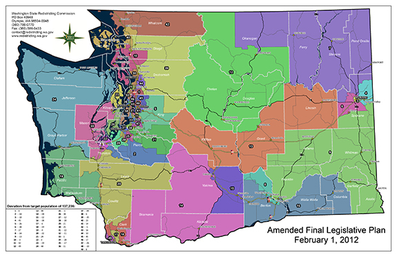 The Redistricting Commission will be rebalancing the state legislative districts to ensure each district represents approximately the same population. Our current 12th District is one of the largest districts in our state geographically and includes Chelan and Douglas counties and portions of Grant and Okanogan counties.
How Washington’s redistricting process works
The redistricting process occurs after the completion of the national census, which is taken every 10 years, most recently in 2020. Congressional district lines have been drawn by the Redistricting Commission since 1983 and legislative district boundaries since 1991. This commission comprises five members. Four are appointed by the leaders of each of the four major caucuses. The four appointed commissioners then appoint a fifth, nonvoting, chairperson. Enactment of new redistricting maps for Washington requires bipartisan approval. If at least three of the four Redistricting Commission members cannot agree on a map that is fair to all, responsibility for drawing the lines is turned over to the Washington Supreme Court. Our state’s bipartisan redistricting system requires cooperation. It isn’t surprising that Washington’s redistricting process is admired by other states seeking to move away from an approach in which one party controls the final result.
Voters created state’s Redistricting Commission
For many years, the Legislature was in charge of redistricting, but many had grown angry and frustrated with how partisan and time-consuming this approach had become. By the 1980s, Washingtonians sought change. In 1983, Washington voters passed Senate Joint Resolution 103, an amendment to our state constitution that created our state’s independent Redistricting Commission. Over the past decade, several other states have revamped their redistricting process to reduce the chance of partisan politics and “gerrymandering,” a term describing districts with bizarrely drawn boundaries. I’m encouraged to know other states have followed our state’s lead in creating independent commissions to draw up legislative and congressional district maps, with just minimal political manipulation involved.
Proposed state legislative district maps
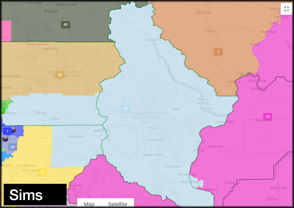
Redistricting Commissioners Joe Fain, Brady Pinero Walkinshaw, April Sims, and Paul Graves have each proposed new state legislative and congressional maps. The nonvoting chair of the commission is Sarah Augustine. Approval of final maps requires at least three votes of the four voting members. While it is possible that one of these proposals could be adopted, it is likely that the final approved maps will be a new variation based on public comments received. Below is my analysis of each proposal.
-
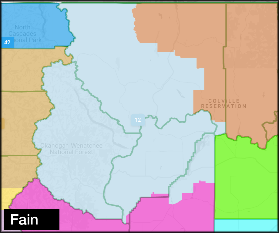
Commissioner Fain’s proposal: I support this proposal. It includes Chelan and Douglas counties and portions of Okanogan and Grant counties. This plan keeps Chelan and Douglas counties together while expanding some of Okanogan County, a county with an important history within the 12th District. To review the map of this proposal, click here.
-
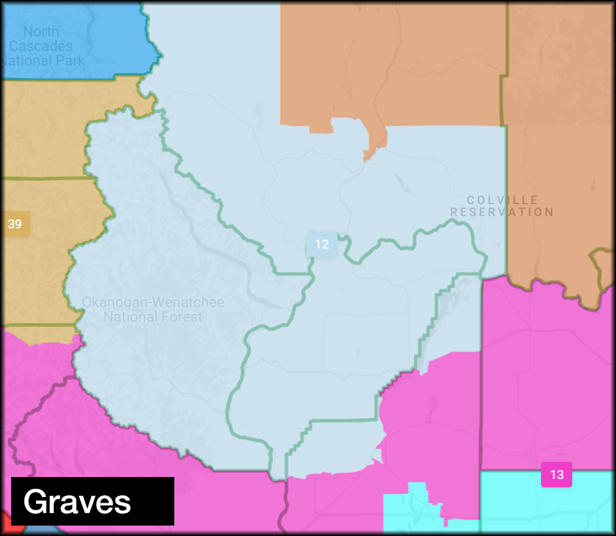
Commissioner Graves’ proposal: I also support this proposal, which is similar to our current district. It includes much of the same boundaries proposed by Commissioner Fain. This plan keeps Chelan and Douglas counties together while expanding to some areas of Okanogan County, a county I am familiar with through my service. These longstanding relationships with key communities and stakeholders – including a collection of historical knowledge – is important to these areas as they are impacted by many state policies. To review the map of this proposal, click here.
-
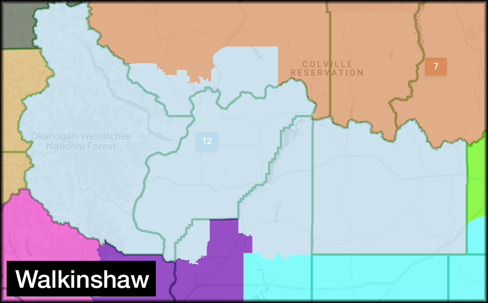
Commissioner Walkinshaw’s proposal: While not a preferred choice, this map is reasonable and the boundaries proposed are accessible. It keeps Chelan and Douglas counties together but would transition from a North Central Washington district to more of a Central Washington district, adding Lincoln County. While it contemplates the unfortunate loss of many key Okanogan County communities and stakeholders, the characteristics of the proposed area are consistent with many existing areas in the 12th To review the map of this proposal, click here.
-
Commissioner Sims’ proposal: I do not support the 12th District boundaries in this proposal. The district would be oddly shaped, difficult to access, eliminates Okanogan County, and splinters Chelan and Douglas counties. The western portion of the proposed 12th District would be difficult to access and likely limit interactions with many constituents. These boundaries do not seem realistic or workable. To review the map of this proposal, click here.
Please comment on state legislative district maps
The fortunate part of Washington’s redistricting process is that it includes ample opportunity for public comment. I strongly encourage you to offer individual comments as well as formal comments on official letterhead. (Please be respectful and thoughtful in your comments.)
Keep Chelan and Douglas counties together: One of the most important considerations for state legislative maps is to keep Chelan and Douglas counties together given our “communities of interest,” which is key for the commission. This seems particularly true in consideration of the Chelan-Douglas Health District, Chelan-Douglas Regional Port Authority, Chelan-Douglas Transportation Council, Chelan-Douglas Land Trust, Wenatchee Valley Chamber of Commerce, Link Transit, and many other agencies that partner within Chelan and Douglas counties.
Maintain Okanogan County communities: Another important consideration is maintaining key communities and stakeholders with longstanding relationships within the 12th District. The Okanogan County portion of the district involves many key communities and stakeholders with unique interests. The 12th District legislators have built up an appreciation and historical knowledge of these areas that are impacted by many state policies. Having continuity of service to these communities – rather than a less familiar, new legislator – is important to those areas. Two of the proposals (Walkinshaw and Sims) would eliminate these communities from the 12th District, if one of those proposals was approved.
To offer your comments to the Washington State Redistricting Commission, click Submit Letters and Public Comment or send comments directly to Comment@redistricting.wa.gov.
History of 12th District borders
In the early 1930s, the 12th District was moved from southeastern Washington to its present location in North Central Washington. All of Chelan County has been within the 12th District since then. In 1965, the 12th District included all of Chelan and Douglas counties. By 1972, the western half of Okanogan County, including Winthrop and Brewster, was added to the 12th District, as was the northern part of Grant County. The northern portion of Kittitas County was part of the 12th for 30 years until the present boundaries were redrawn in 2012 – a shift that also picked up more of the southeastern portion of Okanogan County and part of Grant County. Regardless of any shifting boundaries for the next 10 years, my hope is that Chelan and Douglas counties and many Okanogan County communities can remain together in one district.
Thank you for the opportunity to serve as your state senator.
Sincerely,

Brad Hawkins
State Senator
Brad Hawkins
12th Legislative District
E-mail:
brad.hawkins@leg.wa.gov
Website: senatorbradhawkins.org
107 Newhouse Building
- P.O. Box 40412 | Olympia, WA 98504-0412
(360) 786-7622 or Toll-free: (800) 562-6000
|