|
Connectivity -- Safety -- Opportunity -- Participation -- Partnership
--------------------
Vulnerable Road Users Assessment Report Shows Patterns in Crashes Affecting People Walking and Bicycling
Every time we use local and state roadways in Washington state, we accept some degree of risk. Traffic crashes have killed or seriously injured our neighbors at an increasing rate over the past decade, with 750 people dying on Washington public roads in 2022 alone. And while more of us champion the human and environmental benefits of walking and rolling, cyclist and pedestrian deaths increased 72.5% over the past decade.
But Washington state transportation leaders believe the only acceptable number of traffic deaths and serious injuries is zero -- a sentiment enshrined in policy as Target Zero – and that pedestrians and cyclists receive equitable resources in service of safer mobility, as evident in the Safe System Approach. The Safe System Approach focuses on proactive countermeasures to reduce the likelihood and severity of crashes when designing and operating our streets and highways. WSDOT recently completed an updated Vulnerable Road User Safety Assessment as part of its Highway Safety Improvement Program to better identify factors that make vulnerable users -- people walking, rolling and biking -- more exposed to crashes, at greater frequencies and higher crash severities, and to propose tailored solutions that help us all make it home safely no matter how we get around.
The solutions are bold and require everyone to play a role – but doing things that make people walking and biking safer, make the rest of us safer, too.
What the Assessment Found
In reviewing a decade’s worth of crash data on all public roads as well as the state network, involving either drivers and cyclists or drivers and pedestrians, WSDOT found for streets overall:
- There is a relationship between race, economic status and age with where traffic crashes happen and to whom. Drivers are more likely to kill or seriously injure people walking, rolling and biking in communities that are historically overburdened, in persistent poverty or experiencing other forms of environmental health disparities. The most recent fatality crash data, analyzed through a custom VRU Diversity, Equity and Inclusion rubric, show overrepresentation between racial demographics, too: Cyclists and pedestrians who identify as Black, American Indian or Alaska Native, or Two or More Races are more likely to be killed in traffic crashes than people who identify as White or Asian.
- Time of day matters. Drivers are more likely to kill or seriously injure people in the late afternoon and evening, especially during rush hour when more people are driving and crossing streets by bike or on foot. Crashes peak in the morning during rush hour as well.
- Older people are especially vulnerable: The age group experiencing the most deaths and serious injuries are those 65 and older, with people aged 30 to 34 the next most affected.
- Most crashes happen on urban roads, especially arterials managed by cities. Crashes with pedestrians and cyclists happen where most pedestrians and cyclists are, and the greatest densities of pedestrians and cyclists are on urban streets with posted speeds at or lower than 45mph.
- The most crashes per mile occur between 25mph and 45mph, especially with more than two lanes. The greatest proportion of crashes per mile happen when posted speeds are 30mph. This may seem relatively slow to drivers, but increasing vehicle speed even a small amount exponentially increases the chances that a crash becomes seriously injurious or deadly – and there’s a bigger difference between speeding 35mph on a 30mph posted street than speeding 70mph on a 65mph posted highway.
- When it comes to state highways, WSDOT was able to identify that most crashes happen within a mile of schools and transit stops – the places where many people, especially younger ones, expect to be on foot, and often where there aren’t facilities for people to easily reach their destinations.
What’s Next
The data support the need for the Complete Streets requirement and Safe System Approach in pursuing our stated goal of Target Zero, or zero fatal or severe crashes on our transportation system. These policies aim to improve comfort and access to all roads for all people, while proactively reducing the likelihood of serious or fatal crashes on those roads, respectively.
WSDOT views safety performance as a measure of how many people are either driving, walking, biking and rolling, and therefore present to be in a crash; how likely they will be involved in a crash, given the road and user behaviors; and how severe those crashes will be given the size, speed, and mass of a driver’s vehicle or person they strike. When developing road treatments that reduce exposure, likelihood or severity for one method of travel, we must explicitly consider how these change safety outcomes for all users. In many cases, reducing crash potential for our most vulnerable users benefits road safety outcomes for drivers and vehicle occupants as well.
WSDOT aims to screen and prioritize potential project locations to address vulnerable road user crashes before they happen. This data support WSDOT in prioritizing screening on major urban and suburban arterials with two or more lanes, with posted speeds up to 45mph, and near schools and transit stops. It also suggests WSDOT should prioritize areas with higher volumes of people older than 65, whom drivers kill disproportionately relative to other age groups, and communities overburdened by socioeconomic inequities.
The assessment concludes with both a list of treatments, or safety countermeasures, centering vulnerable road users; and a summary of proposed actions that speak to these treatments and overall approach to understanding safety. Any government that aspires to receive funding from WSDOT’s Highway Safety Improvement Program will want to note these actions and list of treatments -- which include reduced speeds, separated facilities, and other things that give vulnerable road users space, options and visibility while making decisions. The report further lends support to WSDOT increasing partnerships with local agencies and improving our ability to expand and deepen data collection for serious and fatal crashes.
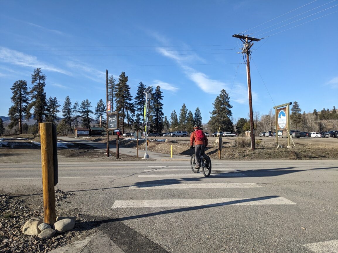 A person cycling crosses a street at a crosswalk on a sunny day in Winthrop, Washington. (Briana Weisgerber/WSDOT)
New Active Transportation Programs Design Guide Available
The Active Transportation Programs Design Guide is a tool that provides the best practices for implementing treatments that create safer conditions for people who walk, bike and roll on local roads. Local agencies and Tribes can use the guide as a resource when developing projects for WSDOT Pedestrian/Bicyclist and Safe Routes to School grant programs’ application cycles. For each treatment, the guide contains descriptions and, if applicable, drawings that can assist applicants in considering the dimensional elements of a design. It aims to define these treatments for the funding programs, but WSDOT invites local agencies, Tribes and partners to use the tool as they see fit.
WSDOT wanted to provide local and Tribal government partners with guidance for local roads as to proven ways to improve safety and comfort of the infrastructure people walking and rolling use in our state. The guide draws on the most current and best practice information from across the United States while also considering the needs and experiences of local agencies and Tribes within Washington state. WSDOT staff, funding partners, counties, cities and MPOs representing the active transportation needs of our state across rural, suburban and urban communities reviewed and helped shape the guide over the past year.
Agencies are already telling us they will use the guide to inform project elements within comprehensive plans and transportation system plans. Consultants have offered it as a tool for their clients planning and designing active transportation projects in Washington state. We look forward to hearing more from anyone using the guide about how they’re applying it to improve walking and bicycling for Washington’s residents.
Check out the guide on WSDOT’s website and be sure to visit the Pedestrian & Bicycle Program and Safe Routes to School webpages to learn more about our grant offerings.
We add new trainings as we find them, so the list changes with every issue. Some of these offer continuing education credits. All times are shown in Pacific time zone.
All webinars listed are FREE unless a price is noted. All items are webinars unless a location is noted.
March
April
- April 3, 11:00am: People over Parking: Advancing Walkability through Parking Reform. (America Walks)
- April 7 – 9: Lifesavers Conference on Roadway Safety (Lifesavers), Denver, CO
- April 10: 13th Annual Celebrating Women Who Move the Nation (Conference of Minority Transportation Officials) Washington, DC
- April 11: Adaptive Trail Mobility Equipment and Programming 101. (American Trails, donations appreciated.)
- April 13 – 16: National Planning Conference (American Planning Association) Minneapolis, MN and May 8 - 10, 2024, Online
- April 15-17: 2024 National Tribal Leaders Climate Summit (ATNI)
- April 17, 12:00-1:00pm: Best Practices: Emergency Vehicle Access for Bicycle/Pedestrian Friendly Streets. (APBP)
- April 17, 12:00pm to 1:00pm: Webinar: Marginalized Populations’ Access to Transit (NITC)
- April 25, 10:00-11:00am: Community Driven: How Engagement Guides the Vision and Planning of a Community Wide Trail Network (American Trails, donations appreciated.)
- April 25-26: Open The Paths 2024: An Open Data and Transportation Equity Conference (University of Washington)
- April 27: Rails-to-Trails Conservancy's Celebrate Trails Day (Rails-to-Trails Conservancy)
Save the Date
-
WSDOT Pedestrian/Bicyclist Program and Safe Routes to School Program Calls for Projects: Local agency and Tribal government partners are invited to apply for grant funding facilitating the design and construction of infrastructure and programs enhancing safety and comfort for people who walk and roll. Deadlines: Midnight on May 31 and June 7, 2024, for PBP and SRTS respectively.
- FHWA announces 2024 Safe Streets for All funding opportunity. Multiple due dates, starting April 4, 2024.
- Urban Cycling Institute Scholarship Program (UCI): Velo-City World Cycling Summit 2024 Scholarship. Deadline: March 24.
- USDOT Rural and Tribal Assistance Pilot Program : will be offering a funding opportunity up to $360,000. Applications can be submitted in an ongoing manner, and will be considered on a rolling basis; grants will be made on a first-come, first-served basis. Eligible applicants (a local government located outside of an urbanized area with a population of more than 150,000 residents; a state government seeking to advance a project for an area located outside of an urbanized area with a population of more than 150,000 residents; a federally recognized Indian Tribe; or the Department of Hawaiian Home Lands) are encouraged to apply as early as possible – opportunity opened August 14, 2023.
- Funding specifically for active transportation is coming soon from FHWA – new Active Transportation Infrastructure Investment Program ($45 million in Federal Fiscal Year 2023) will support planning, designing, and constructing active transportation facilities, particularly to integrate with and improve access to public transportation.
Keep track of all of the USDOT’s discretionary funding opportunities at the DOT Discretionary Grants Dashboard. Also, a full listing of pedestrian- and bicycle-related federal funding programs is available through FHWA.
Have any funding opportunities people should know about? Send them to WSDOTActive@wsdot.wa.gov.
Call for Papers
Call for Webinar Presenters, 2024 and Beyond
-
Provide your topic ideas for the Advancing Trails Webinar Series. If any details requested are not known, they suggest that you complete the form to the best of your ability with your interest as they want to hear from you. Should your topic be selected, they are happy to save a webinar date and can obtain details to promote the webinar at a later date once available. All webinars are held on a Thursday starting at 10:00am Pacific. (American Trails)
Call for Abstracts/Session Proposals
If you read this far, thank you! You're finding something of value here and you know someone else who should receive this kind of news. Forward WSDOT Walk and Roll to others and share the subscription link on social media (tag it #WSDOTactive). Click to edit this placeholder text.
Hannah Weinberger
Communication Lead, WSDOT Active Transportation Division
hannah.weinberger@wsdot.wa.gov
|