What's to Come and What You Missed
Welcome to the many new subscribers that have joined us since the new year! We're glad you're here! If you know someone who would like to learn about this study, please forward them this email and encourage them to subscribe.
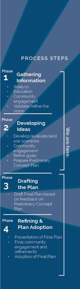
Arlington’s planning team is developing a Preliminary Concept Plan (PCP) for the Langston Boulevard corridor. The PCP will describe planning goals, policies, and recommendations for private and public investment within the study area for review by the community and the County.
The PCP will be based on previously shared planning ideas and input from the community. There will be opportunities for additional public feedback, and the plan will be updated again before review and adoption.
This week, we are kicking off a newsletter series about each of the study’s key planning elements. In each newsletter, we will outline one key planning element goal and what has been shared previously on that topic.
The Key Planning Elements are:
-
Land Use
-
Economic Vitality
-
Housing
-
Building Form
-
Transportation, Connectivity, and Urban Design
-
Public Schools, Facilities, and Spaces
-
Historic and Cultural Resources
-
Sustainability and Resilience
This week, our newsletter is talking about LAND USE.
|
Land Use
Goal: Transform Langston Boulevard into a main street corridor.
Benefits of Land Use Changes
A top priority in the community is to transform Langston Boulevard into a Green Main Street. To become a Green Main Street, a more mixed-use land use pattern with higher density development and more residents in walkable destinations is needed. New density makes the transformation economically viable for the private sector and has several co-benefits that improve quality of life along Langston Boulevard and adjoining neighborhoods.
Land use changes will provide more housing choice and affordability, walk-in customers, open space, streetscape and safety improvements, increased bicycle and transit ridership, an enhanced built environment, awareness of history and culture through public art, reduced energy usage and emissions, and reduced flooding and improved water quality. These changes will likely take decades, but the plan for Langston Boulevard will provide guidance when property owners are ready to take action.
Have you weighed in on the corridor-wide objectives or neighborhood improvements and benefits that are most important to you?
2016 Visioning Study Report + Land Use
Building on the initial grassroots community engagement, the County conducted a community visioning process in 2015. This process helped determine the long-term vision for Langston Boulevard that calls for it to become a walkable main street with neighborhood activity centers between Rosslyn and East Falls Church. The 2016 visioning report served as a starting point for aspirational goals and more focused community discussions around the key planning elements.
The land use recommendations in the report include:
- Establishing the location and boundary of multiple mixed-use centers or hubs of activity;
- Identifying where mixed-use is desired or required;
- Defining centers, edges, and sensitive transition areas in each node;
- Establishing great destinations to enhance walkability;
- Creating opportunities for increased residential, office, and commercial uses; and
- Identifying potential redevelopment sites.
Existing Conditions Analysis Report + Land Use
The Existing Conditions Analysis Report built on community conversations, open house events, focus groups, and a walking tour. The report examines the existing land uses in the study area and identifies potential opportunities and constraints for supporting the goal of transforming the corridor into a Green Main Street. This report determined potential areas for change, potential types of change, and where transitions in use will be most important.
The report showed that the core study area is:
- primarily auto-dominated and characterized by low-rise commercial uses with pockets of residential
- missing mixed-use development that supports a walkable, “main street” environment
- limited by the current land use vision and zoning framework
The report also shared that the planning process would be testing the potential for different types of development, appropriate levels of density/building height, and the locations of uses, while also identifying any land use and zoning changes that will be needed.
Neighborhood Inspiration Report + Land Use
The Neighborhood Inspiration Report highlights what we have and appreciate in our neighborhoods today and community aspirations for what they can become. This analysis established a strong foundation for the land use scenarios that were shared with the community in April 2021. The community identified the following priority actions:
Area 1: Arlington East Falls Church
- Revise zoning to:
- allow for greater variety of housing types and
- promote sustainability while retaining green spaces and adding full canopy trees.
- Increase density in the East Falls Church (EFC) Area Plan
- Redevelop the Metro parking lot according to EFC Area Plan with west entrance to station
Area 2: John M. Langston, Yorktown, Tara Leeway Heights, Leeway Overlee
- Reexamine lot coverage
- Prioritize mixed-use development instead of townhouses to preserve strong commercial core
- Develop the four corners of the Langston Boulevard and Harrison Street intersection
- Reduce gas stations and banks
- Focus on walkability and transit
- Revise zoning to increase density and allow for greater diversity of housing
- Preserve green space and parks and find new park space
Area 3: Waverly Hills, Donaldson Run, Old Dominion, Glebewood, Waycroft Woodlawn
- Increase flexibility in design and zoning regulations (including parking) and streamline review process to make it easier to build
- Integrate stormwater management into all future plans and designs
- Consolidate parcels for walkability
Area 4: Cherrydale + Maywood
- Identify and preserve locations for schools to accommodate the potential for increased population
Area 5: North Highlands + Lyon Village
- Conduct analysis for potential zoning changes
- Consider rezoning
- Review public facility needs and co-location of uses
Land Use Scenario Analysis
In April 2021, the Land Use Scenario Analysis, which included preliminary ideas for land use mixes and intensities, was shared with the community. Through several public feedback engagements, the community expressed support for the following ideas:
- More residential development if committed affordable units are required as part of redevelopment (except in Area 2, where there is concern with adding density)
- Mixed-use development
- Flexibility in ground floor uses
The community also reported several concerns, including commercial or mixed-use development that encroaches on existing low-density residential areas; consolidating Langston Blvd frontage properties with adjacent residential properties to achieve mixed-use development; planning for missing middle housing forms with greater density than one-family at the edges of the corridor; loss of existing Market-Rate Affordable Units due to redevelopment; addition of affordable housing in certain neighborhoods; changes in property values; changes in character; and loss of small businesses.
Based on community feedback, the planning team will:
- Focus proposed redevelopment at key nodes and intersections
- Revisit proposed building heights to strike a balance between feasible development & community input
- Re-consider which residential edges immediately adjacent to commercial areas may be needed to facilitate mixed-use, affordable housing and/or other improvements along Langston Blvd frontage
- Analyze missing middle types and forms through the Missing Middle Housing Study
- This is no longer a specific component of PLB.
- Refine the land use scenarios to develop a Preliminary Concept Plan for further review and community discussion
|