|
For the Week of June 19, 2022

Weekly Hydro Ship Activity Report
Welcome to NOAA's Weekly Hydrographic Ship Activity Report! We hope you enjoy this reader-friendly layout for our weekly report as we update you on the progress of our NOAA-ship and contractor-run surveys. Please continue to direct your correspondences to progress.sketches@noaa.gov.
Highlights of this edition
- NOAA Ship Thomas Jefferson got underway from the Port of Cleveland and conducted survey operations on OPR-W386-TJ-22 Approaches to Cleveland, OH.
- DEA continued hydrographic operations in OPR-K356-KR-22 Approaches to Calcasieu, LA.
NOAA Ships
Ferdinand R. Hassler
OPR-F364-FH-22 Onslow Bay, NC
Recap
- NOAA Ship Ferdinand R. Hassler was alongside for maintenance and crew rest at Poseidon Wharf in Port Canaveral, FL.
|
|
|
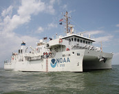 |
- NOAA Ship Ferdinand R. Hassler prepares to go underway on 27JUN2022 to transit towards OPR-F364-FH-22 Onslow Bay, NC.
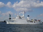
THOMAS JEFFERSON
OPR-W386-TJ-22 Approaches to Cleveland, OH
Recap
- NOAA Ship Thomas Jefferson got underway from the Port of Cleveland on 6/20 and conducted survey operations acquiring on sheets H13609, H13616, and H13617.
|
|
|
 |
Looking Forward
- NOAA Ship Thomas Jefferson will be conducting survey operations on OPR-W386-TJ-22 acquiring on sheets H13609, H13615, and H13617.
- The ship will be arriving in Cleveland, OH for its regularly scheduled inport on 7/01.
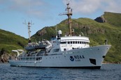
FAIRWEATHER
OPR-P335-FA-22 South Coast of Kodiak Island, AK
Recap
- NOAA Ship Fairweather was alongside Marine Operations Center - Pacific (MOC-P) in Newport, OR.
|
|
|
 |
- NOAA Ship Fairweather will be alongside until its next scheduled departure on 07JUL2022.
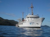
RAINIER
OPR-T381-RA-22 Mariana Islands
Recap
- NOAA Ship Rainier worked on 5 sheets while conducing dive operations moving north through CNMI.
|
|
|
 |
- On 6/19, the ship was at anchor in Pagan for dive operations. The ship surveyed during its transit to Maug in sheets H13584 (Sarigan and Zelandia Bank) and H13586 (Anatahan).
- On 6/20, the ship recovered the HARP buoy ~14nm offshore of Pagan and surveyed H13582 (Agrihan).
- The ship arrived in Maug on 6/21, re-surveyed some lines with SVP issues, recovered the tide buoy, and anchored.
- On the evening of 6/22, the ship got underway for sheet H13580 (Farallon de Pajaros) and surveyed overnight.
- The ship and HSL completed H13580 on 6/23.
- On 6/24, the ship re-surveyed lines with SVP issues in Maug before anchoring.
- On 6/25, the ship was anchored in Maug for diving operations.
Looking Forward
- While in Maug for 6/26 through 6/28, NOAA Ship Rainier will complete dive operations in Maug, HIC-in-Training checkout rides, and potentially benchmark observations.
- The ship will leave Maug and transit to H13584 (Sarigan) for dive and survey operations on Wednesday, 6/29.
- Thursday (6/30) morning, the ship end this leg and pull into Navy Base Guam. Sheet managers who are currently aboard (not ashore in quarantine) are working to clean and wrap up existing sheets.
Contracted Vessels
 |
|
OPR-K356-KR-22 Approaches to Calcasieu, LA
|
Recap
- Completed H13644 and began H13645 MS.
- GPS Tide float at Calcasieu Pass, LA (876809).
- Scheduled port call on 24JUN2022.
Looking Forward
- Continue H13645 MS.
- Review H13644 coverage.

OPR-R320-KR-22 Cape Newenham, AK
|
Recap
- R/V Thunder continued MBES data acquisition in H13563, H13564, and H13566.
- On 6/20 and 6/21 R/V Thunder had full days of survey and partial days on 6/19 and 6/25 due to weather. R/V Thunder had a partial day of survey on 6/22 due to transiting back to Bethel, AK.
- R/V Thunder conducted a crew change on 6/23 and reprovisions and a transit back to the survey area on 6/24.
- R/V Norseman II arrived in Homer, AK on 6/19 for demobilization.
- Office staff continued processing and reporting.
- JOA Staff on standby until mid-July when station installation will occur during the lowest tides of the cycle.
Looking Forward
- R/V Norseman II and WAM-V 22 have been demobilized.
- R/V Thunder with continue MBES data acquisition in H13564, fill and bottom sample acquisition in H13563 and H13566, and shoreline feature verification in H13566.
- Office staff will continue processing and reporting.
 |
|
OPR-Y396-KR-22 Western Lake Michigan, WI
|
Recap
- R/V Benthos collected mainscheme multibeam survey data in the nearshore area of H13637.
- The R/V Substantial collected mainscheme multibeam survey data in H13635 and H13641.
- Mainscheme is complete in H13635 pending recoveries and crosslines also remain.
Looking Forward
- R/V Benthos will continue the inshore MBES survey in H13637.
- The R/V Substantial will continue MBES survey in H13641 and H13643, with a planned dock-side rotation scheduled for Tuesday, 6/28.
 |
|
OPR-R302-KR-22 Nunivak, AK |
Recap
-
Qualifier 105 (Q105) and C-Worker 5 ASV (ASV) began the week surveying the entrance to and channel around Mekoryuk, northern Nunivak, in H13589. The Mekoryuk channel survey was completed on 6/19. Results and recommendations for the Mekoryuk survey were transmitted to NOAA on 6/20.
- The majority of the week was then spent surveying in H13589, H13590, and H13591, the highest priority sheets off of northern Nunivak. The northern coast is steep and rocky near-shore and the 4.5 m and 9.5 m contours are closer to land than anticipated.
- Operations have benefitted by first tracing the applicable shoal depth contour with the ASV near high water before proceeding to mainscheme collection at oblique angles to shore. At this point nearly all of the north side of the island has received the shoreline traces. Shoreline trace lines will also serve as crosslines.
- The two GNSS Tide buoys were also deployed this week. NUN1, near Dooksook Lagoon off of NW Nunivak, was deployed on 6/23. NUN2, near Cape Mendenhall off of SW Nunivak, was deployed on 6/24. The two buoys are to log at least 30 days of data and will therefore be retrieved no sooner than 7/23 and 7/24, respectively. Data was collected in the lowest priority sheet, H13593, while transiting to and from the buoy deployment sites.
Looking Forward
- A rotation is planned for 6/28 in Bethel, AK. This will entail re-supply, re-fuel, and some personnel changeout. Operations will begin working southward on 6/26 to meet tides necessary to safely transit to Bethel. Survey operations should resume on site 6/29.
- Survey where weather allows. We are looking for opportunities to survey in H13592 off southern Nunivak. The long-term forecast after the rotation currently calls for more SE weather, therefore it is likely operations will commence on 6/29 but survey-transit back to northern Nunivak.
|


