|
In May 2021, the National Park Service (NPS) will host its first automated shuttle pilot in the nation’s first national park, Yellowstone National Park. The pilot will involve the deployment of a low-speed automated shuttle in the Canyon Village area of Yellowstone. NPS has three primary goals for this pilot:
- Enhance the visitor experience by facilitating new interpretive opportunities and improving mobility assistance.
- Demonstrate the use of autonomous vehicle (AV) shuttle technologies for public use in novel operating environments, including rural/remote areas and/or recreational settings in mixed traffic, and how those outcomes could be applied to other public lands.
- Identify and overcome unforeseen regulatory and organizational barriers of emerging mobility technologies.
To date, most automated shuttle pilots have been held in urban areas, and the remote setting at Yellowstone will provide NPS and AV industry leaders with an opportunity to assess the suitability of these technologies for use in public lands.
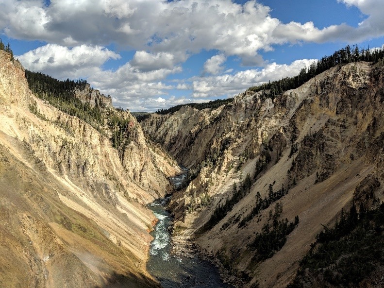 Figure 1: The shuttle will provide service in Yellowstone’s Canyon Village, located near the scenic Grand Canyon of Yellowstone, shown here. Credit: Volpe Center.
The Volpe Center has been providing technical assistance on emerging mobility topics, including considerations around AVs, to NPS since 2018. This support has included the development of a sources-sought request to learn more about automated shuttle technologies and a request for quotes that resulted in the selection of a private vendor to conduct the pilot. Volpe staff have also provided technical expertise on automated shuttle technologies to NPS staff, in part by developing reference materials and making presentations to NPS audiences. These materials and presentations have been used to inform NPS decision-making regarding the automated shuttle pilot at Yellowstone and for possible future pilots at other NPS sites.
Volpe staff will continue to provide technical assistance to NPS as planning for the pilot continues over the next few months. Volpe will also carry out an evaluation of the pilot following its completion in fall 2021. This evaluation will involve assessing the performance of the shuttle and its automated technology based on a range of metrics to be collected during the pilot, including shuttle ridership, route performance, battery performance, and interventions from the shuttle’s safety operator; by assessing the shuttle’s performance in Yellowstone’s remote/recreational setting, the evaluation will inform potential use cases for automated shuttle technologies at other NPS and public land sites.
Project contact: Travis Crayton
When the partnership that runs the parking and shuttle system from the Aspen Highlands parking deck to the Maroon Bells Scenic Area in Colorado’s White River National Forest was faced with the challenge of operating their peak season during a pandemic, the partners immediately began brainstorming how they could safely provide access to the Bells throughout the summer and fall. Fortunately, the public-private group that helps run the nearby Hanging Lake shuttle system offered a possible solution: a reservation system that could be used for the shuttle as well as parking before and after shuttle operation hours.
The Volpe Center worked with the partnership to quickly implement a system that would be ready on opening day. The Forest Service determined they could use the same reservation system used at Hanging Lake, the Roaring Fork Transportation Authority (RFTA) offered to put limited-capacity buses in operation, Aspen Skiing Company opened their parking deck, Pitkin County opened the road up to the Bells, and the Aspen Chamber of Commerce agreed to host the reservation system on their website. In line with a Volpe-developed communications plan, all partners communicated the changes broadly and regularly through social media, press releases, and their websites and email lists.
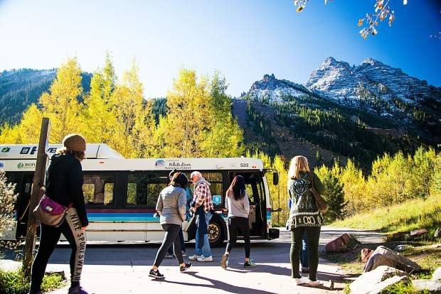 Figure 2: Passengers boarding a RFTA bus (pre-mask wearing mandate). Credit: RFTA.
Though the vehicle and shuttle reservation system often sold out on weekends and busy weekdays, RFTA was able to put additional buses in service on peak fall weekends and the reservation and hotline operator – H2O Ventures – geared up throughout the season to sell no-show tickets to an increasing number of lucky walk-up visitors each day.
In sum, though visitation had to be limited compared to what it was in previous years, the partnership was able to safely accommodate hundreds of visitors every day. Next season, the partners are looking to continue a reservation system, but hopefully at a higher capacity depending on conditions.
Project Contact: Ben Rasmussen
Glacier National Park (GLAC) is home to the National Historic Landmark Going-to-the-Sun Road (GTSR), which has a long record of operational challenges. Growing visitation to the park has resulted in increasing congestion on GTSR. Park administration has considered various management strategies since the 1990s to address the growing volume of traffic entering the park. The National Park Service (NPS) Regional Office serving Interior Regions 6, 7, and 8 asked the Volpe Center to provide a synopsis of past planning studies, analyses, management actions, and pilot service related to the Hiker Shuttle service at the park. The resulting report is intended to serve as a reference document for leadership as they make decisions on the future of operations on GTSR by summarizing and comparing the recommendations, transit systems characteristics, and financial characteristics from these materials and identifying next steps.
Volpe created a vertical timeline to organize the different research, shuttle service, and management actions taken since 1986. The centerline down the middle of the graphic represents GTSR, with the darker gray section identifying when the road was under rehabilitation. The synopsis also highlights various efforts park management has taken to address traffic congestion, mitigate delays from the GTSR rehabilitation project, and communicate to visitors when and where the delays occur. In addition to research and analysis efforts by NPS, the University of Montana, and the Volpe Center, the park deployed technology options, such as using social media to report real-time status information and adding parking lot status updates to the website where campground notifications are posted.
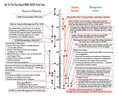 Figure 3: Going-To-The-Sun Road vertical timeline. Credit: Volpe.
Now that the shuttle system has been disrupted by a change in the operational structure of the shuttle and COVID-19, reflecting back on past research, analysis, and pilot services is providing park management with a refreshed lens for looking at managing the corridor into the future. High-level trends from the synopsis include right-sizing the shuttle level of service to match visitation, facilitating car-free access to and in the park, focusing on parking management along with services for hikers, managing the visitor experience, and providing clear and accurate communications with the public.
Project contact: Heather Richardson
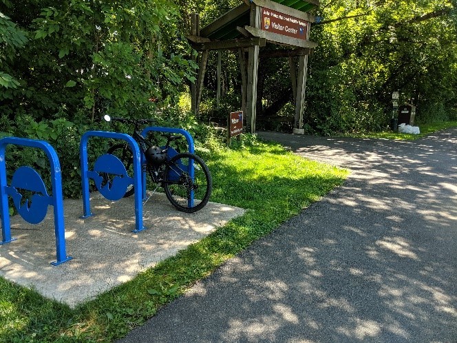 Figure 4: Image of a new bike rack at Heinz NWR. Credit: Volpe.
Philadelphia’s John Heinz National Wildlife Refuge (NWR) is America’s first urban refuge, established to preserve, restore, and develop the natural area known as Tinicum Marsh. The refuge has been working closely with partners in the southwest Philadelphia community to improve transportation connections and access to the refuge and other outdoor opportunities in the community.
As a part of this effort, the Volpe Center has been providing technical assistance to develop and implement strategies to improve transportation access to and within the refuge, with a particular emphasis on connectivity to the southwest Philadelphia community. Volpe support in 2020 built upon prior work, which involved the development of transportation plans focused on improving various elements of access and connectivity.
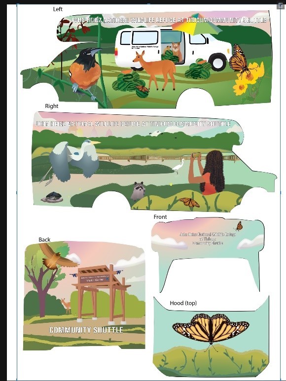 Figure 5: New shuttle wrap for the community shuttle. Credit: Volpe.
Volpe staff worked collaboratively with refuge staff throughout summer 2020 to design a shuttle wrap that will be added to a community shuttle the refuge acquired in 2018. This shuttle has previously been used to provide shuttle service from popular southwest Philadelphia locations to the refuge on busy weekend days. In the future, the shuttle will provide this service, but with a design that reflects both the refuge’s natural characteristics and scenes of the southwest Philadelphia community.
Project Contact: Travis Crayton
 Figure 6: Rachel visiting the Grand Canyon. Credit: Volpe.
What public lands projects are you working on now? What has been your favorite?
I currently manage our portfolio with the National Park Service (NPS) National Capital Area, including trail feasibility studies, asset management, and bicyclist/pedestrian safety and facility design. I also facilitate Volpe's support of the Transportation Safety Program for the NPS Washington Support Office. For the NPS Region 2 South Atlantic Gulf, I perform safety audits, data analysis, stakeholder engagement, transit feasibility studies, and other program support.
It is difficult to pick a favorite when I work on such a diverse range of public lands projects. Working with the Blue Ridge Parkway has been the most rewarding because of the opportunity to work on multiple safety projects. It is satisfying to connect knowledge and recommendations between road safety audits, crash data analyses, and sign inventory evaluations.
What types of projects outside of public lands do you work on?
I also provide support to the Federal Highway Administration (FHWA) and the Federal Emergency Management Agency (FEMA). The FHWA work focuses on virtual public involvement strategies performed by state Departments of Transportation, metropolitan planning organizations, and federal agencies. For this work, I develop written and video case studies, as well as coordinate peer exchanges to share knowledge. I also support disaster recovery work with FEMA, leveraging my background in disaster science and certification as an Associate Emergency Manager. Currently I act as a Liaison for the FEMA Region 1 COVID-19 Long Term Recovery Task Force, coordinating across economic recovery, health and social services, and vaccine distribution planning.
What are your fondest memories of public lands?
The week after I graduated from college, my best friend and I road tripped from Pittsburgh to Denver, and then to the Grand Canyon. We went hiking in Rocky Mountain National Park in May, and there were probably 5 feet of snow on the trails but it was warm enough for just a sweatshirt. As an East Coaster, that was surreal. I immensely enjoyed the juxtaposition between the snowy Rockies and the arid Grand Canyon, watching the landscape change as we drove southwest. It is fun to think back on the pure enthusiasm and awe I felt. I had no inkling that a decade later I would support so many public lands projects!
What new public land have you discovered since working at Volpe?
I had never heard of the Blue Ridge Parkway before Volpe! Now I would like to take a road trip along the entire Parkway, perhaps timing it with the autumn changing of leaves.
What’s the most unique, interesting, or strangest job you had before working at Volpe?
Before working at Volpe, I interned at the Philadelphia Office of Emergency Management. While I was there, the City created the Philadelphia Resilience Project to address the ongoing opioid epidemic through a joint emergency response. There were representatives from every City department and many non-governmental organizations.
If you were to have a job that wasn’t transportation or public lands related, what would it be?
I studied math for undergrad and was interested in mathematical modeling of disease spread. In another life, I could have been a math epidemiologist performing modeling for the CDC or another health organization.
Contact: Rachel Chiquoine
|