|
Located in Philadelphia, the John Heinz National Wildlife Refuge (NWR) became America’s first urban refuge when established in 1972. A green respite within an urban setting, the refuge is home to a thriving sanctuary teeming with a rich diversity of fish, wildlife, and plants native to the Delaware Estuary. Healthy and productive expanses of freshwater tidal marsh, open waters, mudflats, and woodlands support hundreds of species of fish and wildlife that breed, rear their young, rest during migration, or call the refuge home year-round.
As part of an effort to reduce transportation barriers to accessing the refuge, staff asked the Volpe Center to assist in developing strategies to make the refuge more accessible to residents of Philadelphia and the surrounding areas. Volpe Center staff conducted site visits throughout summer 2019 to engage with community stakeholders and refuge staff. Building upon this input, Volpe then developed two plans: a wayfinding/signage plan to improve access within and on approaches to the refuge; and a community shuttle service plan to provide shuttle service to the refuge on select days for southwest Philadelphia residents.
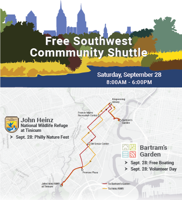 Fig. 1 - Flyer depicting free shuttle program routes, days, and times. Credit: Volpe.
The wayfinding/signage plan outlines detailed recommendations to make navigating to and within the refuge easier and more intuitive for new visitors. The community shuttle service plan builds on two prior pilot efforts undertaken by the refuge to provide shuttle service on select weekend days to southwest Philadelphia residents (Figure 1), with an eventual goal of providing a consistent weekend shuttle service to the refuge.
Project Contact: Travis Crayton
Natural sounds are a vital part of a park visitor’s experience. Whether it is the sound of an owl hooting, a stream running through a historical site, or wind blowing through vegetation, these sounds are a quintessential part of the visitor experience. The Volpe Center supports the Natural Sounds and Night Skies Division (NSNSD) of the National Park Service in its work to protect, maintain, and restore acoustical environments throughout the National Park System.
Fig. 2 - Volpe team collecting roadside pavement noise data. Credit: Volpe.
Tfaffic is one of the most common sources of noise that detracts from the natural soundscape. NPS maintains approximately 5,500 miles of paved roads and 7,000 miles of unpaved roads. Determining the best options to minimize traffic noise is an important component of good stewardship for the parks. To this end, NSNSD has been looking at the benefits of using quieter pavements and common pavement resurfacing treatments in national parks in order to reduce traffic noise. The traditional noise mitigation technique of building noise walls is not practical in the parks due to the long stretches of roadways that must be protected as well as disruption of views and animal traffic patterns. Quieter pavements provide a good alternative to noise barriers since they can reduce noise at the source, which translates to noise reduction at all distances, and they do not disrupt views or animal traffic patterns. The challenges of quieter pavements include performance changes over time coupled with lifespan requirements that can be unique to national parks.
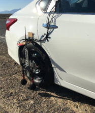 |
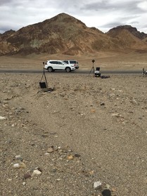
Fig. 3 - Volpe researchers use several methods to study pavement noise at Death Valley. Credit: Volpe.
The Volpe Center is now supporting NSNSD in conducting a pilot study of common pavement resurfacing treatments in Death Valley National Park to determine which may provide the most benefit in terms of noise reduction over time (Figure 2 and 3). The study involves measuring the noise levels before and after four different surface treatments have been applied. The surface treatments include two chip seals and two micro-surfaces. Measurements one year after the treatments have been applied show a difference in noise levels of almost 3 dB between the treatments. A decrease of 3 dB is equivalent to a 50 percent reduction in traffic volume. The study is planned to span five years and is currently preparing to measure the performance of the pavements after the third year.
Contact: Aaron Hastings
The beautiful Eagles Nest Wilderness sits adjacent to the Town of Vail and just north of Interstate 70 in Colorado’s White River National Forest. Over the past several years, an increasing number of people hike into Eagles Nest via four trails in East Vail. These trailheads have become very crowded on busy days, and safe and legally designated parking has become nearly impossible to find on those days.
This past summer, the White River National Forest and the Town of Vail asked the Volpe Center to help identify ways to spread out and reduce the number of hikers on these trails during busy times so that people can safely access the trails and have more of a wilderness experience in the Eagles Nest.
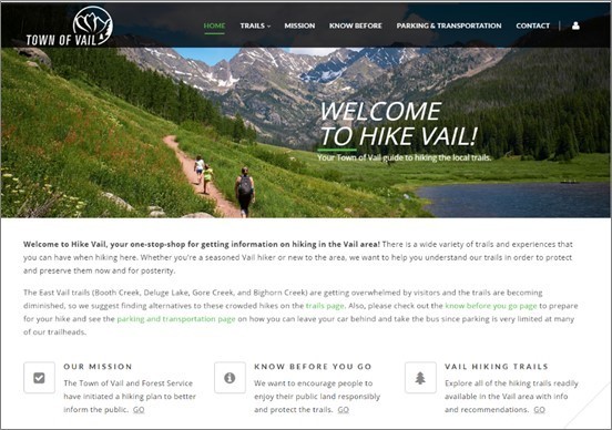
Fig. 4 - A snapshot of the new HikeVail.net website. Credit: Town of Vail.
As a first step, the Volpe Center worked with the Forest Service and the town to develop a new website, www.hikevail.net (Figure 4), that uses trail counter data to inform people’s decisions on when the least crowded times are to access the East Vail trails or to look for good alternative hikes in the area. Specifically, Volpe used the counter data to show how busy different days of the week are in each month of the summer (Figure 5) based on how many hikers there were during that month last year. Provided with this information, visitors could then change their plans to another day, time, or location to hike. This information was also distributed to concierge and front desk staff at local hotels to inform the advice that hotel staff give to their visitors.
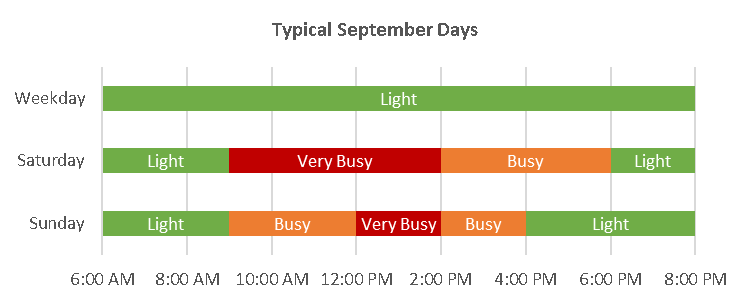 Fig. 5 - Typical hiker traffic on Booth Creek Trail in September. Credit: Volpe.
Over the next several months, the Volpe Center is going to work with the town and the Forest Service to implement visitor management strategies at each of the trailheads.
Contact: Ben Rasmussen
The Volpe Center is currently conducting an Alternative Transportation Study for the National Park Service (NPS) Morristown National Historical Park (MORR) in Morristown, NJ. This NPS unit is composed of multiple separate areas including a museum and historic residence where General Washington resided through a historically cold winter during the Revolutionary War and the site of a historic fort. Both lie in close proximity to downtown Morristown and alternative transportation networks, including commuter rail, multi-use paths and trails, and walkable/bikeable neighborhoods. Other nearby non-NPS destinations include a county historical society, historic residences, museums, and an arboretum. Two other neighboring park areas are forested lands where Revolutionary War soldiers encamped, featuring an extensive network of trails and a loop road that is well used by locals and visitors alike. Additional non-NPS land adjacent to these sites features recreational fields and a wildlife sanctuary.
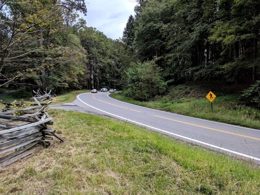 |
Fig. 6 - Roadway with pedestrian crossing at MORR. Credit: Volpe.
Volpe is exploring ways to better connect these four Park Service areas with each other and with the surrounding community via alternative transportation. The project team held multiple in-person and remote stakeholder meetings with over 20 representatives of local municipalities, agencies, cultural and historical groups, elected bodies, and non-governmental organizations. These meetings helped establish partnerships to coordinate local and regional projects, address multimodal access and circulation, improve bicycle and pedestrian safety, and align tourist/visitor wayfinding. Park staff and these local stakeholders now have a better understanding of their shared travel needs and the benefit of coordinating planning and pursuing alternative transportation improvement projects together.
 Fig. 7 - Footpath at MORR. Credit: Volpe.
The park’s future efforts include encouraging improved off-street pedestrian/bicycle connections and improved on-roadway pedestrian and bicycle facilities; piloting bike share; and communicating to visitors more clearly and effectively about how to travel via motorized and non-motorized means between Park Service and other local cultural and tourist destinations. The park will also be working collaboratively to anticipate and accommodate forecasted increases in visitation associated with “USA250” leading up to and including the Semiquincentennial in 2026.
Contact: Jonah Chiarenza
What public lands projects are you working on?
I manage Volpe’s portfolio of work with the National Park Service (NPS) Interior Region 2 Atlantic Gulf (previously called the Southeast Region) and serve as deputy portfolio manager for our NPS Washington Support Office (WASO) Transportation Branch portfolio. The regional work includes safety studies such as road safety audits at priority locations, crash data analysis, and site-specific safety countermeasure recommendations. We also support the region with multimodal and transit planning, ferry rehabilitation, and project selection. For WASO, we’re currently helping NPS consider emerging trends in transportation technology and the implications for national parks and visitors. These trends include shared mobility services like electric scooters and ride hailing, traveler information technologies, and vehicle automation.
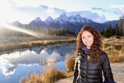 Fig. 8 - Amalia Holub at Grand Teton National Park in Wyoming. Credit: Volpe.
What types of projects outside of public lands do you work on?
lead our portfolio for the Federal Highway Administration Office of Human Environment. This work covers topics such as quality of life, bicycle and pedestrian access and safety, environmental justice, and multimodal connectivity. Currently, we’re helping this office examine the federal versus state and local roles in micromobility (such as electric scooters and bike share) and we’re developing case studies to highlight best practices on this rapidly evolving topic.
What are your fondest memories of public lands?
Growing up in rural northern California at the base of Mount Shasta, I spent much of my childhood on public lands, including the Shasta-Trinity National Forest. I have very fond memories of hiking, skiing, and swimming at natural sites in the area (Figure 8), and river rafting on the Klamath River, part of the nearby Klamath National Forest.
What new public land have you discovered since working at Volpe?
Last year, I had the opportunity to visit Yellowstone and Grand Teton national parks as part of a project to support the NPS with its transportation funding strategy (Figure 9). I was amazed at the beauty of the landscapes and the abundant wildlife—waiting for a herd of bison to cross the road and seeing them up close was a memorable highlight at Yellowstone.
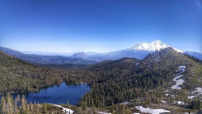 Fig. 9 - Castle Lake, part of the Shasta-Trinity National Forest, is Amalia's favorite place to swim in her hometown of Mount Shasta, CA. Source: U.S. Forest Service, Shasta-Trinity National Forest.
What’s a unique, interesting, or strange job you had before working at Volpe?
For my first transportation-related job a decade ago, I worked in Buenos Aires, Argentina, for a year and a half with an international non-profit called the Institute for Transportation and Development Policy. We helped the city government with projects including bicycle infrastructure planning, bike share, and bus rapid transit. It was a great opportunity to gain an international perspective on transportation planning at a time when Buenos Aires was just starting work on these projects and then to be able to see how the city changed dramatically in just the short time I was there.
If you were to have a job that wasn’t transportation or public lands related, what would it be?
Since I love to cook and I’m very interested in health and food systems, I’d most likely find a career path related to nutrition.
Contact: Amalia Holub
|