|
After almost seven years of planning, the Hanging Lake Shuttle officially opened on May 1, 2019 in Glenwood Springs, Colorado. Since 2012, visitation to Hanging Lake has more than doubled to nearly 200,000 visitors annually and over 1,200 on peak days as the site has been listed in several magazines and websites as one of the must-see places in Colorado and one of the best waterfalls in the United States. The increased visitation has led to damage to trails and vegetation, unsafe conditions as cars back-up onto the interstate as they wait for limited parking, and overcrowded trail conditions.
Hanging Lake, located in Glenwood Canyon in the White River National Forest, is a rare example of a travertine geological formation. Over the years, water flowing over Bridal Veil Falls has deposited dissolved carbonates to build up a fragile lake edge. Because of its uniqueness, the area was designated a National Natural Landmark in 2011.
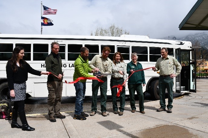 Attendees cut the ribbon for the Hanging Lake Shuttle Grand Opening. Credit: USFS.
Informed by Volpe reports on visitor survey results and the site’s carrying capacity as well as a transportation operations plan, the U.S. Forest Service put a management plan in place in 2018 to protect Hanging Lake for future generations. Stakeholders for the project included the Forest Service, the Colorado Department of Transportation, the City of Glenwood Springs, Garfield County, and other members of the public. Visitors now reserve a seat on a shuttle that runs every 45 minutes from Glenwood Springs to the parking lot, with capacity for over 600 visitors a day. The parking lot is now closed to private vehicles from May 1 to October 31, limiting crowding and enhancing the visitor experience in the forest.
In addition to the reports mentioned above, the Volpe Center has facilitated a stakeholder group that has been working on management issues at Hanging Lake for the last six years, participated in public meetings, developed video simulations, and has advised on implementation of the shuttle service. Initial reception of the shuttle service has been very positive, and Volpe will continue to assist in developing the program.
Hanging Lake Alternative Transportation Study
Project Contact: Ben Rasmussen
In May 2019, Volpe and the National Park Service (NPS) completed work on two related projects at Klondike Gold Rush National Historical Park (KLGO): a transit feasibility study for the Dyea unit and a congestion assessment for the Skagway unit in collaboration with the Municipality and Borough of Skagway (MBS). These two projects addressed two of KLGO’s primary transportation challenges: pedestrian congestion and safety in downtown Skagway, and providing access to more remote recreation sites at Dyea.
KLGO is the most-visited NPS unit in Alaska with over 1 million visitors in 2018. The vast majority of these visitors arrive by cruise ship in Skagway and travel to the unit by foot. As a result, downtown Skagway experiences heavy pedestrian traffic and related safety and congestion issues. For example, large numbers of pedestrians lead to overflowing sidewalks, and pedestrians then walk in the street, where they mix with tour bus traffic. KLGO also manages the Dyea unit, located approximately 10 miles from Skagway along a narrow gravel road. This area includes the ghost town of Dyea and the trailhead for the historic Chilkoot Trail that miners hiked on their journey to the Klondike gold fields. KLGO has recently developed new, wheelchair-accessible interpretive trails at Dyea, but the area is difficult to access for cruise ship passengers due to limited transit options.
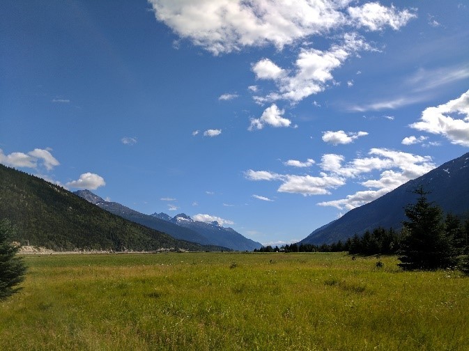 Views of the Dyea unit at Klondike Gold Rush National Historical Park. Credit: Volpe.
NPS asked the Volpe Center to conduct a transit feasibility study to assess opportunities to enhance transit access from Skagway to Dyea through partnerships with local public or private transit providers. The final report documents the project team’s findings, including a summary of existing conditions and stakeholder input, characteristics of a potential transit shuttle between Skagway and Dyea, business model considerations, and an assessment of potential transit vehicle types.
While Volpe conducted the Dyea transit feasibility assessment, KLGO recognized the additional need to study pedestrian congestion issues in Skagway. The NPS Alaska Region (AKR) invited staff from the NPS Washington Support Office (WASO) to conduct a congestion assessment in Skagway with support from the Volpe Center. Because the transportation infrastructure in Skagway is owned and managed by MBS, this project was a collaboration with MBS and provides a potential model for future NPS congestion assessments in more urban park unit settings. The project team worked with MBS staff and stakeholders to identify opportunities to manage congestion in Skagway, which were categorized under wayfinding and signage, safety, and vehicle circulation.
Together, the KLGO transit feasibility study and congestion assessment provide a coordinated assessment of opportunities to improve transportation access to KLGO. They also may provide valuable resources for other parks with a substantial number of cruise ship visitors.
Project Contact: Erica Simmons
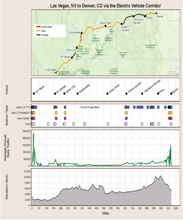
Electric vehicles (EVs) are a growing part of transportation and mobility in the United States. Several donors recently provided funds for the National Park Service (NPS) to install new EV charging stations, promoting EV mobility to and from parks by enabling visitors to charge their EVs during visits. In light of these donations, NPS needed to prioritize investments. As part of this, NPS sought to determine where enroute charging was lacking between parks and key population centers. This study served a secondary purpose of guiding future discussions with partners that may be able to facilitate the installation of enroute charging, such as other Federal agencies, state and local governments, and regional coalitions.
NPS asked the Volpe Center to analyze gaps in the EV charging station network that impede EV access to park units. Volpe partnered with NPS to develop a geospatial framework for identifying and prioritizing gaps in EV charging infrastructure along routes connecting park units to key population centers and transportation hubs.
 Example of a linear diagram showing factors for consideration in identifying and prioritizing infrastructure gaps. Credit: Volpe.
Determining the best locations for EV charging stations is challenging because: (1) any prioritization framework would depend on factors that are likely to change substantially in the near future, such as the distance EVs are able to travel between charging and the locations of existing charging stations; and (2) the magnitude and timing of changes are uncertain because they, in turn, depend on many factors, including but not limited to new innovation and market adoption. For these reasons, the Volpe team automated the geospatial analysis to allow for easy replication and future updates. The resulting analytical framework helps NPS to visualize and understand key gaps in EV access on a park-by-park basis or for clusters of co-located park units. As a semi-automated tool, it enables NPS to perform future analyses efficiently and adaptively on an ongoing basis.
In addition to this park-level tool, Volpe and NPS also developed a nationwide screening method to infer which park units are already relatively accessible via EV or are likely to be in the near future. This method helped identify the largest remaining gap for EV access, as measured by visitation, which is in the four corners area of the Intermountain Region. This area has a cluster of high-visitation parks with limited accessibility for EVs.
Project Contacts: David Daddio, Andrew Breck
As electric vehicle technology advances, it is becoming increasingly available for transit bus platforms. Battery-electric buses (BEB) have the potential to help transit agencies meet sustainability goals and reduce fuel and maintenance costs, but they also have higher capital investment costs and require different infrastructure, operations, and maintenance considerations than conventionally fueled vehicles. As a result, BEBs require careful consideration (e.g., comparison of full life-cycle costs) prior to purchase and adoption.
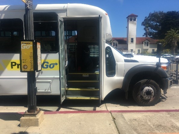 The PresidiGo Capital Plan evaluated the potential of transitioning buses to battery-electric power. Credit: Volpe.
February 2019, the Volpe Center completed the PresidiGo Capital Plan for the Presidio Trust. This report evaluates the benefits and challenges associated with transitioning the Presidio Trust’s transit fleet from Compressed Natural Gas (CNG) buses to BEBs.
The Presidio Trust is a federal agency that manages the Presidio of San Francisco, a 1,500-acre former military post at the northern tip of San Francisco, in partnership with the National Park Service and the Golden Gate National Parks Conservancy. The Presidio Trust preserves the park’s unique historical and natural resources and provides recreational access at no cost to taxpayers by raising revenue from leasing homes and commercial space throughout the Presidio. The PresidiGo transit system consists of three transit routes that serve the transportation needs of the residents, employees, and visitors in the Presidio. The PresidiGo transit fleet consists of a mix of medium-duty and heavy-duty transit buses, all of which currently run on CNG.
Last year, the Presidio Trust asked the Volpe Center to assess the benefits and challenges of transitioning its fleet from CNG to BEB and to develop a potential transition plan given the fleet’s capitalization, operations and maintenance needs, charging infrastructure requirements, and concurrent development plans in the Presidio that will impact transportation operations. The PresidiGo Capital Plan presents a technical analysis, recommendations, and conclusions regarding the management of the future transit fleet. The plan recommends a BEB pilot to evaluate and gain familiarity with BEBs prior to a full fleet transition and discusses potential funding sources and incentives to fund the purchase of BEBs and the installation of electric charging infrastructure.
PresidiGo Capital Plan: A Technical Analysis of Alternative Transit Fleet Fuels and Transition Strategy
Contact: Erica Simmons
What public lands projects are you working on now?
I am supporting the Bureau of Land Management (BLM) on their first National Long-Range Transportation Plan (NLRTP). As the largest land owner in the United States with a multi-use mission unlike any other federal lands management agency, the BLM is faced with considerable challenges when it comes to planning its transportation system. I have enjoyed working on this challenging initiative, which has brought together staff from all levels and a number of disciplines within the BLM.
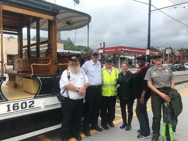 Katie (third from the right) with staff from Lowell National Historical Park (NHP) and the Federal Transit Administration on a site visit to Lowell NHP to discuss next steps for improving multimodal connections to the urban park. Credit: Christine Bruins, NPS.
I am also working with the Northeast Region (NER) of the National Park Service (NPS) to support its alternative transportation program and to improve multimodal connections to and through parks across the northeast. We just kicked off two multimodal access studies for park units in the northeast. Both of these studies are looking at how they can improve bicycle, pedestrian, and transit connections as well as leverage local partnerships for bike-share.
I have also recently started working with our partners at the Department of Defense (DOD) Surface Deployment and Distribution Command (SDDC) to help better understand and address the unique transportation planning challenges that they face on- and off-base.
What types of projects outside of public lands do you work on?
Most of the projects that I work on outside of public lands are with the Federal Highway Administration and Federal Transit Administration. This work focuses on helping state Departments of Transportation (DOTs), Metropolitan Planning Organizations (MPOs) and transit agencies meet transportation planning and programming requirements. This work has informed the work that I do with public lands since it gives me a real sense of state DOT and MPO transportation planning best practices and lessons learned from across the country, which can be adapted and applied to public lands.
I also support our disaster recovery work with the Federal Emergency Management Agency (FEMA) and recently provided support for transportation response and recovery efforts from Hurricane Michael in Florida and the 2018 wildfires in California.
What are your fondest memories of public lands?
When I was in college a group of us took a hiking trip into the Grand Canyon and camped under the stars at Havasu Falls. I remember being completely awestruck seeing those majestic falls after our 10-mile hike into the canyon and being so excited to get into the blue-green sparkling water. That night, since we were mostly first-time backpackers and had not packed sufficiently, we had a feast of partly cooked pasta and rotten apples – an unforgettable meal that we still like to talk about.
What new public land have you discovered since working at Volpe?
The most recent public land I have discovered since working at Volpe is actually an urban park less than an hour from our office in Cambridge. I had the pleasure of visiting Lowell National Historical Park last fall. As a transportation planner, I was excited by our multimodal tour of the park, which included a walking tour, trolley tour, and boat tour.
What’s the most unique, interesting, or strangest job you had before working at Volpe?
I had a summer job counting jelly fish bellies (I was a marine biology student interning at Woods Hole Oceanographic Institute).
If you were to have a job that wasn’t transportation or public lands related, what would it be?
High School Biology Teacher
Contact: Katie Lamoureux
|