|
The National Park Service (NPS) is required by law (23 U.S.C. 201) to implement a congestion management system, along with bridge, pavement and safety management systems, to aid in data-driven decision making and sound asset management. As part of its Congestion Management Program, the NPS has a Congestion Management Toolkit, which outlines more than 50 congestion mitigation tools specifically selected for NPS congestion conditions and concerns.
NPS has established Congestion Assessments as a way to provide short-term technical transportation support to parks regarding congestion. Parks with vehicular congestion have difficulty managing excessive traffic, which impacts visitor experience, resources, safety, asset management, and park operations. Every park is unique, as are each park’s congestion issues. Congestion Assessments use a structured approach to explore high-level park congestion issues and information then match those issues with the wide range of potential tools in the Toolkit. Volpe Center staff work with staff from NPS, Federal Highway Administration (FHWA), Federal Lands Highway (FLH), and individual park units to understand each park’s congestion issues and to help identify the tools that can be used to address their individual congestion challenges. In the past two years, Volpe has collaborated with the NPS and FLH to assist several parks with completing Congestion Assessments:
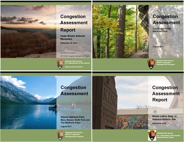 The covers of several Congestion Assessment reports that the Volpe Center has supported.
Assessments completed in 2016:
-
Cedar Breaks National Monument (Utah)
- Martin Luther King, Jr. National Historic Site
(Georgia)
- Virgin Islands National Park (St. John, U.S.
Virgin Islands)
Assessments completed in 2017:
- Cuyahoga Valley National Park (Ohio)
- Fort McHenry National Monument and Historic
Shrine (Maryland)
- Glacier National Park, Many Glacier, North Fork,
and Two Medicine Areas (Montana)
- Great Falls Park, George Washington Memorial
Parkway (Virginia)
Volpe’s transportation expertise and experience working on a
wide variety of transportation related challenges on Federal public lands has
contributed to Volpe’s ability to help parks take the congestion issues they
are experiencing and match them with potential solutions. Collaboration with
Federal partners at NPS and FLH furthers the depth of knowledge within an
assessment team. The Congestion Management Program team follows up with each
park approximately six months after the assessment concludes to determine
whether any additional assistance is needed as they move toward implementation.
While the Congestion Assessments are not final
decision-making documents or transportation plans, they complete the first
three steps of the seven-step NPS Congestion Management process needed to move
potential solutions into implementation. The remaining steps include (4)
analyzing and selecting solutions, (5) implementing solutions, (6) monitoring
the effectiveness of the solutions, and (7) revisiting the toolkit if
congestion is not adequately resolved. Post-assessment technical support
following these steps is available from regional transportation coordinators,
the NPS’ Denver Service Center, FLH, and the Volpe Center.
Project Contact: Heather
Richardson
The U.S. Army Corps of Engineers continues to rely on a
variety of vehicle counter (“meter”) technologies – magnetic loops, pneumatic
tubes, and infrared meters – in order to obtain accurate visitation data for
visitors arriving to its recreational lakes and sites around the country. Having
an accurate representation of visitation patterns enables the Corps to better
allocate its limited transportation funds. This enhances the transportation
planning process by ensuring that these limited resources are assigned to areas
of greatest need and highest visitation.
The Volpe Center has performed site visits and in-person trainings for Army
Corps field staff on vehicle meter best practices. In an effort to bolster its
vehicle counter program, Volpe is developing a series of videos for the Corps
aimed at educating field staff on best practices for counter selection,
installation, configuration, testing, and maintenance.
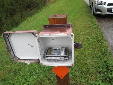 To ensure accuracy, magnetometers should be enclosed in a lockable fiberglass box buried underground or mounted to a post, as shown in the photo above.
The first video describes the basic characteristics of
TRAFx magnetometers, by far the most common meter type utilized by the Army
Corps. The video provides instructions for meter installation, how to adjust
delay and threshold settings depending on roadway configurations, and tradeoffs
among different model types. In order to count vehicles accurately, TRAFx
magnetometers require careful attention to settings. The default settings are
typically not appropriate for Army Corps sites, where vehicles tend to drive more
slowly than on other public roadways. Incorrect settings can cause vehicle
counts to be off by a factor of two or more.
The TRAFx meter video is available for viewing at: https://www.youtube.com/watch?v=yjafFy0jPQ4.
Additional videos, expected to be developed in summer 2018, will address best
practices for recording monthly meter readings, avoiding meter resets when
changing batteries, and proper maintenance techniques.
Project Contact: Michael
Kay
Now in its sixth year, the
National Park Service (NPS) Transit Inventory collects data on transit systems
operating in parks across the country, helping the NPS build a
performance-based framework and communicate key system characteristics.
Transit in national parks takes the form of land, water, and
air based systems and ranges from larger systems, like the 90+ bus system in
Denali National Park and Preserve in Alaska, to the single shuttle bus at
Kennesaw Mountain National Battlefield in Georgia. The NPS operates a small
number of these systems, but largely partners with the private sector and a
number of local transit agencies to provide these services to enhance the
visitor experience. These services help reduce the impact of private vehicles
on park roads and resources and also help address overcrowding as visitation
continues to increase at many national parks.
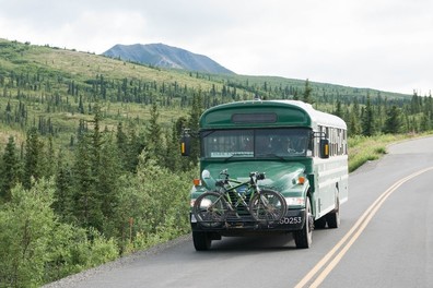 Since 1972, Denali National Park and Preserve has limited access for private vehicles on its 92-mile Denali Park Road to reduce the environmental impact of vehicles. Visitors can access the Park Road through a number of transit services offered by the park concessionaire.
When the inventory began in
2012, it was the first comprehensive listing of transit in national parks since
1998. The Volpe Center worked with NPS staff to develop a working definition of
what constitutes a transit system in a national park, thereby helping fulfill
legal requirements and internal NPS needs. The Volpe Center Public Lands Team
provides support for the inventory through coordinating the data collection
with park units and working with the Washington D.C. Support Office to refine
the data analyses and performance measures included in the yearly reports. The
performance measures help the NPS track the environmental and operational
impacts of the transit systems as well as recapitalization needs for transit
vehicles on a service-wide level. Key statistics from the latest Transit Inventory and
Performance Report (2016) include:
- In calendar year 2016, 100 transit systems
operated in 64 of the 417 NPS units. The majority of the transit systems are
shuttle bus, van, or tram-based systems and private contractors in cooperation
with public sector partners operated 81 of the 100 identified systems. These 81
systems, which are supported by user fees and fares as well as capital funding
from the Federal Lands Transportation Program, account for approximately 99
percent of the 43.6 million transit passenger boardings. The remaining 19
systems are relatively small and are owned and operated by the NPS.
- 29 of the 100 transit systems provide visitor
access to parks and park sites that are not otherwise accessible by private
automobile because of natural/cultural resource constraints, congestion, and
geographic constraints (i.e., water bodies).
- Of the 843 vehicles utilized in the 100 transit
systems, the private sector provides over 67 percent or 565 vehicles. The
remaining 278 vehicles are provided by the NPS to reduce contracting costs and
make particular services affordable to visitors. These NPS-owned vehicles,
which are typically operated and maintained by contractors and partners, will
experience an estimated $40 million in recapitalization needs between 2017 and
2027. This includes $5 million to replace vehicles that have already exceeded
their expected life.
The
yearly data collected for the transit inventory provides a useful snapshot of
transit operations in parks, allowing for longitudinal analyses and building
towards a performance-based framework for NPS transit systems.
Project Contacts: Jessica
Baas and David Daddio
 The Volpe
Center Public Lands Team congratulates the National Park Service on winning a
Gold National Planning Achievement Award in Transportation Planning from the
American Planning Association for its National Long Range Transportation Plan.
Volpe is pleased to have supported the Washington D.C. Support Office’s
Facilities Planning Branch in developing this plan and managing the project in
collaboration with a team from the Park Service’s Denver Service Center. Volpe
continues to support NPS in tracking its national performance measures and
goals, and the overall implementation of the plan.
Project Contact: Kevin
McCoy
|
What public lands projects are you
working on now?
I am assisting the U.S. Army Corps of
Engineers (USACE) in meeting the planning requirements of the Federal Lands
Transportation Program. This includes supporting the development of
investment strategies, accomplishments reports, policy white papers, and
eventually their first National Long Range Transportation Plan. I also support
the National Park Service with implementation of its Capital Investment
Strategy. Lastly, I am working with various agencies to complete the Pacific
Northwest Collaborative Long Range Transportation Plan.
What types of projects outside of
public lands do you work on?
I work with the Federal Highway
Administration Office of Transportation Performance Management to implement
rulemakings related to performance management, ensuring that requirements are
met and performing outreach to key stakeholders such as State DOTs and metropolitan
planning organizations. Performance management is a fairly new, yet critical,
element of transportation planning, and it is our expectation that these
entities will be better positioned to improve decision making through active
quantification of certain key performance metrics. Additionally, I support the
Federal Railroad Administration in the development of regional planning
guidance.
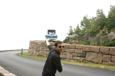 Michael used the Island Explorer shuttle bus on a trip to Acadia National Park.
What are your fondest memories of
public lands?
Growing up, I almost never visited
public lands aside from a rare visit to a local or state park. My family tended
to prefer being by a pool or a beach rather than being in the forest or
mountains. But I am making up for lost time! In the dozen or so
years since I’ve been at Volpe I have visited most of the major national parks,
as well as various national wildlife refuges, national forests, and Army Corps
recreation sites. My favorite trip was to Arches National Park, where I got up
at 3:00 in the morning to arrive in time to secure a same-day reservation at
the lone campsite within the park itself. Another memory, though an
embarrassing one, was while at Yellowstone. Feeling out of touch due to
minimal cell phone service, I came upon an outpost that had a sign that looked
like the standard semi-circular Wi-Fi icon. When I went inside to inquire, they
laughed at me and said the symbol I saw was actually indicating the presence of
an amphitheater, not Wi-Fi! I suppose the lesson there is that there’s
more to life than Wi-Fi, especially while at a place like Yellowstone.
What new public land have you
discovered since working at Volpe?
I have become quite fond of the USACE
recreation sites. In many parts of the country, there is little to no access to
water-based recreation, but the Corps helps to fill that void by creating
man-made lakes that exist as a result of locks and dams built nearby.
What’s the most unique, interesting, or
strangest job you had before working at Volpe?
Back during the 2000 Presidential
election, I worked for a company in charge of aggregating official election
results and entering them into a database that fed into all major news
outlets. Having direct access to the returns, I can honestly say I was
among the first to know how close that election was going to be!
If you were to have a job that wasn’t
transportation or public lands related, what would it be?
Since my dream of being a major league
baseball player died fairly soon after joining Little League, I would say I’d
most likely still be an urban planner but in a different related field, such as
housing or urban design.
Contact: Michael Kay
|