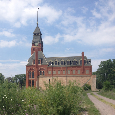
 A view of the Administration Building at the Pullman National Monument, which will be renovated into the new visitor center.

The National Park Service (NPS) preserves and protects
diverse special places throughout the United States, including monuments and
historic sites, along with the big, iconic natural areas in the West. In 2015,
the Pullman train-car factory and surrounding neighborhoods on the far South
Side of Chicago were designated as an NPS National Monument. Pullman was the site
of the first planned industrial community in the United States and is the first
NPS unit in Chicago. After the designation, the Chicago Metropolitan Agency for
Planning (CMAP) initiated a transportation plan for Pullman and engaged the
Volpe Center Public Lands Team to help develop this plan.
CMAP and its partner the National Parks Conservation
Association (NPCA) wanted to ensure that the unique transportation needs of the
National Monument and the NPS were addressed in the plan while also supporting
neighborhood residents and businesses. To meet this need, the Volpe Center
Public Lands Team drew upon our extensive experience working with urban NPS
units, developing five case studies of similar units to inform the plan. Volpe
also worked to help the project team identify potential funding opportunities
for projects in the plan, leading to a Federal Lands Access Program grant
application for a “complete streets” redesign of 111th St., which
cuts across the center of the National Monument.
Partnerships are essential to the success of urban NPS units
like Pullman. So it is only fitting that the Pullman Transportation and Access
Plan was developed by a team of dedicated partners, including CMAP, NPCA, the
NPS, Sam Schwartz Consulting, Teska Associates, and the Volpe Center, with
regular input from numerous transportation agencies in the Chicago metropolitan
area and surrounding community members and businesses. The plan also builds upon
a vision for Pullman developed by NPCA and the American Institute of Architects
Chicago: Positioning Pullman.
The Pullman Transportation and Access Plan provides
recommendations for how these partners can work together to leverage Pullman’s
urban context as a transit and non-motorized transportation-oriented NPS unit
with a campus-like feel. The plan seeks to provide visitors with an opportunity
to experience the historic model town layout on foot, as workers and residents
did during its heyday. It also minimizes negative impacts on current Pullman
residents while supporting continued commercial and industrial growth in this unique
Chicago neighborhood. The Pullman
Transportation and Access Plan is near completion, and will be available this
summer.
Project Contact: Kevin
McCoy and Jessica Baas
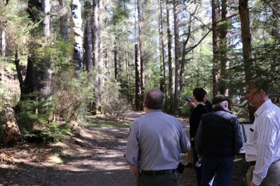 FLMA, FHWA, and Alaska DOT staff tour transportation projects as part of a recent Alaska Collaborative LRTP workshop.
Over the past several years, federal lands
management agencies (FLMAs) have developed long-range transportation
plans (LRTPs) at the unit, regional, and national levels. These LRTPs are
policy-level plans that help agencies navigate transportation funding and
management decisions over the next 20 years, similar to the LRTPs developed by
State Departments of Transportation (DOTs) and Metropolitan Planning
Organizations (MPOs). Now that FLMAs have successfully completed many LRTPs
across the country, the next challenge is to periodically update them so that
they are evolving plans that reflect current conditions. Currently, work is
underway to develop the first LRTP update for federal lands in Alaska.
The update to the Alaska
Federal Lands Collaborative LRTP will be the first LRTP update for FLMAs.
The original Alaska Federal Lands LRTP, completed in 2012, was a pioneering
effort to develop the first multi-agency LRTP for federal lands. The 2012 Alaska
Federal Lands LRTP was a collaborative effort between the following FLMAs and
their partners:
- Bureau of Land Management (BLM)
- National Park Service (NPS)
- U.S. Fish and Wildlife Service (FWS)
- U.S. Forest Service (FS)
- Federal Highway Administration, Western Federal
Lands Division Office (WFL)
- Alaska Department of Transportation and Public
Facilities (ADOT & PF)
Volpe is supporting this update by researching existing
conditions, advancing performance management, and conducting financial analyses
of available funds, needs, and gaps based on available data from each agency.
Volpe will also develop the updated plan content for publication. The update
process also includes several workshops to bring together the multi-agency team
to work together in-person.
For the Alaska LRTP, the multi-agency team will not rewrite
the plan, but will build off of the work accomplished in 2012. The update will
accomplish the following:
- Reflect new requirements and funding
opportunities in the Fixing America’s Surface Transportation (FAST) Act of
2015;
- Use updated transportation and visitation data
to provide up-to-date information on the condition and needs of federal lands transportation networks in
Alaska;
- Align the updated collaborative LRTP with NPS
and FWS National LRTPs and other FLMA national guidance;
- Report on FLMA and partner accomplishments since
the 2012 plan; and
- Build upon the interagency team’s progress to
develop performance measures and monitoring systems.
As part of this update, the multi-agency team will also
document their process to provide a template for other FLMA regions as they
update their LRTPs. The multi-agency team aims to demonstrate how to update an
LRTP efficiently. The Alaska Federal Lands LRTP update is expected to be complete
by October 2018.
Project Contact: Erica
Simmons
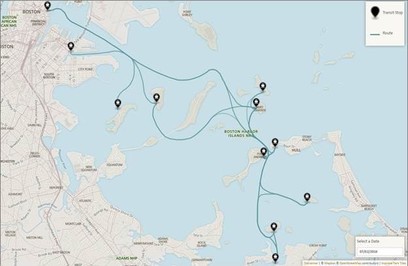 Prototype map automatically generated from digital transit schedule data at Boston Harbor Islands National Recreation Area.
Transit commuters across the country are increasingly accustomed to
using apps (smartphone applications) to check the schedules and status for
their train, bus, or other transit service. These apps are built on transit
agencies sharing their schedules in an open digital format, bringing attention
to existing transit service and increasing predictability for riders. Beginning
in 2015, the National Park Service (NPS) Transportation Branch, with support
from Volpe, conducted a pilot to determine whether sharing NPS transit
schedules in this app-friendly format could offer similar benefits for visitors
using transit in national parks.
The project team worked with three pilot parks—Boston Harbor
Islands, Cuyahoga Valley, and Rocky Mountain—to release their seasonal transit
schedules as open data using the industry-standard General Transit Feed
Specification (GTFS) format. Mobile app developers like Google Maps, Apple
Maps, Chimani, and National Geographic can read data in this format and use it
to share upcoming arrival and departure information with their users. NPS
publicized the release of the open-source transit data, and a number of app
developers are now sharing this schedule data with visitors.
As part of the pilot, the project team discussed the
effectiveness of third-party data sharing with park staff, strategies for other
parks interested in sharing this data, and recommendations for long-term
maintenance of the feeds. The pilot suggests that while releasing digital
schedule data and promoting to third-party app developers is low cost and can
be useful for some visitors, parks should release digital schedule data as part
of broader visitor outreach plans that include official NPS digital tools like
nps.gov and NPS mobile apps. Volpe and NPS may follow up on this project with a
focus on integrating this type of data into official NPS tools.
The pilot
report is available on the National Transportation Library and the GTFS
data is available through NPS’s GitHub.
Project Contact: Logan
Nash
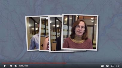 A screenshot of the new Public Lands Team video.
To highlight its capabilities and impact over the last
decade, the Public Lands Team recently produced a short video. The video
features members of the Public Lands Team, as well as footage from projects
across the country. You can view the video at: https://youtu.be/ZdIbSQU76KE.
This video is one of many that the Public Lands Team has
produced for a variety of purposes, including a training video for Bureau of Land
Management (BLM) staff and an informational
video for the Northwest Collaborative Long Range Transportation Plan.
Project Contact: Benjamin
Rasmussen
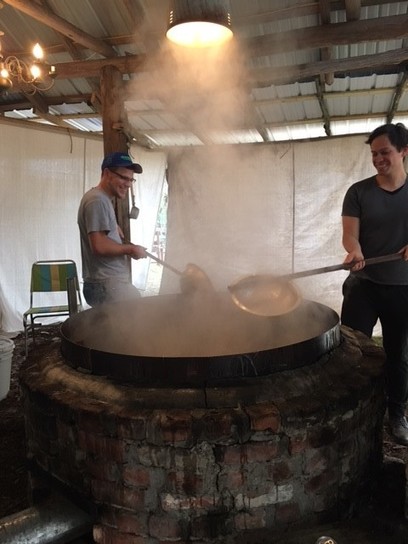 Pete Tomczik (left) and Anders Kosnett boiling sugarcane syrup. Hortense, GA.
Anders Kosnett and Pete Tomczik joined the Volpe Center in
the fall of 2016 to provide targeted technical assistance to the U.S. Fish and
Wildlife Service (FWS). Read on to find out more about the Public Lands Team’s
two newest members.
What public lands
projects are you working on now?
Anders:
Currently, we’re working with FWS to review and improve the recordkeeping and
maintenance procedures that ensure tens of millions of visitors can safely and
reliably experience American wilderness, per the FWS mission to provide the
public opportunities to understand, appreciate, and wisely use fish and
wildlife resources. Updated every 5 years, the Road Inventory Program (RIP) is
intended to deliver consistent, detailed reports on the conditions of all of
the transportation infrastructure at National Wildlife Refuges and National
Fish Hatcheries and other public spaces maintained by the FWS: roads (for
automobiles and cycling), parking lots, trails, bridges, etc. I’m partnering
with the FWS transportation coordinator for the Midwest as they collect,
update, and align data between Refuge staff knowledge, Federal Highway
Administration records, and central FWS databases.
Pete: I’m doing the same
work in the Southeast regional office in Atlanta. RIP is a heavy data lift, but
it boils down quite simply. Once the physical details of all road and parking
lot assets are agreed upon, FWS can collectively look at larger ideas of
improved public experience and access. Those projects are improved by having
accurate and current data; this data improves the odds of securing funding as
well. The day to day work includes lots of checking (and double-checking)
figures and values in existing data sets and maps as well as communication with
FWS staff.
What are your fondest memories of public
lands?
Pete:
During the summer of 2004, I went on a month long road trip with my brother and
we camped at many state and federal public lands. The one I remember best is
Sand Mountain Recreation Area in Nevada. Sand Mountain is a “singing sand”
dune; due to the combination of the sand composition and humidity, the sand
makes an ominous hum when walked on.
Anders:
Last Leap Day (February 29, 2016), I found myself driving a scenic route
through central Virginia and came upon one of the entrances to the George
Washington & Jefferson National Forest. It was a beautiful clear day, so I
took a leap and spent an afternoon ambling through trails, along streams, and
up mountains, until a black bear encouraged me to roll on out.
What new public land have you discovered
since working at Volpe?
Anders: The
FWS may be synonymous with distant wilderness, but its Urban Wildlife Refuge
System is a salve for city-dwellers’ nature deficits. The Minnesota Valley
National Wildlife Refuge follows the Minnesota River, snaking around
Minneapolis, and it’s accessible by the local light rail! Each month, I visit
to attend volunteer-led bird language workshops.
Pete:
Recently, I visited the Grand Canyon and had my socks knocked clear off. Everything hyperbolic you’ve heard someone
say about the Grand Canyon is probably true.
Before joining Volpe, you both served with
the Peace Corps. Tell us about it.
Pete:
A Peace Corps volunteer never quite knows what each day will bring. My service
in Jamaica could be as exciting as planning a community-wide agriculture
festival, as stressful as facilitating a heated meeting, as boring as waiting
several hours for public transportation, or as peaceful as chatting with
fishermen and listening to waves on the shore.
Anders: I
served in the Philippines, partnering with rural stakeholders to protect
coastal ecosystems and equip the communities that depend on them with
strategies to mitigate anthropogenic climate change and resource depletion. We
surveyed stunning reefs and mangrove forests then tested methods for catalyzing
their regrowth. After Super Typhoon Haiyan, we disseminated resilient
construction methods that fit local means and aesthetics. For variety, I
organized frequent environmental education activities in schools and a
neighboring island’s annual mango festival.
If you were to have a job that wasn’t
transportation or public lands related, what would it be?
Anders:
I’m grateful for this opportunity to improve public access to wild spaces, but
I’d enjoy tackling some peripheral issues. Perhaps in another timeline, I’m
researching bioremediation of lands and waterways polluted by mining.
Pete:
This is pretty niche, but if I had the capital, I’d start a micro-greens urban
greenhouse. The signature product would be fresh-cut herb bouquets (thyme,
cilantro, rosemary, etc.) to bring to your next dinner party!
Anders:
Ooh, sign me up for that.
|