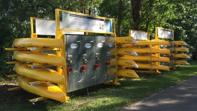
 The NPS kayak rental station located in the Mississippi National River and Recreation Area. The paddle share links to Nice Ride bike share stations, enabling visitors to use the kayaks without needing a car to shuttle between the launch and end points. (Source: Volpe)

Since 2014, the Volpe Center has been working with the National Park Service (NPS) and several local and state partners to create a first-of-its-kind kayak rental or “paddle share system” in the Mississippi National River and Recreation Area (MISS). In August, the system launched and garnered a significant amount of media attention, five-star reviews from users on social media, and inquiries from other areas across the country that would like to create a similar system
The first installation of the system is along a 4-mile stretch of the Mississippi River in North Minneapolis, one of the city’s underserved neighborhoods. The paddle share increases access to the river for people who do not own their own equipment and eliminates the use of a car as a shuttle between where people put in and take out the kayaks. The paddle share supports MISS visitor experience goals, which are to increase access to the river while promoting active transportation.
The current system has two 8-kayak rental stations at North Mississippi Regional Park, one 8-kayak rental station at the Mississippi Watershed Management Organization 2 miles down river, and two 16-kayak return stations 2 miles farther down the river at Boom Island Park. Two 8-kayak rental stations opened in October in a separate location at Bohemian Flats in the Mississippi Gorge Regional Park. All paddle share station locations are adjacent to Nice Ride Minnesota bike share stations so that people can get to their put in location, and to wherever they want to go after they take out, without having to use their car.
To use the paddle share kayaks, people logon to www.paddleshare.org (a website Volpe designed and created for the project) and select a kayak and timeframe to paddle down the river. After completing an on-line reservation, they are emailed a code that they then enter into a locker at the paddle share station at the selected time. The locker contains a paddle, two sizes of life vests, and a mechanism to unlock the kayak. The user then takes the kayak down to the river and enjoys their paddle through an urban yet scenic stretch of the river. At the end of their journey, the user puts the kayak on a rack. As is the case with bike share systems, kayaks are repositioned between racks as necessary.
The Volpe Center has helped NPS to bring together partners, develop an operations plan and budget, and create maps, signs, and the website to support the project. Project staff hope that the paddle share system, which may expand, will succeed in getting more people on the river in the Twin Cities and at other rivers and lakes in public lands across the country in years to come.
Project Contact: Ben Rasmussen
 A typical “dashboard” view from a RIP data collection on Merritt Island, NWR
The US Fish and
Wildlife Service (“FWS” or the “Service”) is tasked with working with others to
conserve, protect, and enhance the habitats for fish, wildlife, and plants for
the continuing benefit of the American people. One of the largest landholders
in the United States, FWS manages over 560 national wildlife refuges, 70
national fish hatcheries, 38 wetland management districts, and other protected
areas. FWS is currently working with the Volpe Center to examine and possibly
update its methodology for collecting data on the condition of its roads,
trails, parking lots, and other transportation assets. The FWS uses the Road
Inventory Program, or RIP, to collect data on these assets. The Federal Highway
Administration (FHWA) manages data collection for the RIP. Together, FWS and
FHWA have made some significant changes to the RIP, resulting in the need for
data clean-up to prepare for on-site condition assessment.
With more than 40 million visitors to Service-managed areas
each year, the FWS needs to manage its roads, trails, and other facilities
efficiently to guarantee safe, reliable, and pleasant access, within the means
of a finite budget. The FWS uses its Service Asset Maintenance Management
System (SAMMS) and Service Application for Material Inspection (SAMI) databases
to continually record and track the conditions of refuges and their facilities
like buildings, roads, and trails.
Over time, these data have grown more complex, leading to
inconsistencies and greater opportunities for reporting/recording errors by
contractors and database managers. At the same time, FWS has increasingly
integrated more of its deferred maintenance and financial systems within SAMMS,
making a clean-up of the transportation data in SAMMS even more critical. Volpe
staff have joined FWS refuge managers and transportation coordinators to
support the RIP by performing a one-time clean-up of the data in SAMMS, region
by region. At the end of the data clean-up, Volpe and FWS staff will examine
how the recurring refuge assessment and review process can be improved over
time.
For administrative purposes, FWS lands are organized into
eight geographic regions; this year Volpe is partnering with the FWS in the
Midwest and Southeast regional offices to clean-up existing RIP data and to
streamline the RIP process itself. Volpe staff are joining FWS transportation
coordinators for interviews with refuge managers and contractors to assess
transportation assets (by physical condition, frequency of use, maintenance
requirements, etc.), to enter and update data in SAMMS, and to ultimately study
which aspects of the process have the most potential for improvement. Volpe and
FWS transportation coordinators will also conduct interviews with refuge
managers and FHWA partners to find opportunities to improve data collection and
identify specific transportation needs at FWS units. By improving the data collected and making suggestions for
improving the data management processes necessary for refuge access, Volpe will
help FWS better improve access to and enjoyment of public lands for millions of
Americans.
Project Contacts: Ben
Rasmussen, Peter Tomczik, and Anders Kosnett
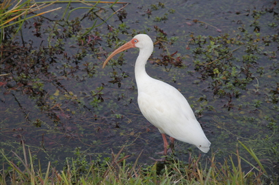 Wildlife at Big Cypress National Preserve. (Source: Volpe)
Air tours over national parks offer
dramatic aerial views of water and land features that are uniquely different
from ground or sea experiences. Nationwide, commercial air tour companies
conduct nearly 300,000 tours over national parks annually. The tours can be
noisy for visitors and wildlife below. The tours are therefore managed to
protect park resources and visitor use without compromising aviation safety or
the nation’s air traffic control system.
Since 2001, the Volpe Center has been working with the Federal
Aviation Administration (FAA) and the National Park Service (NPS) in the
development of air tour management plans (ATMP) and associated environmental
compliance. The FAA Reauthorization and Reform Act of 2012 amended air tour
management law to allow the FAA, NPS, and commercial air tour operators to
voluntarily enter into air tour management agreements under certain
circumstances as a less time-consuming alternative to developing ATMPs. An air
tour management agreement is a park-specific voluntary agreement that manages
commercial air tour operations over a park to protect wildlife, natural and
cultural resources, and visitor use of the park without compromising aviation
safety or the air traffic control system.
Recently, the Volpe Center supported the development of air tour
management agreements at Big
Cypress National Preserve and Biscayne National Park. Through coordination with NPS, FAA, and park
unit staff, the Volpe Center assessed the environmental effects of air tours on
the parks’ resources, including
wildlife, visitor use, wilderness, and culturally sensitive areas. In addition,
the Volpe Center conducted noise modeling, and the results were reviewed to
ensure that the park’s management objectives would continue to be met.
As a result of the environmental review, current air tour routes
were modified to further avoid impacts on sensitive resources. Specifically,
the Volpe Center worked with NPS Night Skies and Natural Sounds Division, as
well as park staff, FAA and the air tour operators to establish conditions for
air tours over Big Cypress National Preserve and Biscayne National Park
including routes, altitudes, number of flights, type of aircraft, hours of
operations, and reporting requirements. The agreements also include a section
that identifies management issues that must be addressed, such as tribal uses,
wilderness restrictions, sensitive habitat, and private property ownership. As
part of the agreement approval process, the Volpe Center supported public and
stakeholder outreach activities, including a public comment period on each
agreement and tribal coordination.
Air tour management agreements for Big Cypress and Biscayne were
successfully executed in 2016. As the
requirements for ATMPs has been underway for 16 years without an agreement
document, this execution of agreements over two parks shows compliance with the
law and that agreements can be achieved.
Project Contact: Becky
Blatnica
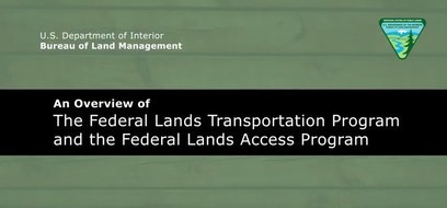 A screenshot of the training video on the FLTP and FLAP funding programs.
Managing over 200 million acres across the western United States, the Bureau of Land Management (BLM) has struggled to educate hundreds of field staff about new funding opportunities available via the Federal Lands Transportation Program (FLTP) and the Federal Lands Access Program (FLAP). Most field staff have little to no experience with transportation, yet they play critical roles in determining transportation needs and forging partnerships with neighboring landowners and governments.
To address this need, the Volpe Center produced a video on the FLTP and FLAP programs, focusing on how the BLM can benefit from the programs and how field staff and partners can get involved. The video uses simple language as well as photos and video footage focusing on BLM lands. In addition, the video caters to both BLM staff and their partners at local governments or neighboring land management agencies by providing tailored suggestions for how to get involved and learn more about these funding programs. The video is available at: https://youtu.be/Ztj_U8oUW9M.
Project Contact: Haley Peckett
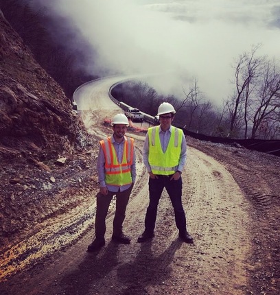 David Daddio (left) and Logan Nash at a construction site for the Foothills Parkway (Great Smoky Mountains National Park).
What public lands
projects are you working on now?
I manage Volpe portfolios with the
National Park Service (NPS) Transportation Branch, National Capital Region, and
Southeast Region. Major initiatives with these offices include linking project
selection and performance management, technology implementation, alternative
transportation planning and feasibility studies, congestion management, and
safety. One of my big charges is to help NPS access federal aid funding and
meet generational funding challenges that are outside of the agency’s normal
appropriations. Through capacity building and technical support, our team has
helped NPS
“open the door” to federal aid programs and transportation partnerships
which is creating real results, both large and small. Recent successes include
supporting the funding strategy to bridge Florida’s U.S. Highway 401/Tamiami
Trail and restore natural water flows to Everglades National Park, building
partnerships with Tennessee DOT to complete select sections of the Foothills
Parkway after 70 years of planning, and leveraging funding to rehabilitate the
Arlington Memorial Bridge, a major gateway between the Commonwealth of Virginia
and the nation’s capital.
What types of
projects outside of public lands do you work on?
I have worked with the Office of the Secretary and Federal
Highway Administration on pedestrian and bicycle safety, accessibility, and
performance management. Most recently, we supported a DOT-wide effort to
understand how federal policies promote and support automobile Level of Service
measures. The way transportation professionals measure and communicate
congestion and automobile delay have important implications for community
livability, modal choices, and the performance of the transportation system.
What are your fondest
memories of public lands?
As an undergrad, I spent two summers working with the Wasatch-Cache National Forest in the
Uinta Mountains near Park City, Utah. I came across the positon through the
Student Conservation Association and split my time there between coordinating
volunteer service projects and making visitor contacts in the High Uintah
Wilderness. Having grown up in Maryland, my conception of the outdoors and public
lands was limited to local parks and places like Acadia and Shenandoah. I had
never been to a designated wilderness, climbed a 13,000-foot mountain, or seen a
slot canyon or the desert. I had the opportunity to visit many national parks
from Yellowstone to Canyonlands and Zion during this time. This position
cemented my passion for public lands and gave me a newfound appreciation for
the vastness of the American landscape.
What new public land
have you discovered since working at Volpe?
The Wichita Mountains Wildlife Refuge near Lawton, Oklahoma,
really made an impression on me. Like many National Wildlife Refuges, Wichita
Mountains combines dramatic scenery with critical wildlife conservation
activities. It was really a privilege to help refuge staff plan
for strategic transportation and recreation improvements while protecting
this valuable resource.
What’s the most
unique, interesting, or strangest job you had before working at Volpe?
After undergrad I worked for the Trust for Public Land, which is a nonprofit
that assists public agencies in acquiring land for conservation and public use.
This position gave me exposure to the financial, political, and regulatory
challenges that federal land management agencies face in achieving their
mission. It also taught me that these agencies rely on the flexibility and
technical expertise of partners to overcome these challenges.
If you were to have a
job that wasn’t transportation or public lands related, what would it be?
My wife tells me I should start a plant nursery or
landscaping business. Since purchasing our first house last year, I have spent
a lot of my free time overhauling the yard at the expense of other seemingly
more critical projects inside the house.
|