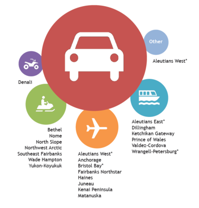
 Alaska boroughs for which automobiles are the leading cause of transportation-related fatalities. Secondary causes are represented by the smaller circles. (Source: Volpe). *Thesse boroughs or census areas have two accident types tied for the first or second most common type of transportation accident.
Transportation in Alaska is unique because
travelers use a diverse set of modes to navigate wild and undeveloped
landscapes. Beyond automobiles, Alaska residents use snow machines, off-highway
and all-terrain vehicles, small planes, and marine transport for both
recreational purposes and as critical forms of transportation.
Over the last several years, the Volpe Center has been
working with Federal Land Management Agencies (FLMAs) in Alaska to characterize
transportation safety issues. This work supports implementation of the Alaska
Federal Lands Long Range Transportation Plan, completed in September 2012 by
the Bureau of Land Management, National Park Service, U.S. Fish and Wildlife
Service, and U.S. Forest Service, in partnership with the Alaska Department of
Transportation and Public Facilities and the Western Federal Lands Highway
Division.
Previous efforts to quantitatively characterize safety
issues have been challenged by Alaska’s wide range of modes and inconsistent
and/or incomplete data. Safety data provided by state or federal transportation
agencies typically focused on particular modes, lacked geographic detail,
and/or focused on certain types of safety issues. At the same time, these data
sets did not indicate whether transportation-related accidents or fatalities
occurred on or off federal lands, and most data was associated with large
jurisdictional boundaries rather than specific locations. Combining data from
multiple data sets resulted in duplicate entries that would have been difficult
and time consuming to prepare for analysis.
The Volpe Center overcame these issues by identifying
multimodal data for transportation injuries and fatalities in two unlikely
places: the Alaska
Department of Health and Social Services Trauma Registry and the Alaska
Department of Health and Social Services Bureau of Vital Statistics. With
no duplicates and minimal data manipulation required, the data provided all the
information needed to complete the analysis. The resulting products from this
work included maps, charts, and infographics that are aiding decision makers in
characterizing transportation safety in Alaska. FLMAs, in partnership with the State,
are using the information to target safety issues in specific locations, devise
and implement countermeasures, and eventually to measure the impact of these
safety improvements.
Project Contact: Alex Linthicum
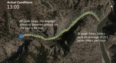 Model results using trail counter data illustrate actual visitation conditions for Hanging Lake recreation site (Source: Volpe)
Since 2013, the Volpe Center has been working
with the U.S. Forest Service (USFS) to develop and implement transportation
solutions for the White River National Forest’s Hanging Lake recreation site
near Glenwood Springs, Colorado. The
trail to this extremely popular tourism destination culminates at Hanging Lake,
which was formed by travertine deposition, a type of limestone, and contains an
environmentally-sensitive hanging-garden plant community. In 2015 close to
150,000 visitors hiked the 1.2 mile trail. With an increase in visitation, resource
and public safety challenges also increase. In an effort to minimize trail
crowding, parking lot congestion, resource degradation, and public safety
incidents, the USFS requested the Volpe Center’s expertise to conduct a
carrying capacity analysis to estimate the number of visitors the site can
sustainably accommodate without detrimentally impacting the environment and
visitor’ experience as it works toward implementing a capacity management
system (CMS).
To perform the capacity analysis, the Volpe Center first
conducted on-site counts and observations of visitors, providing estimates of
several factors, including average vehicle occupancy, average length of stay
per vehicle, average hiking time, and arrivals by bicycle and pedestrians.
Using these estimates, the Volpe Center created a model that mimics the
roundtrip flow of visitors on the trail.
Advancing this analysis, the Volpe Center used trail counter
data from summer 2015 to create a model that can be used to illustrate actual
conditions. In coordination with the USFS and an interagency stakeholder group,
the Volpe Center used the model to develop three capacity scenarios that manage
hourly visitation:
- Physical Capacity Scenario assumes that
every parking space would be filled and the current volumes of bicyclists and
pedestrians continue to visit throughout the trail’s operating day (7:00 AM to
5:00 PM);
- Slight Restrictions Scenario reduces the
Physical Capacity Scenario by 30 percent; and
- Environmentally-Sensitive Scenario
reduces the Physical Capacity Scenario by 60 percent.
The results of the model were used to develop videos that
create an easy way to understand the movement of visitors on the trail (see
figure above). Click
here to view one of the videos.
This information, together with results from a National Park
Service ecological study, a transportation feasibility study, and conversations
with stakeholders and the public, will help inform the USFS in their
environmental analysis as it moves toward implementing a CMS. The Volpe Center
presented these carrying capacity analysis results to Hanging Lake stakeholders
in April 2016 and will continue to work with the USFS to develop a CMS, which
may include a shuttle service to the site.
Project Contact: Ben Rasmussen
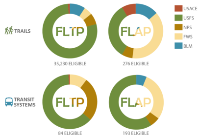 A summary of Federal Lands Transportation Program (FLTP) and Federal Land Access Program (FLAP) eligible transit and trail projects derived from the Multimodal Catalog. (Source: Volpe)
How can Federal Land Management Agencies (FLMAs) attract millennials,
city dwellers, and international visitors? By offering access to their lands
via multimodal transportation, FLMAs provide more options and better access for
these and other visitor groups. However, since most FLMAs lack complete and
robust data on transit and trail systems, they may not fully consider these
multimodal systems as part of transportation planning and programming process,
including partnership development.
The Federal Lands Multimodal Catalog is the first inventory of all
existing and programmed multimodal systems across the country that provide
access to or fall within federal lands. The database will assist federal
agencies, state DOTs, and local governments with planning, performance
management, and project prioritization.
The Volpe Center has been working with FLMAs and their partners to
aggregate data. Now, after two years, the Catalog is ready for use as a
planning tool. The data is available as a Microsoft Access database, with
simple query forms available for transit and trails. With 42 available data
fields, FLMAs can create custom queries to help their staff identify transit and
trail systems in their agencies and regions. The Catalog is meant to be a
living document, so as FLMAs and their partners use it and provide new data,
the Volpe Center will work with FHWA to make updates to improve the Catalog’s
accuracy and completeness.
The Catalog features systems owned by FLMAs, as well as those owned by
state and local governments, transit agencies, and private businesses. This
first iteration of the Catalog is a broad view of how visitors can (and do)
access federal lands by foot, bus, train, and bicycle. The Volpe Center is
pursuing a second phase of the Catalog to add geospatial references, including
transit stop and schedule information through General Transit Feed
Specification (GTFS) data. To enhance its usefulness, the Catalog data may
eventually be integrated into FHWA’s online mapping tools and integrated into
trip planners.
The Catalog is available for download on the FHWA
website.
Project
Contact: Haley Peckett
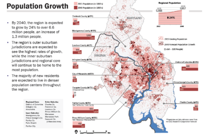 Population growth forecast for National Capital Region through 2040. (Source: Metropolitan Washington Council of Governments)
Scenario planning has become an important transportation
planning technique, particularly for long range transportation planning (LRTP)
and visioning to broaden views of what the future may hold. The National Park
Service (NPS) LRTP
Program is currently piloting the use of scenario planning techniques as
part of the National Capital Region (NCR) LRTP development process, an effort
influenced by recommendations presented by the Volpe Center from two white
papers. This pilot seeks to inform the NCR LRTP by departing from
path-dependent thinking, such as simply assuming that current trends and
forecasts will continue over the life of a 20 year plan. Instead, NPS is using
scenarios to envision different possible outcomes and make more informed
decisions.
The NCR LRTP scenario planning pilot uses an exploratory
approach, in which driving factors of future conditions (such as population
changes, job growth, and advancing vehicle technology) are identified through
stakeholder workshops and background research, and then used to produce
narratives of four potential futures. These future scenarios, in addition to a
“base case” representing current forecasts and trends, can then be used by the
LRTP team to inform plan objectives and “test” potential strategies.
The goal of the scenario planning process isn’t to choose a
desired future; rather, it is to identify management actions that could perform
well in multiple scenarios regardless of what the future holds. After all, some
have called the smartphone the most significant transportation innovation of
the 21st century, but few LRTPs had the broad vision to anticipate
the effects disruptive technologies could have on the ways people plan their
travel. Scenario planning is one way that NPS is working to prepare for these and other potential changes in order to
craft a more comprehensive LRTP.
A second LRTP scenario planning pilot is also underway at
Denali National Park and Preserve, with support from the Western Federal Lands
Highway Division Office of the Federal Highway Administration, the NPS Alaska
Regional Office, the Volpe Center, and others. If successful, the NPS LRTP
Program hopes to integrate scenario planning into future LRTPs as a best
practice, when relevant.
For more information, visit the NCR LRTP
Scenario Planning Environment and Public Comment site.
Project Contact: Kevin McCoy
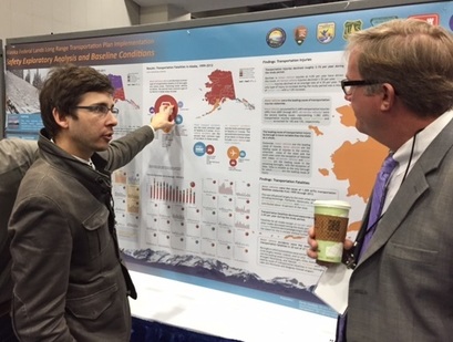 Alex Linthicum discusses safety performance measures for Alaska LRTP. (Source: Paul Schrooten, National Park Service)
Each January, thousands of transportation
professionals from around the globe gather in Washington, D.C. to share and
learn about the most recent and innovative research going on across the
industry to make the transportation system the best it can be.
Volpe’s Public Lands Team was well represented among the
thousands of sessions organized during the 95th annual meeting, which
took place January 10-14, 2016.
Ben Rasmussen discussed his work on integrating
greenhouse gas reduction and climate change adaptation strategies into state
and regional transportation planning. Together with co-authors Aaron Sussman
and Chowdhury Siddiqui, Ben was also awarded Best Paper by the Special Task
Force on Climate Change and Energy for his paper titled “Integrating
Climate Change into Scenario Planning: Can Mitigation Measures also Make a
Region More Resilient?”
Michael Kay and Erica Simmons presented a poster on
their ongoing work on the Pacific
Northwest Collaborative Long Range Transportation Plan (CLRTP) for Oregon
and Washington. The CLRTP is policy-level plan for all FLMAs to plan and manage
their transportation systems over the next twenty years. The groundwork
provided by this effort will inform future CLRTPs for other regions across the
county.
Alex Linthicum
presented a poster showcasing
his work on safety performance measures for the Alaska Federal Lands Long Range
Transportation Plan. Details on this project are provided in a feature article above.
Logan Nash gave a
presentation
on his ongoing work advancing the development of digital transit
information for national park visitors. Working with NPS on a pilot, Logan is
illustrating how sharing transit schedules in an open data format enables the
agency to integrate transit trip planning features into its redesigned map-focused website, and also opens the possibility of
third-party app developers, such as Google Maps, sharing public lands transit
schedules. A goal of this work
is to showcase the potential use of open data for other FLMAs.
Margaret
Petrella and Lauren
Deaderick presented a poster on
their work developing a Collaborative Visitor Transportation Survey toolkit to
be used by FLMAs to support transportation research. In partnership with the FHWA
Western Federal Lands Highway Division, this effort helps to streamline data
collection processes and increase collaboration among FLMAs to support long
range transportation planning, including the analysis of performance metrics
that will inform transportation improvements.
 Logan enjoying a trip with his girlfriend, Yilu, to Great Falls National Park outside Washington, D.C. (Source: Volpe)
What public lands
projects are you working on now?
I am working on a number of projects for the U.S. Forest
Service (USFS) and the National Park Service (NPS), and I’m particularly
excited about some current efforts with both agencies to use technology and new
data sources to enhance public lands transportation. One example with the USFS
is that our team is exploring potential agency uses of unmanned aerial vehicles
(UAVs or “drones”) for infrastructure inspections and other activities. For
NPS, we are working on a pilot release
of digital transit
schedule data for select park transit systems. This will allow the parks to
map stops, routes, and departures on their own websites while enabling third
parties like Chimani and Google Maps to integrate NPS transit into their own
apps. The first feeds are launching this summer!
What types of
projects outside of public lands do you work on?
I help coordinate the U.S. DOT’s Transportation Data Forum,
a collaboration with the Bureau of
Transportation Statistics and the Office of the
Secretary of Transportation. The forum is a series of conversations with
different DOT modes to engage with each other about emerging ways to manage,
visualize, and make use of the many data sources available to us. The goal of
using and sharing data to benefit agency missions is a rapidly-developing
priority for all government agencies.
What are your fondest
memories of public lands?
I grew up in east Tennessee, and visits to Great Smoky Mountains National Park
with my dad were a highlight. We liked to visit the “locals” entrance near Townsend,
TN, and he kept a hand-annotated map of driving directions to our favorite
trail. It had directions like “turn right at the old cemetery” and notes about
the best diner to stop at nearby. There are so many great ways to plan your
public lands trip using an online map these days, but it is hard to recreate
that charm!
What new public land
have you discovered since working at Volpe?
Last fall I was on a Transportation Assistance Group (TAG)
to Santa Fe National Forest in
New Mexico. Being an easterner, I was completely floored by the “big sky”
panoramas, as well as the unique heritage of that area (not to mention the
food!). By the time I returned home I was already dreaming up plans for a
future vacation!
What’s the most
unique, interesting, or strangest job you had before working at Volpe?
I was a part-time sales associate at Bath and Body Works
during high school. The characteristic in-store sickly smell of
all-possible-scents-mixed-together still makes me want to run and open a
window.
If you were to have a
job that wasn’t transportation or public lands related, what would it be?
After college, I flirted with the idea of going
into academic history. History is still something I enjoy, but part of my rationale
for pursuing my current career is that it’s much easier to be a hobbyist
historian than it is to be a hobbyist transportation planner.
|