U.S. Geological Survey sent this bulletin at 07/29/2026 11:11 AM EDT
July 29, 2026
Latest Annual NLCD 1.2 Release Adds 2025 Data
June 30, 2026 — The latest version of the Annual National Land Cover Database (NLCD) Conterminous U.S. (CU) Collection 1.2 adds 2025 to the temporal extent. Annual NLCD extends back to 1985 for a total of 41 years of land cover dynamics based on Landsat satellite data.
Annual NLCD provides six products: Land Cover, Land Cover Change, Land Cover Confidence, Fractional Impervious Surface, Impervious Descriptor and Spectral Change Day of Year.
Building on what was already the definitive land cover resource for the United States, Annual NLCD debuted in October 2024 to provide yearly updates. Data for 2024 was added in June 2025. Novel deep learning techniques have made the production process more efficient while maintaining accuracy.
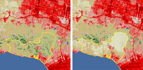
Before (2024) and after (2025) Annual NLCD Land Cover images of the January 2025 Palisades Fire in the Los Angeles, California, area. The yellow outline represents the fire's perimeter. The light tan color indicates grassland; medium brown is shrub/scrub land cover such as chapparal; shades of green are forests; and shades of red are developed cities and roads, with darker shades indicating more intense areas of development. Dark blue is open water, including the Pacific Ocean at the bottom left. A considerable amount of the shrub/scrub and evergreen forest areas within the fire perimeter was classified as grassland after the fire.
Faces of Annual NLCD
This feature introduces you to people at the USGS Earth Resources Observation and Science (EROS) Center who work to deliver updates to Annual NLCD.
Tell us a little about your work on the Annual NLCD project.
I co-lead Research and Development for Annual NLCD. I develop methods for change detection, using the full Landsat time series to determine when broad changes are occurring, particularly abrupt changes.
How does the change detection algorithm work?
It uses multiple Landsat bands to see when there’s a significant change from the previous trend, and that’s what we consider a change for the purposes of the algorithm. For example, if there’s a forest fire, then after the forest fire, ideally the algorithm will detect approximately when the fire burned in that particular pixel location. It’ll detect the change when the forest converts to not treed anymore—from tree to grass. But if it’s a low intensity fire, the algorithm might potentially capture where not all of the trees are killed. Then it’s a change but not a cover change because it stays forest.
How are you trying to improve change detection?
The specific algorithm we’re using for Annual NLCD, Continuous Change Detection or CCD, we’ve re-coded to make it more efficient. We’ve been working on tweaking it and wrote a paper with a version that has a somewhat different statistical method for detecting whether there’s a change.
How does the algorithm help add years to the Annual NLCD dataset?
A lot of change detection algorithms work pretty well in the middle of the time series, but toward the end they behave somewhat differently. The CCD algorithm works in a continuous way, looking a bit forward but not a lot forward. The big advantage of that for an operational product like NLCD is that we can run that to the end of the data we have, and then we’re able to pick that processing back up when we want to extend the time series and have it be consistent with what came before without anomalies at the end. To incorporate algorithm improvements, we do intend to occasionally go back and reprocess everything, but the users don’t want to have the entire record change every time we add a new year, and we don’t want to do that either. So having the change detection extending through the new period while being as continuous as possible is very helpful.
What do you like best about what you do?
There’s a lot to like, trying to solve interesting problems and improving on an interesting algorithm. And then of course there’s great people to work with.
What are some examples of change you find interesting or fun to look at?
That’s a hard question because one of the powerful things about Annual NLCD is that it is applicable for a wide variety of use cases. I find some of the urban growth to be quite interesting. Forest fires and other tree changes are widespread and important to understand. And sod farms look more different than anything else on the change detection algorithm. They’re green grass, and then you take up the grass and it’s bare dirt. And they do it pretty regularly.
What are you excited about for the future of Annual NLCD?
There’s a lot of things that I’m excited about going forward. We have the length of the Landsat archive that’s the foundation of Annual NLCD, and then the new bands and higher spatial resolution coming up for Landsat 10. I think different bands will apply in different types of land covers.
Plans for Hawaii and Alaska Annual NLCD Data Releases
Annual NLCD addition of Hawaii and Alaska: Work is under way! Hawaii’s data release is currently expected in December 2026 and Alaska’s by mid-2027.
Ongoing Weekly RCMAP-EAG Estimates
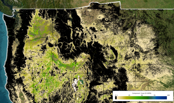
Maps showing near-real-time weekly estimates of Exotic Annual Grasses (EAG) and total herbaceous cover are in production by the Rangeland Condition Monitoring Assessment and Projection (RCMAP) team. Improvements have been made to the mapping method, and maps will be released weekly through the end of September. The graphic above shows the estimates of cheatgrass cover from a recent week this summer.
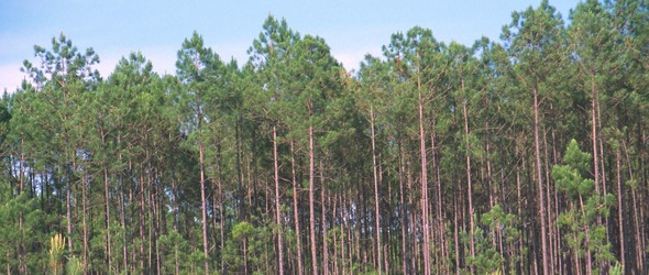
Visual stories explore specific areas of land change in the United States and the causes of those changes. Examples include shifting forests in Georgia (photo above), oil-related growth in North Dakota, and phosphate mining in Florida.
We would love to hear what you’re doing with NLCD, RCMAP, EAG or other land cover data. The variety of uses continues to amaze us! Email us about it at nlcd@usgs.gov.
Catch Up on Past Newsletters
Are you a newer subscriber who would like to browse our previous newsletters? That's easy to do!
Social media updates about USGS Land Cover have moved to the USGS EROS social media accounts. Be sure to follow EROS on X (formerly Twitter), Facebook and Instagram for information on upcoming data, tools, services and publications.
Have questions about Annual NLCD or other land cover products? Email nlcd@usgs.gov.