|
❄️ Winter with the USGS Water Science School ❄️
As winter winds down and we look ahead to spring, the USGS Water Science School is here to support K-12 teachers with engaging water science resources.
From snowmelt and ice to the first signs of seasonal change, it’s a great time to connect your students with the science happening all around them. Whether you’re planning next semester’s lessons or exploring new ideas, the USGS Water Science School offers a wide range of tools to enrich your teaching.
📬 Thanks for being part of our growing educator community, let’s keep the learning flowing!
|
|
Snowmelt isn’t just a seasonal change in the mountains, it’s one of the most important drivers of water availability in the Western United States. When snow melts earlier or in smaller amounts, it can dramatically alter streamflow, affecting ecosystems, agriculture, and the water supplies that millions of people depend on.
For educators, this creates a powerful opportunity to connect real world climate and water challenges with classroom learning.
Through monitoring of snowpack, snow water equivalent, and melt timing, the USGS provides data that help scientists understand how warming temperatures are shifting the timing and volume of snowmelt. These datasets are essential for identifying changes in water availability and anticipating downstream impacts.
Students and educators can explore how snow becomes streamflow through interactive data stories developed by the USGS VizLab, using real measurements to visualize how changing snowmelt shapes rivers, landscapes, and communities.
🔎 Explore the Science
From Snow to Flow - What changing snowmelt means for Water in the Western U.S. Explore how winter snow accumulation as well as spring snowmelt affect streamflow and water availability for the rest of the year.
🧪 Classroom Connection: Try This Activity
Wondering how to bring this data into your classroom? Try this hands-on activity from the Water Science School that helps students investigate how changing snowmelt affects water in the western U.S.
📘 Explore the activity: How Changing Snowmelt affects Water in the Western U.S.
|
|
|
Groundwater Awareness Week
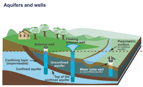
March 8th - 14th is Groundwater Awareness Week! Groundwater is one of our most important and often unseen, water resources. There is water beneath our feet no matter where we live, moving slowly through layers of rock, sand, and soil and supplying drinking water, streams, and ecosystems.
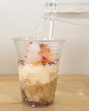
To help students explore how groundwater is stored and how it moves through aquifers, the Water Science School is featuring our hands on (and delicious!) Edible Aquifer activity. This classroom friendly model lets learners build their own aquifer using simple ingredients while discovering how water flows underground, how aquifers differ, and how contamination can spread.
Activity: The Edible Aquifer
Grade Level: 4–8
Time: 20 - 30 minutes
Objective: Students will learn and model how groundwater moves through aquifers, how contamination spreads, and compare confined vs. unconfined aquifers using an edible model.
Materials
*Choose one material to represent each bolded element. This activity is designed so you can choose ingredients that fit your needs (healthier, allergy‑friendly, or availability).
- Clear cups
- Straw or pipette
- Spoon
- Rocks/gravel - berries, grapes, nuts, chocolate chips, gummy bears, fruit snacks
- Sand – crushed cereal, crushed cookies, crushed graham crackers
- Clay – yogurt, mashed bananas, peanut butter, marshmallow fluff, pudding, ice cream
- Unsaturated zone materials - ice, apples (cut into chunks), freeze dried fruit
- Soil/ land cover – granola, sprinkles
- Groundwater - milk, white grape juice, clear soda, water
- Contamination – food coloring, cocoa powder, kool-aid powder
Alternative, Non-Edible Aquifer: If you prefer a version that doesn’t involve food, you can build a simple aquifer model using the element materials listed above.
|
 |
|
Procedure
Each group should built at least build two aquifer models, one confined and one unconfined, to observe differences in water movement, storage, and vulnerability to contamination.
Visit the Water Science School to explore the activity: The Edible Aquifer
|
|
|

In this issue we here from High School Science Teacher Sarah Fulmer who teaches at Anoka High School in Minnesota.
Ask any 14- or 15-year-old where their drinking water comes from, and many will simply say, “the sink.” If pressed, they might add that their pipes draw from the local water tower. For most students, this is the extent of their knowledge regarding their daily water source. To bridge this gap, my colleagues and I developed a curriculum designed to help students trace their water back to its true origin, which, in Minnesota, is primarily groundwater.
We begin the unit using physical models to visualize surface runoff, using these observations to build a working definition of a watershed. After exploring the factors that influence a community's water supply, we dig deeper into how water is stored underground. Through inquiry-based activities, students discover the diverse earth materials beneath their feet, leading them to grasp the critical concepts of porosity and permeability. Once they understand what makes a functional aquifer, they use mini-models to identify its various components.
The unit also tackles the complexities of contamination. Through hands-on labs, students gain insight on vocabulary of pollution, identifying contamination plumes, point sources, and nonpoint sources. For their summative project, students are given the role of environmental consultants for a fictitious town. They must present a report detailing how a specific contaminant affected the town’s aquifer and propose an evidence-based clean-up plan.
By prioritizing hands-on exploration, my colleagues and I transform a potentially "boring" topic into an engaging scientific investigation. My hope is that when these students are asked about their water in the future, they can provide a much deeper response than just "the sink.
- Sarah Fulmer
|
|
|
The USGS’s Virtual Classroom Visits (VcV) program connects our scientists with classrooms across the Nation, through virtual meeting technology. VcV allows USGS scientists to pop in to schools that are not just around the corner.
Sign up now!
|
|
|
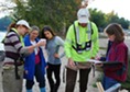
The USGS will be at the National Science Teaching Association (NSTA) National Conference in Anaheim!
Come find us in the Exhibit Hall at Booth #1621
Workshop - Choose Your Own Adventure at USGS! Exploring Free Educational Resources in Earth Sciences Friday, April 17, 2:40 PM - 3:40PM Location: 163, North Building.
|
|
|
|
|
|