U.S. Geological Survey sent this bulletin at 03/03/2026 11:30 AM EST
March 3, 2026
Faces of Annual NLCD
In this and upcoming newsletters, get to know more about the Annual National Land Cover Database (NLCD) through the people at the USGS Earth Resources Observation and Science (EROS) Center who work to deliver the annual land cover and land change updates.
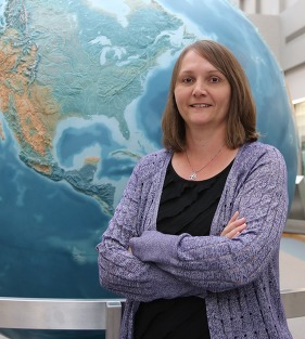
Meet Kristi Sayler, Program Manager (Delegator at Heart)
Tell us, from your perspective, a little about the Annual NLCD project and the work involved.
Annual NLCD is a big beast. A lot of moving parts. A lot of tasks. A lot of products that have to come out. And we want to put out the best product that we can with the most amount of R&D (research and development) that we can. So we're trying to fit all that into our timelines.
What is your role in the project?
My role is to keep things moving forward and make sure we meet timelines and deadlines. I also try to plan for contingencies.
What do you like best about what you do?
Being able to work with all these smart people doing the R&D and keeping things moving. They have such great ideas, and they come up with solutions to problems fast and do it well. The project is the people who are putting in the effort.
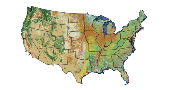
Annual NLCD data covers 40 years of land cover change. What’s a use case of Annual NLCD data that you have found especially interesting?
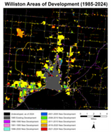
With 40 years of data, we can track a lot of things. Our recent story on the Williston, North Dakota, area really shows how we can track urbanization and do it very well. And in that case, you have a cause and effect that you can tie to it.
What are you excited about for the future of Annual NLCD?
Our next update this summer, Annual NLCD Collection 1.2, will add 2025 information to the record. Now that we've got the method for releases to add a year under our belt, this is kind of the first time we're going to just push the button, so to speak. We're on track for that to go smoothly. And then by the early part of 2027, we hope to have Alaska and Hawaii 1.0 put out, with data from 2000 to 2025.
Annual NLCD 2.0 is already starting to come up in our talks because you’ve got to plan so far ahead. That will be a bigger R&D effort again to make a new generation of improvements.
Anything surprising to share about your work with Annual NLCD?
One of the things is how useful the cloud has been and how we've gotten into the groove of being able to use it effectively and efficiently. That's going to make things easier going forward.
Annual NLCD Collection 1.2 Update for the Lower 48 States: Watch for the next release of Annual NLCD data this summer, which will add information from 2025.
Annual NLCD addition of Alaska and Hawaii: Work is under way, and the data release is expected by early 2027.
RCMAP Update: Look for an update to the Rangeland Condition Monitoring Assessment and Projection (RCMAP) fractional component time-series product suite with 2025 data this spring.
Weekly EAG Estimates: Beginning in April, seasonal weekly fractional cover estimates of exotic annual grasses (EAGs) will be available.
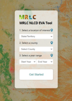
Watch ‘Visualizing Land Cover with MRLC Tools’ Webinar
January 20, 2026 — USGS EROS User Services hosted a webinar spotlighting tools available on the Multi-Resolution Land Characteristics website to help scientists, analysts and others visualize Annual NLCD data.
Annual NLCD Viewer
EVA (Enhanced Visualization and Analysis) Tool
The webinar filled up fast, so for those who didn't get to watch it live, the recording is now available.
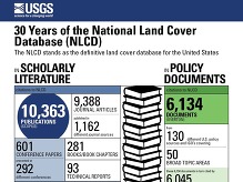
October 1, 2025 — A new publication, "Thirty Years of the U.S. National Land Cover Database: Impacts and Future Direction," spotlighted the widespread use of NLCD, its current improvements as Annual NLCD and its future outlook.
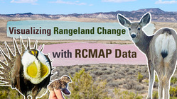
A new video showcasing the capabilities of Rangeland Condition Monitoring Assessment and Projection (RCMAP) data describes how users in a diverse array of fields can apply it to rangeland decision making.
The EROS social media accounts see high interest in topics related to land cover. Here's an example.
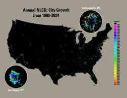
A November 25, 2025, post that showcased the capability of Annual NLCD to show city growth over 40 years across the United States performed well. It reached more than 9,000 people and received nearly 800 engagements. View the post.
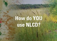
Do You Use USGS Land Cover Products?
We would love to hear what you’re doing with NLCD, RCMAP, EAG or other land cover data. The variety of uses continues to amaze us! Email us about it at custserv@usgs.gov.
Catch Up on Past Newsletters
Are you a newer subscriber who would like to browse our previous newsletters? That's easy to do!
Social media updates about USGS Land Cover have moved to the USGS EROS social media accounts. Be sure to follow EROS on X (formerly Twitter), Facebook and Instagram for information on upcoming data, tools, services and publications.
Have questions about Annual NLCD or other land cover products? Email custserv@usgs.gov.