|
Winter 2026 Newsletter
As we enter 2026, we are continuing to make big changes to how you access USGS water data, including new features, user-centered design, and decommissioning NWISweb. Read on for highlights from the last few months and what’s to come this winter.
Key highlights in this newsletter:
-
Upcoming public webinar: on New Features and NWISWeb decommissioning
-
Now available: Field Measurements
- Spotlight on our users: User-Centered Design for WDFN Multi-locational Functionality
- Decommissioning WaterServices
- Legacy gwlevels pages are now frozen
- NWIS Decommissioning Campaign 2 is in full swing!
- New blog available to download and use USGS Water Data in R with dataRetrieval package
You’re invited to a public USGS Webinar: Water Data for the Nation – New Features and NWISWeb Decommissioning
Join link
January 15, 2026
2pm to 3pm Eastern | 11am to 12pm Pacific
We want to make you aware of some important changes in how we deliver water data. These changes are part of a long-term effort to modernize our Water Data for the Nation (WDFN) systems, improve performance, and better serve both internal and public users.
|
|
|
USGS is phasing out several legacy systems, including NWISWeb, WaterWatch, and WaterServices. At the same time, we’re introducing new, streamlined tools that better support current technologies, cybersecurity, and user needs. The data aren’t changing, but how you access them is.
|
|
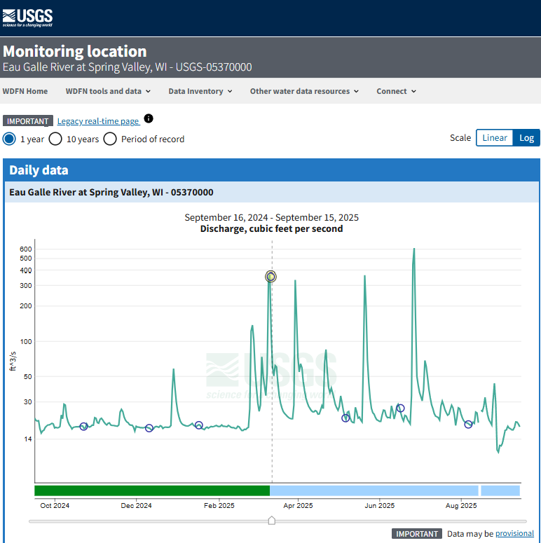
We are excited to announce a new feature on Monitoring Location pages that provide field measurements. Field measurements are physically measured values collected by USGS hydrology technicians during a visit to the monitoring location. Field measurements consist of measurements of streamgage height, discharge, and groundwater levels, and can be used as calibration readings for the automated sensors collecting continuous data.
|
|
User-centered design is a process where we focus our designs based on the context and the needs of our users. We involve users throughout our agile and user-centered development process. The core principles of user-centered design are to learn about the users, build for their needs, and refine your designs based on their feedback.
We conduct discovery research through a process called a path analysis, which helps us understand the problem space and identify a path forward by surveying our users. The goals of the WDFN multi-location path analysis were to understand who uses the functionality, why they use that functionality, and prioritize features to include in the modernized webpages. We spoke with dozens of users including emergency managers, canoe and kayak enthusiasts, USGS hydrotechnicians, river restoration managers, and many others!
Subsequent to the path analysis, we conducted usability tests on early designs of the Combined Location Hydrograph, My Favorites-Graphed, and State Page. Getting feedback before these pages are available on the web is invaluable, and allows us to make quick adjustments, such as changing color, moving buttons, and identifying areas for future improvements.
Interested in participating in user testing? Email
|
|
 |
|
WaterServices APIs will be decommissioned in early 2027
|
We have released modernized which will supersede the WaterServices family of APIs. WaterServices will be decommissioned in the first quarter of 2027. We will have more information about the decommission process, which may include intentional service degradation and blackouts, in the second half of 2026. We will not begin any intentional degradation of these services before August 2026.
To make this easier, we’ve developed extensive documentation for the new APIs, including both and . We’ve additionally developed a which will help users move their applications from WaterServices to the new Water Data APIs.
|
|
|
The "gwlevels" level pages on NWISWeb, which provided graphs of field visit groundwater measurements, have been frozen as of November 18th, 2025. No new data will appear on these pages, and they will be decommissioned in early 2026. These data are available on the modernized Monitoring Location Pages under the "field measurements" banner.
|
|
NWISweb launched real-time data pages in 1995 and today it hosts more than 7 million annual unique visitors, billions of successful page requests, and terabytes of data delivered. After several years of modernization, we are beginning the final decommissioning or turning off of legacy NWISweb webpages held on https://waterdata.usgs.gov. This means that pages that you may have relied on for years are going away.
Over three years, from October 2024 through February 2027, we will decommission NWISweb. We will do this in three targeted campaigns, which will take place between the months of October and February in each year (the lowest web traffic time of the year). We are making extra effort to avoid making changes while there are major water events like floods and hurricanes. By the end of the third campaign in early 2027, all NWISweb pages will be decommissioned and no longer available.
-
NWISWeb Decommissioning Campaign 2 will occur from now through February 2026
-
Decommissioning impacts include waterdata.usgs.gov/ URLs that include: /annual, /monthly, /dvstat, /dv, /gwlevels, /measurements, help.waterdata.usgs.gov, /inventory, /nwis, /rt, /water_use, /wys_rpt
-
WaterWatch and WaterQualityWatch will also be decommissioned
We have recently updated our package dataRetrieval, which simplifies the process of finding and retrieving water data. This new version of dataRetrieval is designed to work with the modernized Water Data APIs and has several benefits for new and existing users:
-
Human-readable function names and arguments written in “snake case” (e.g., read_waterdata_samples())
-
Customized functions for each of the Water Data API services (e.g., latest continuous values) plus a generic function that covers all services
-
The new functions include ALL possible arguments that the web service APIs support
|
|
|
We understand that change can be difficult, and some of these changes may feel sudden. We’re here to help throughout this process. Our team is ready to support your transition to modern tools and workflows.
Contact: wdfn@usgs.gov
|
|
Did someone share this newsletter with you?
Join the Water Data for the Nation community and subscribe to our newsletter today!
|
|
Join our community on social media. |
|
|
|
|