What’s New?
A publication pre-print describing model performance
We recently submitted a paper to the journal HESS describing the performance of the modelling system at 11 camera sites co-located with USGS reference gages in western Massachusetts. We are excited to share these results, which help guide how we communicate the use of this tool. A pre-print of the paper is available here: https://egusphere.copernicus.org/preprints/2025/egusphere-2025-1186/
A growing network
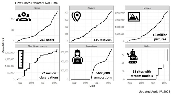
Thanks to federal, state, local, university, tribal, and NGO partners, we now have more than 8 million photos at more than 400 sites and have trained over 60 ranking models. Our USGS camera network is expanding rapidly, including deployments this year focused on studying stream baseflow resilience in the Delaware River basin.
Big “Thank You!” to annotators
Without annotations we wouldn’t be able to train models! So thanks to all who have completed annotations for their sites. We have also had a huge amount of help from high school students from across the country through the USGS STEP-UP program. We are proud of them and very much appreciate all their hard work!! You can read more about the program here: STEP-UP: Secondary Transition to Employment Program – USGS Partnership | U.S. Geological Survey
Testing Methods Developments
We have been experimenting with better ways to do the modeling, including by adding in weather information, testing different types of models, and building models using the images from multiple sites. In general, we find that our original approach is hard to improve upon, giving us confidence to continue with the same methodology. Our web developer and data scientist Jeff Walker produced a summary report that is visible here: https://doi.org/10.5281/zenodo.15133341
|