|
View as a webpage
|
 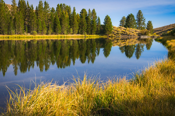 Dynamo Pond, Bishop Field Office
Photo by Jesse Pluim, BLM
|
|
ISSUE 923- October 8, 2020
|
|
|
 |
|
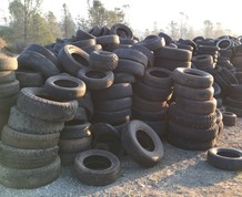
Quite the haul! Over 7K tires collected for recycling!
The Bureau of Land Management, the Tahoe National Forest, Waste Management and Nevada County completed another successful annual Tire Amnesty Week, which allowed Nevada County residents to bring up to 9 tires for free disposal. Typically, between 4,000-5,000 tires are collected, but because so many people cleaned house during California’s shelter-in-place order, residents delivered more than 7,400 tires! Since 2014, the BLM has co-sponsored the event and has helped collect nearly 40,000 tires for recycling.(BLM CA Facebook)
|
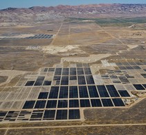
BLM initiates environmental review of two proposed solar projects on public lands in Riverside County
The BLM is seeking public comment on the preparation of an environmental analysis to analyze the potential impacts of approving two solar projects on approximately 2,000 acres of public lands each, in Riverside County. If approved, the Arica and Victory Pass solar projects would result in an estimated combined private infrastructure investment of $689 million, $5.9 million in annual operational economic benefit, and together power approximately 132,000 homes (BLM CA Website)
|

BLM Bakersfield Field Office issues December oil and gas lease sale notice, Kern County
The Bureau of Land Management Bakersfield Field Office is offering seven parcels totaling more than 4,000 acres of Federal minerals for a December oil and gas lease sale. All parcels are in or adjacent to existing oilfields in Kern County. The 30-day protest period ends Nov. 9. (BLM CA News Release)
|
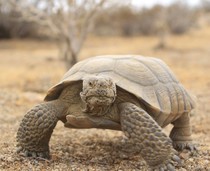
It's Desert Tortoise Week!
Did you know the desert tortoise is the official state reptile for #California? The Mojave desert tortoise, which is a threatened species, is easily frightened by human contact - sometimes a tortoise will become so scared that it urinates, which can result in the tortoise dying of dehydration. If you are lucky enough to see a tortoise in the wild, stay far enough away that the tortoise does not change its behavior - if the tortoise ducks into its shell, you're too close! You and the tortoise will both have a better interaction if you stay at least 20 feet away from it. To learn more, check out this video: The Heat is On: Desert Tortoises and Survival (BLM CA Facebook)
|
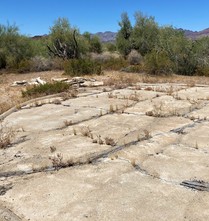
BLM approves project to increase water sources for wildlife in Riverside County
The Bureau of Land Management Palm Springs-South Coast Field Office today announced the approval of the California Department of Fish and Wildlife (CDFW) Small Game Guzzler Enhancement Project, located in eastern Riverside County approximately 75 miles from the City of Blythe. The BLM is partnering with CDFW in their effort to provide permanent, reliable water sources for large game species at five existing guzzler locations. The project includes replacing five existing small game guzzler tanks with larger guzzler tanks and repairing the existing concrete aprons to ensure water can be collected and funneled into the guzzlers when it rains. (BLM CA Website)
|
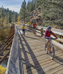
The DOI expands e-bike opportunities to enhance access
The Department of the Interior today announced that it finalized electric bike (or e-bike) regulations that pave the way for land managers to allow more people, especially older Americans and those with physical limitations, to experience bicycling on public lands managed by the National Park Service, the Bureau of Land Management, U.S. Fish and Wildlife Service and the Bureau of Reclamation. Bicycling is an excellent way to experience America’s rich natural heritage, and e-bike innovations in bicycle design have opened the possibilities for a greater number of people, particularly for those with limitations stemming from age, illness, disability or fitness, especially in more challenging environments, such as high altitudes or hilly terrain. (DOI Website)
|
Ranger Tammy and Friends at Ft. Ord
Join Ranger Tammy as she explores Fort Ord National Monument and the many friends that work to make the monument ready for visitors to explore! (BLM CA YouTube) (BLM CA YouTube)
|
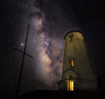
Milky Way galactic core over Piedras Blancas Light Station
The Piedras Blancas Light Station is named for the distinctive white rocks that loom just offshore. These rocks, and the rugged shoreline, are home to seabirds, sea lions and elephant seals. Access to Piedras Blancas is by guided tours only. Tours are offered year-round, and feature cultural and natural history, as well as spectacular scenery. (BLM CA Website)
|
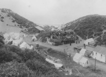
Pt. Sal, once scene of activity for shipping, now is park, rangeland
Point Sal, a nub of land north of Vandenberg Air Force Base, and south of the Guadalupe Dunes was named Point Sal by explorer George Vancouver in 1792 for Hermenegildo Sal, who was at that time commandant of San Francisco. Although there are no facilities on the property, in the intriguing manner of history, there’s always a story behind the story. (Santa Maria Times)
|
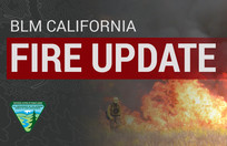
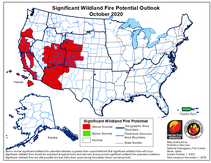
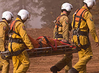
California state fire update
More than 15,000 firefighters continue to work towards containment on 22 major wildfires across the state. Yesterday, firefighters also responded to 23 new wildfires, quickly bringing full containment to all. Since the beginning of the year, there have been over 8,400 wildfires that have burned well over 4 million acres in California. To date, the total number of fatalities statewide is 31 and more than 9,200 structures have been destroyed. Cooler temperatures prevail today in most of the State, and will continue through Sunday. Light rain is possible on Saturday in Northern California. Next week, the return of warm and dry conditions is expected, as well as the possibility of a wind event accompanying the changing weather pattern. California historically experiences some of the most devastating wildfires in the months of September and October. Do not let your guard down! (Cal Fire)
|
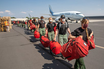
Fighting wildfires while mitigating COVID-19
We can't eliminate risk. We can only mitigate it. We've made great strides making firefighting safer for the wildland firefighting community, & we're showing the same determination as we confront the spread of COVID-19 during FireYear 2020 (BLM Website)
|
NWCG announces the recipients of the 2019 Wildland Fire EMS Awards.
The NWCG Emergency Medical Committee (EMC) annually recognizes individuals and groups who have demonstrated outstanding actions or accomplishments that are above and beyond the expectation of one’s normal job duties or mission. The 2019 awards honor eleven individuals and one crew. Congratulations to the awardees for their exemplary service in the line of duty! (NWCG Website)
|
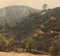
As fires continue, land managers start to survey ecological damage and recovery in Bay area parks
Close to a million acres have burned in the greater Bay Area in the last six weeks, including hundreds of thousands of acres in public parks and protected open spaces. As the Glass Fire continues to burn through several state and regional parks, as well as residential and agricultural areas in Napa and Sonoma counties, land managers and stewards have begun to assess the ecological effects of the massive lightning-ignited SCU, CZU, and LNU Lightning Complex fires. (Bay Nature)
|

For the latest info on current wildfires in CA, visit these helpful websites:
- Inciweb
- Cal Fire
- National Fire Situational Awareness Tool
Remember to follow your local fire & law enforcement agencies on social media for updates specific to your area and heed all evacuation warning & orders.
While fire activity remains high, please visit our social media pages to get the latest fire map every day:
Facebook or Twitter
|
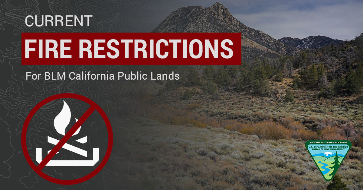 BLM California has issued season fire restrictions due to increased wildland fire danger in the state. Here’s an interactive MAP showing all current fire restrictions. Be sure to bookmark it for future use!
Due to high fire danger, fire restrictions were increased on BLM-managed public lands to prohibit use of all open flames, including campfires, BBQ’s and stoves in Northern and Central California, in addition to the statewide fire prevention order and local district fire and target shooting restrictions. For information about Southern California, see restrictions listed for California Desert District on our Fire Restrictions website: https://go.usa.gov/xGpn8
Seasonal target shooting restrictions are in effect for the Redding Field Office, portions of the California Desert District and all of Central California District. The target shooting restrictions do not apply to individuals with a valid State of California hunting license participating in hunting seasons in areas established by the state.
Panoche and Tumey Hills vehicle closure extended due to fire danger
The Bureau of Land Management Central Coast Field Office will extend the annual vehicle closure for the Panoche and Tumey Hills recreation areas in San Benito County to Friday, Nov. 13, due to extreme wildland fire danger. The vehicle closure may be lifted sooner if conditions allow and fire danger subsides. Both recreation areas remain open for hiking, hunting and bicycling. (BLM CA Website)
|
Berryessa Snow Mountain National Monument and adjacent areas
San Joaquin River Gorge Recreation Area
Case Mountain Recreation Area
|
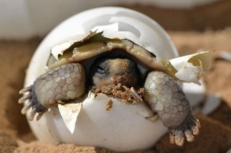
How long is the incubation period for the Mojave desert tortoise?
- 90-120 days
- 10-15 days
- 150-200 days
- 30-60 days
Keep scrolling to find out!
|
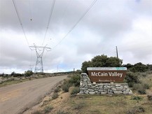
BLM seeks public comment by Oct. 14 on McCain Valley campground improvements
The Bureau of Land Management El Centro Field Office is seeking public input on an Environmental Assessment (EA) for proposed upgrades and modifications at Lark Canyon Campground, Lark Canyon Day Use Area, and Cottonwood Campground located within McCain Valley in Eastern San Diego County, near the town of Boulevard. The 30-day public comment period closes on Wednesday, Oct., 14. (BLM CA News Release)
|
30-day protest period for Cotoni-Coast Dairies proposed plan ends Oct. 26
The Bureau of Land Management Central Coast Field Office has released its Cotoni-Coast Dairies proposed Resource Management Plan Amendment and Environmental Assessment for the California Coastal National Monument that will provide management direction for Cotoni-Coast Dairies public lands in Santa Cruz County. Today’s announcement begins a 30-day protest period and 60-day Governor’s consistency review. (BLM CA News Release)
|
|
Question of the Week Answer
The answer is 1. 90-120 days! Reproduction begins between ages 12-20, with clutch sizes of 1-14 eggs. In years with low rainfall, females may lay few to no eggs. Females can store sperm for five years or longer, meaning they can reproduce for several years after mating. Nests are built and eggs are laid in late spring or early summer. The hatchlings appear in 90 to 120 days. The mother leaves the nest, so once the hatchlings appear, they must survive on their own. (USFWS)
|
|
|
News.Bytes is a publication of the Bureau of Land Management in California.
Bureau of Land Management
California State Office
2800 Cottage Way, Suite W1623
Sacramento, CA 95825
(916) 978-4600
Send comments to the News.Bytes Team | Subscribe to News.Bytes | Unsubscribe
|
     
|
|
|