|
Dear Friends, Partners, and Colleagues,
As we prepare for the days and weeks, after Hurricane Matthew,
I wanted to share with you the current situation and ways we are preparing to
help disaster survivors in the affected areas of the Southeast United States.
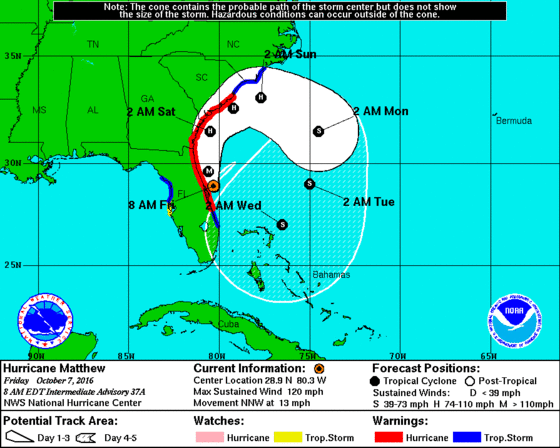
Hurricane Matthew is now a Category 3 hurricane and is
tracking up the Florida coast and into parts of Georgia and South Carolina over
the next 36 hours and longer. More than 500,000 people are without power
in Florida and over 7,000 residents are in shelters in Florida, Georgia and
South Carolina. Those still in the path of the storm need to take
preparations now to evacuate or have sufficient supplies to shelter in place.
This is an on-going weather event and we should not let down
our guard or assume it’s business as usual. Residents throughout the
affected states should be ready to respond to local officials and follow
instructions to survive this storm.
CNCS is working with its federal partners at the Regional
Response Coordination Centers in Atlanta and Philadelphia, as well as the
National Response Coordination Center at FEMA Headquarters in Washington, DC to
help coordinate any requests for assistance from states affected by Hurricane
Matthew. These centers bring together partners from the federal family to
closely coordinate federal resources that may be requested from the affected
state and tribal governments
Evacuations for coastal counties in Florida, Georgia, South
Carolina, and North Carolina are in effect. FEMA encourages residents to listen
to the directions of state, tribal, and local officials in their area. If
instructed to evacuate, don’t wait, evacuate. Please use the resources below to help plan and prepare for this storm!
In Service,
 Kelly DeGraff
Senior Advisor for Disaster Services
Safety and Preparedness Tips
- Residents and visitors from Florida through the mid-Atlantic in
potentially at risk areas, including inland areas, are urged to monitor local
radio or TV stations for updated emergency information, and follow the
instructions of state, local, and tribal officials. If the storm is
expected to affect your area, know your evacuation zone and follow the
direction of local or tribal officials if an evacuation is ordered for your
area.
- Hurricane Matthew has potential for life-threatening rain, wind
and storm surge. This serves as a reminder for residents in areas at-risk to be
affected by this storm to refresh their emergency kits and review family plans.
If you do not have an emergency kit or family plan, or to learn about steps you
can take now to prepare your family for severe weather, visit ready.gov.
- Those in potentially affected areas should be familiar with
evacuation routes, have a communications plan, keep a battery-powered radio
handy and have a plan for their pets. If you have a car, keep a full tank of
gas in it if an evacuation seems likely. Keep a half tank of gas in it at all
times in case of an unexpected need to evacuate. Gas stations may be closed
during emergencies and unable to pump gas during power outages. Plan to take
one car per family to reduce congestion and delay.
-
Individuals should visit www.Ready.gov or www.listo.gov to learn these and other preparedness tips
for tropical storms or hurricanes.
-
Businesses of all sizes should prepare for all hazards including
severe weather to prevent loss of life, property, or disruption to operations.
- Review and update
your business continuity plan and ensure your workforce knows what to do
during severe weather. Resources are available on web sites such as Ready.gov/business and the Sba.gov/disaster-planning.
-
Encourage your
employees to update their family emergency plan to stay connected during severe
weather while at work and develop alternate methods of communication.
-
There is the potential for flooding with this storm. Driving
through a flooded area can be extremely hazardous and almost half of all flash
flood deaths happen in vehicles. When in your car, look out for flooding in low
lying areas, at bridges and at highway dips. As little as six inches of water
may cause you to lose control of your vehicle.
-
If you encounter flood waters, remember – turn around, don’t
drown.
Get to know the terms that are used to identify severe weather
and discuss with your family what to do if a watch or warning is issued:
For a hurricane:
-
A Hurricane Watch is issued when a tropical cyclone containing
winds of at least 74 MPH poses a possible threat, generally within 48
hours.
-
A Hurricane Warning is issued when sustained winds of 74 MPH or
higher associated with a tropical cyclone are expected in 36 hours or less. A
hurricane warning can remain in effect when dangerously high water or a
combination of dangerously high water and exceptionally high waves continue,
even though winds may be less than hurricane force.
For a tropical storm:
-
A Tropical Storm Watch is issued when tropical cyclone containing
winds of at least 39 MPH or higher poses a possible threat, generally within 48
hours.
-
A Tropical Storm Warning is issued when sustained winds of 39 MPH
or higher associated with a tropical cyclone are expected in 36 hours or less.
For flooding:
-
A Flood Watch is issued when conditions are favorable for
flooding.
-
A Flood Warning is issued when flooding is imminent or occurring.
Flood Insurance
If you have flood insurance, there are additional steps you can
take to be prepared before the storm:
Safeguard your possessions
Create a personal
flood file containing information about all your possessions and keep it in a
secure place, such as a safe deposit box or waterproof container.
This file
should have:
-
A copy of your
insurance policies with your agent contact information.
-
A household
inventory: For insurance purposes, be sure to keep a written and visual
(i.e., videotaped or photographed) record of all major household items and
valuables, even those stored in basements, attics or garages. Create files that
include serial numbers and store receipts for major appliances and electronics.
Have jewelry and artwork appraised. These documents are critically important
when filing insurance claims.
-
Copies of all
other critical documents, including finance records or receipts of major
purchases.
Prepare your house
-
First make sure your sump pump is working and then install a
battery-operated backup, in case of a power failure. If you already have a
battery backup, install fresh batteries. Installing a water alarm will also let
you know if water is accumulating in your basement.
-
Clear debris from gutters and downspouts. Clear storm drains in
the street or near your home of leaves and debris.
-
Move electronics, valuables, and important documents to a safe
place.
-
Roll up area rugs, where possible, and store them on higher floors
or elevations. This will reduce the chances of rugs getting wet and growing
mold.
-
Shut off electrical service at the main breaker if the electrical
system and outlets will be under water.
-
If you incur expenses due to protecting your home in preparation
for coming storms and flooding – such as purchasing sandbags – you may be able
to file a claim against your NFIP flood policy for reimbursement. Call your
insurance agent to discuss your coverage and learn more.
-
If your community is flooded, and your property or home has
suffered flood damage, you will be asked to provide a list and photographs of
items that were damaged. If possible, take time before the storm to make a list
of items in your home, including their age and value, and photos of these
items. Should your home experience flood damage, this information will help
your adjustor to calculate the value of the damage and prepare a repair
estimate.
|