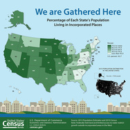
Census Bureau News -- Population Trends in Incorporated Places: 2000 to 2013
FOR IMMEDIATE RELEASE: WEDNESDAY, MARCH 4, 2015
U.S. Cities are Home to 62.7 Percent of the U.S. Population, but Comprise Just 3.5 Percent of Land Area
A majority of the U.S. population lives in incorporated places or
cities, although these areas only make up a small fraction of the U.S. land
area, according to a new report released today by the U.S. Census Bureau. The
percentage of the population living in cities in 2013 was highest in the
Midwest and West at 71.2 percent and 76.4 percent, respectively.
“The higher percentage of people
living in cities in the West can partly be explained by the limited access to
water outside of western cities and federally held land surrounding many of
these cities, which limits growth outside incorporated areas,” said Darryl
Cohen, a Census Bureau analyst and the report’s author. “This is especially
true in Utah, where 88.4 percent of the population lives in an incorporated
place.”
The report, Population
Trends in Incorporated Places: 2000 to 2013, draws from population
estimates data on more than 19,000 cities across the U.S., including trends in
population growth and loss, population density, geographic distribution,
annexation and new incorporations.
The population density in cities <is more
than 46 times higher> than the territory outside of cities. The average
population density for cities is 1,593.5 people per square mile, while the
density outside of this area is only 34.6 people per square mile. Population
density generally increases with city population size. The population density
of cities with 1 million or more people is 7,192.3 people per square mile.
Additional findings:
Density
·Cities with the largest land area are
mostly in the West and have fewer people per square mile. Four places in Alaska
are among the nation’s largest in land area, such as Sitka city and borough,
which consists of 2,870.4 square miles of land and has 3.1 people per square
mile.
·Among large cities, density levels
increased the most for those with strong population growth and stable
boundaries. Population density increased by over 700 people per square mile in
both New York City and Washington, D.C., between 2010 and 2013, the highest
increases in density among cities of 100,000 or more population.
·Population decline or increases in land
area caused decreases in population density in other places.
oDetroit, Mich., and Rockford, Ill., lost
180.7 and 130.9 people per square mile, respectively, between 2010 and 2013.
oModesto, Calif., and Spokane, Wash.,
both increased in population size but decreased in density because of
annexation of land area. Modesto gained almost 3,800 people between 2010 and
2013 but decreased in population density by 837.6 people per square mile
because of the addition of 7.5 square miles of land area.
Annexation
Expansion of municipal boundaries by annexation is uncommon in cities
in the Northeast, but it is common practice in the South and West. Between 2010
and 2013:
·Caliente, Nev. (150 miles north of Las
Vegas) had the largest land area increase. It acquired 55.7 square miles.
·Kirkland, Wash. (a suburb of Seattle)
nearly doubled its population when it increased its boundaries to include
31,796 more people.
·Zionsville, Ind. (a suburb of
Indianapolis) annexed territory that was among the largest in both land area
and population. Zionsville added 9,159 people and 39.5 square miles of land.
New Incorporated Places
·Between 2010 and 2013, there were 17 new
incorporations reported to the Census Bureau. Collectively, these new cities
had a 2013 population of 307,191.
·New cities’ populations ranged from
about 200 in Sandy Point, Texas, to almost 100,000 in Jurupa Valley, Calif.
·Eight new cities were created in the
South (three in Texas alone), four in the West, four in the Midwest and one in
the Northeast.
QuickFacts Beta
Find population
statistics with improved QuickFacts for
all incorporated places. As a result of customer feedback, the tool now
includes the ability to compare six geographies at once; access to multiple
ways to view the data, including charts and maps; and the ability to share,
embed and download content.