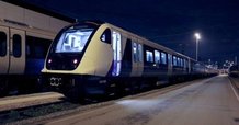
Havering Travel Update for week commencing Monday 27 November

View in a browser

havering london borough
signup for updates

Updates for week commencing Monday 27 November 2017


Ardleigh Green Bridge: Demolition

Bryant Road opening Ardleigh Green Bridge

Bryant Avenue which has been closed due to the Ardleigh Green A127 Bridge works, will open the weekend of 8 December.

TfL are working to complete footway and street lighting works on the new bridge and installing safety barriers. They are also resurfacing the new A127 carriageway and will switch the contraflow next month and reopen Bryant Avenue.

The reopening of Bryant Avenue comes after a series of meetings with senior TfL staff. This will stop the rat runs through side roads within Harold Wood and cause less disruption to parents carrying out the school runs and to people living and working in the area.

Call 020 7222 5600 for all enquiries or email enquire@tfl.gov.uk

Ardleigh Green Bridge 0517


Read More


TFL Rail Updates

TfL Rail logo

TfL Rail 

Please continue to check for TFL updates as Network Rail continue to carry out track and station improvements as part of their Railway Upgrade Plan, as well as Crossrail construction work. 

Click here for an overview of planned track closures for the next six months.

Read more


Avoid roadworks for a quicker journey

traffic lights road sign

Temporary traffic lights and road works on our local roads

Station Lane Hornchurch – Opposite No 54 – Two way Lights on Sunday 26/11/17

Exchange Street Romford (Railway Station) – Two way lights from Saturday 25/11/17 until Sunday 26/11/2017

Roseberry Gardens - near junction of Queens Gardens Upminster - Multi-way signals on Thursday 30/11/17

New Road- Outside Ingrebourne Links Golf Course on junction with Launders Lane - Multi-way signals from Wednesday 29/11/17 until Friday 01/12/17 


Click on the button below for information on work being done by gas, electricity, water, telecom and other utilities as well as those being done by Havering Council.

Read more


Avoid road closures for a quicker journey


ROAD CLOSURES

Road Closures

Gubbins Lane - The East bound side of Gubbins Lane will be closed by UK Power Networks from Tuesday 21/11/17 to Monday 27/11/17

Mercury Gardens southbound - South of the Western Road roundabout – from Wednesday 29/11/2017 until Thursday 30/11/2017 - 19:30 to 05:00

Wingletye Lane - between Lee Gardens Avenue & Woodhall Crescent – from Thursday 30/11/2017 until Friday 01/12/2017 - 19:30 to 05:00

Orchard Village Phase 4 Housing development - A13, Marsh Way, A1306 New Road, Lower Mardyke Avenue, Lowen Road & Holmeoak Avenue - wide load deliveries (up to 4.8metres) – room pods for the new blocks of flats on Lowen Road. Up to 4 deliveries per day Monday 27/11/2017 to Friday 01/12/2017 08:00 to 15:00 

Parking bay suspensions on western side of Lower Mardyke Avenue on the above dates

Any vehicle parked on the western side of Lower Mardyke Avenue preventing access for the wide loads will be relocated 


New Crossrail trains roll out

Commuters using Havering stations have started using brand new train carriages on the new Elizabeth Line between Shenfield and Liverpool Street stations. The new trains offer travellers more space and seating, and air-conditioned carriages. 

Improvements in train services form a key part of our vision for the borough, Havering - making a Greater London with better connections to central London, and Heathrow and west London to follow by 2019. 

Crossrail

TfL logo

Use an app to pay for your travel

Samsung Pay can now be used for pay as you go travel on the Tube, trams, buses and most National Rail services across London 

The app, which can be downloaded from the Samsung Galaxy Apps store, supports MasterCard and Visa credit and debit cards from major UK financial institutions.

Read more 


Pour it away campaign

Transport for London

New TfL map to help people with conditions including claustrophobia and anxiety

People with claustrophobia or other anxiety conditions could find their journeys less stressful as Transport for London (TfL) today launched a new map that shows which stations and sections of the TfL network are underground. 

The new addition to TfL’s broad selection of downloadable Tube maps will help a range of customers navigate the network more comfortably by showing them routes they can take to avoid areas with large stretches of tunnels. 

The tunnels map has been created following suggestions from customers living with claustrophobia or anxiety conditions who find it difficult using the Tube, and has been welcomed by charities. It is one of the many ways that TfL is working to improve the travel experiences of customers using public transport in London.

Download Map


miles the mole

Miles the Mole says “do your share & help clear the air”!

Air pollution in London is linked to almost 10,000 premature deaths a year.

By turning off your engine whenever possible you can help us improve our air quality.

Be prepared for ‘bad air days’ and sign up for pollution alerts by SMS text or voicemail at www.airtext.info/signup