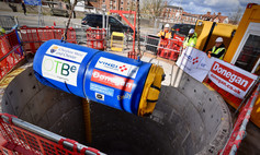
Tunnelling work has started on water drain
Underground tunnelling has now started on the surface water drain through Chester city centre.
The first section has been excavated from shaft three to two, approx. 115m in length and 12m deep along St. Martins Way.
The new drain will run south along St. Martin’s Way, Nicholas Street, Grosvenor Road and Castle Drive. It will be almost 1km in length, 1.2m in diameter and require 9 access shafts spaced along the route, each 7m wide and 12m deep.
The Council is working very closely with the tunnel contractors to ensure disruption is kept to a minimum and the timescales can be kept subject to any unforeseen delays.
Chester Clockwise
Please use your smart phone’s sat-nav (handsfree) to get the best routes, journey time information and live updates on traffic even if you know the route: Chester Clockwise
|
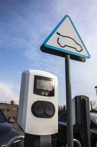
New electric vehicle charging facilities installed
From mid-May, new facilities will open to allow residents and visitors to charge their electric vehicles in more locations, especially in areas where residents have no off-street parking.
Drivers of electric vehicles will also be able to recharge their cars using two dual-socket fast GeniePoint chargers, installed and managed by ENGIE EV Solutions at each of the following car parks:
Bishop Street Car Park - Chester
Brook Street Car Park - Chester
Shrewsbury Road Car Park - Ellesmere Port
Moor Lane Car Park - Frodsham
Chester Road Car Park - Neston
Park Street Car Park - Northwich
|
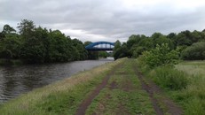
Footpath surface improvements by River Weaver
Footpath surface improvements connecting Hartford blue bridge to Saxons Lane and further on towards Hunt’s Locks park, have begun.
In addition to new and resurfaced pathways, the team working on the project will be clearing overhanging tree branches and carrying out selective removal of scrub and tree vegetation on the main path. This will improve sight lines along the route as well as open-up views to the pond within the Marshall’s Arm Local Nature Reserve and entrance at Saxons Lane.
|

One.Network
To help plan journeys, the One.Network website has live monitoring of road works and traffic congestion across the country. For subscribers, email alerts are also available. The map data is shared with Google and Apple Maps plus major sat-nav operators.
|
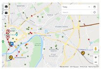
Live roadworks and incidents
For the latest information about roadworks visit the map showing planned and in progress roadworks.
|
Aldford Bridge repairs
A major scheme of works to repair flood-damaged Aldford Bridge will take place from Monday 10 May to Friday 11 June 2021.
The road will be closed between 9.15am to 2.45pm each day, Monday to Friday, to rebuild the bridge parapet. Pedestrian and cyclist access will be maintained during the daily closures.
Mannings Lane South Bridge
A major scheme of works to refurbish and strengthen the bridge on Mannings Lane South, Chester will begin from 17 May 2021.
During the works, the road will need to be closed to vehicles for around 12 weeks. A temporary scaffold footbridge will be installed at the side of the bridge for pedestrians and cyclists, but cyclists should dismount before crossing.
The Greenway below the bridge will also need to be closed for safety reasons to enable scaffolding to be erected and then the installation of strengthening steelwork beneath the bridge.
Castle Drive, Chester
As part of the ongoing drainage tunnel works, Castle Drive will be have a number of closures until November 2021, please follow diversion signs for access to the Little Roodee car park and University Riverside campus.
Castle Drive access is closed from Grosvenor Bridge, there is a diversion in place from Lower Bridge Street for access to the University and Little Roodee car park.
Pedestrian and cycle access to Castle Drive in both directions will be maintained during these works.
|